Storm history of Hurricane Wilma facts for kids
| Category 5 major hurricane (SSHWS/NWS) | |

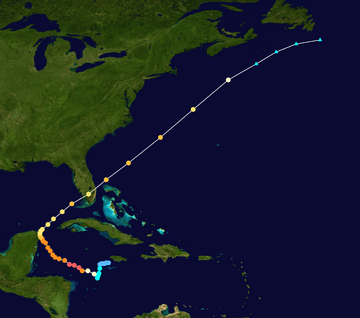
Hurricane Wilma track map
|
|
| Formed | October 15, 2005 |
|---|---|
| Dissipated | October 25, 2005 |
| Highest winds | 1-minute sustained: 185 mph (295 km/h) |
| Lowest pressure | 882 mbar (hPa); 26.05 inHg (Record low in Atlantic) |
| Areas affected | Jamaica, Haiti, Cayman Islands, Cuba, Honduras, Nicaragua, Belize, Yucatán Peninsula, Florida, Bahamas, Atlantic Canada |
| Part of the 2005 Atlantic hurricane season | |
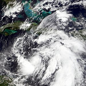
The story of Hurricane Wilma began in October 2005. This storm became one of the strongest tropical cyclones ever recorded in the Western Hemisphere. A large weather system started forming in the Caribbean Sea. It slowly got more organized southeast of Jamaica. By October 15, the system was strong enough for the National Hurricane Center to name it Tropical Depression Twenty-Four.
The depression moved slowly southwest. Conditions were perfect for it to get stronger. On October 17, it became Tropical Storm Wilma. At first, it grew slowly because it was so big. But its thunderstorms slowly got more organized. From October 18 to the next day, Wilma got much stronger very quickly over the Caribbean Sea. In just 30 hours, its central air pressure dropped to a record low of 882 mbar. Its winds also grew to 185 mph (300 km/h). At its strongest, Wilma's eye was tiny, only about 3 miles (5 km) wide. This was the smallest eye ever seen in an Atlantic hurricane. After its inner eye faded, Wilma weakened to a Category 4 hurricane. On October 21, it hit Cozumel and the Mexican mainland. Its winds were about 150 mph (240 km/h).
Wilma weakened as it crossed the Yucatán Peninsula. It then moved into the southern Gulf of Mexico and sped up northeast. Even with strong winds trying to break it apart, the hurricane got stronger again. It hit Cape Romano, Florida as a major hurricane. Wilma weakened as it quickly crossed Florida. It then entered the Atlantic Ocean near Jupiter, Florida. The hurricane got stronger one more time. But then cold air and strong winds broke apart its center. On October 26, it changed into an extratropical cyclone. The next day, what was left of Wilma was absorbed by another storm over Atlantic Canada.
Contents
How Wilma Formed
Hurricane Wilma's start was a bit complex. In the second week of October, a very large weather system formed. It covered most of the Caribbean Sea. This system was helped by air flowing out from a low-pressure area high up in the atmosphere. By October 13, a wide area of low pressure formed. It stayed about 150 miles (240 km) southeast of Jamaica. This might have been helped by other weather systems passing through. Thunderstorms increased and became a bit more organized. But strong winds high up in the atmosphere stopped it from developing quickly at first. The system moved west. By early October 14, the thunderstorms became more focused and organized. This happened as the high-level winds became a bit weaker.
Later on October 14, the system got much more organized. Its showers and thunderstorms became better structured. Conditions high in the atmosphere also became much better. This is when the National Hurricane Center first said that a tropical depression might form there. They started using the Dvorak technique to measure its strength on October 15. The system kept getting more organized. The National Hurricane Center even said it could become a hurricane. By late October 15, the storm's center was clear enough. It had enough organized thunderstorms. So, the National Hurricane Center officially called it Tropical Depression Twenty-Four. It was about 220 miles (345 km) east-southeast of Grand Cayman.
The depression moved slowly west. This was because of weak steering currents. A high-pressure system to its north in the Gulf of Mexico caused this slow movement. At first, the storm's center was wide and not well-defined. Forecasters said the lowest pressure could be anywhere within 60 miles (95 km) of its first reported spot. Experts first thought the tropical depression would drift southwest. Then, it would turn north. They predicted it would be a 105 mph (170 km/h) hurricane near the Isle of Youth within five days. The National Hurricane Center warned that a "dangerous hurricane" could form in the northwestern Caribbean Sea. This was because the depression was in a perfect place to grow. It had low wind shear and very warm ocean waters.
As Tropical Depression Twenty-Four drifted southwest, it steadily got more organized. By early October 16, rainbands started to form. Air was flowing out well from the storm. A large high-pressure area formed above the depression. Even though thunderstorms and rainbands increased, dry air from the north stopped it from getting very organized. The thunderstorms were split into two main areas. Reports from ocean buoys showed that the storm was too big to strengthen past a tropical depression. This was true even though it had tropical storm strength readings from satellite experts. Reconnaissance flights reported winds of about 30 mph (50 km/h).
Wilma Reaches Peak Strength
By early October 17, the outer rainbands faded away. Strong thunderstorms grew near and south of the storm's center. Computer models predicted it would get steadily stronger. It was expected to move west and then turn north. One model predicted it would reach 135 mph (215 km/h) in 36 hours. Other forecasts were more cautious. Thunderstorms kept growing south of the center. The depression became Tropical Storm Wilma at 0600 UTC on October 17. It was about 200 miles (320 km) southeast of Grand Cayman. Right after becoming a tropical storm, the National Hurricane Center predicted Wilma would move west-northwest. They thought it would reach 105 mph (170 km/h) before hitting the northeastern Yucatán Peninsula. The storm continued southwest. Strong thunderstorms stayed near its center. A forecaster said that predicting its path later on was "unusually low" in confidence. This was because different computer models showed very different paths. Late on October 17, a Hurricane Hunters flight into Wilma recorded winds of 50 mph (80 km/h). But the pressure was unusually low at 989 mbar. This pressure is more typical of a weak hurricane. This happened because of many low-pressure areas in the region. This led to less pressure difference and lighter winds. Thunderstorms continued to grow near the center and became much more even.
Tropical Storm Wilma began to turn west-northwest on October 18. During this time, the storm developed a small, sometimes visible eye. It also had an eye feature in the middle of the storm. It kept getting stronger. At 1200 UTC on October 18, Wilma became a Category 1 hurricane. It was about 225 miles (360 km) south-southeast of Grand Cayman. Soon after becoming a hurricane, it started getting much stronger very quickly. A tiny "pinhole" eye, only 9 miles (14 km) wide, formed. This small eye was surrounded by very strong thunderstorms. The cloud tops were extremely cold, about -125°F (-87°C).
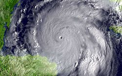
Early on October 19, Wilma became a major hurricane. It continued to get stronger very fast. By 0600 UTC, the storm's winds reached 170 mph (275 km/h). This made Wilma a dangerous Category 5 hurricane. In just 24 hours, Wilma had grown from a 70 mph (110 km/h) tropical storm to a 175 mph (280 km/h) Category 5 hurricane. This had never happened before for an Atlantic hurricane. The eye kept shrinking to about 3 miles (5 km) wide. This is the smallest eye ever known in an Atlantic hurricane. At 1200 UTC on October 19, Wilma reached its strongest winds of 185 mph (300 km/h). The central pressure dropped quickly by 54 mbar in six hours.
At 0800 UTC, a Hurricane Hunters flight recorded a very low central pressure of 884 mbar. This was measured by a special device dropped into the eye. Since the device did not reach the very center, the pressure was estimated to be 882 mbar. This is the lowest pressure ever recorded in an Atlantic hurricane. The pressure kept falling after the Hurricane Hunters left. It's possible the pressure was even lower. At its strongest, hurricane-force winds reached only 50 miles (85 km) from Wilma's small center. Tropical storm-force winds reached about 160 miles (260 km) out.
First Landfall in Mexico
Soon after reaching its strongest point, the coldest cloud tops around the eye warmed a bit. An outer eyewall began to form. This meant the hurricane was going through an eyewall replacement cycle. By late October 19, Hurricane Wilma's winds dropped to 160 mph (260 km/h). The inner 5-mile (8 km) wide eye weakened, and the area of strong winds expanded. Early on October 20, the hurricane weakened to Category 4 status. This happened after the small inner eye disappeared. The 45-mile wide outer eyewall became the new eye. At that time, the pressure was 892 mbar. This was the lowest known pressure for a Category 4 hurricane. Wilma kept its large eyewall as it turned northwest. Experts first thought the hurricane would get stronger again and become a Category 5. One forecast predicted it would hit the Yucatán Peninsula with 165 mph (265 km/h) winds. But Wilma stayed a strong Category 4 hurricane as it moved northwest.
Steering currents remained weak. But a series of troughs (areas of low pressure) broke down the high-pressure system over the Gulf of Mexico. This caused Wilma to turn north-northwest. Conditions remained good for the storm. The eye became clearer early on October 21. At about 2145 UTC on October 21, Wilma hit the island of Cozumel. Its winds were 150 mph (240 km/h). It weakened a little as it continued northwest. It then hit the Mexican mainland near Puerto Morelos at 0330 UTC on October 22. Its winds were 135 mph (215 km/h), with gusts up to 170 mph (270 km/h).
Second Landfall in Florida
On October 22, the high-pressure area north of Wilma disappeared. This left the hurricane moving north across the northeastern Yucatán Peninsula. As the hurricane moved further inland, the eye filled with clouds. The strongest thunderstorms started to warm. The winds slowly weakened as it crossed land. About 26 hours after hitting Cozumel, Wilma moved into the southern Gulf of Mexico near Cabo Catoche. Its winds were about 100 mph (160 km/h). After reaching open waters, Reconnaissance Aircraft reported the remains of an inner eyewall. There was also an outer eyewall between 70 and 90 miles (110 to 145 km) wide. Thunderstorms grew deeper around the eyewalls. The storm's inner core, which had been broken up over land, became a bit more organized.
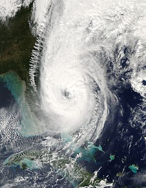
A powerful low-pressure area moving east across the central United States turned the hurricane northeast. It also caused it to speed up. Vertical wind shear increased as strong winds from the southwest increased high up. But despite these strong winds, Wilma kept getting stronger. Early on October 24, Wilma became a major hurricane again. It was about 120 miles (195 km) west-southwest of Key West, Florida. It slowly became better organized. Its large 50-mile (80 km) eye became very clear on satellite and radar. Wilma was able to stay strong because large eyes in hurricanes are more stable. They are also more resistant to vertical wind shear. Even with wind shear of about 30 mph (48 km/h), Wilma strengthened further. It reached winds of 125 mph (200 km/h). It weakened a little as it got closer to Florida. It made landfall at Cape Romano with winds of 120 mph (195 km/h) at about 1030 UTC on October 24.
Hurricane Wilma crossed the Florida peninsula in about 4.5 hours. It kept speeding northeast. It entered the Atlantic Ocean as a weaker 110 mph (175 km/h) hurricane near Jupiter. A strong cold front moved across the area west of Wilma. But the cooler, drier air behind the front could not fully get into the hurricane's center to weaken it. Soon after leaving the Florida coast, Wilma started to get stronger again. This was likely because there was less friction on its eyewall. Also, the warm waters of the Gulf Stream helped. Early on October 25, the hurricane reached a second peak strength of 125 mph. It was about 340 miles (545 km) east of Jacksonville, Florida. At this time, Wilma's large circulation absorbed the smaller Tropical Depression Alpha over the Bahamas. Soon after, the wind shear combined with its fast forward motion of 50 mph (80 km/h). This caused it to slowly weaken. The overall cloud pattern started to get disorganized. The eye became less visible, and the thunderstorms were less even. By 1170 UTC on October 25, the center was northwest of the main thunderstorms. Cold air from the southwest disturbed the storm. The remaining thunderstorms continued to fade. Early on October 26, Wilma turned into an extratropical cyclone. It was about 230 miles (370 km) southeast of Halifax, Nova Scotia. What was left of the storm continued east-northeast. It was absorbed by another extratropical storm on October 27.
Related pages


