The Dakotas facts for kids
Quick facts for kids
The Dakotas
|
|
|---|---|
|
Region
|
|

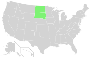
North and South Dakota in light green
|
|
| Country | |
| States | |
| Admission to Union | November 2, 1889 (both North and South Dakota) |
| Area | |
| • Total | 147,816 sq mi (382,840 km2) |
| Population
(2021)
|
|
| • Total | 1,670,324 |
| • Density | 11.30002/sq mi (4.362963/km2) |
| Demonym(s) | Dakotan |
The Dakotas, also called simply Dakota, is a name for the two U.S. states of North Dakota and South Dakota. This name was once used for the Dakota Territory. Today, it describes the shared history, culture, land, animals, and economy of both states.
Contents
What Does "Dakota" Mean?
The name "Dakota" comes from the Dakota people, who are a group of Native American tribes.
A Look Back: History of the Dakotas
The land that makes up the Dakotas was originally home to many Native American tribes, especially different groups of Sioux people, like the Dakota people. The United States government claimed this land through the Louisiana Purchase and the Rupert's Land acquisition. For many years, there were conflicts between the U.S. government and Native American tribes.
Early Territory and Conflicts
Before 1861, this area was part of the Minnesota and Nebraska territories. The Dakota Territory was created in 1861 and included parts of what are now Montana, Nebraska, and Wyoming.
In 1861, a bad harvest and a very cold winter caused great hardship for the Dakota people. They struggled to find food and money. This led to tensions, and in 1862, the Dakota War of 1862 began between the U.S. government and the Dakota people. The U.S. won this war. After the war, many Santee Dakota people were moved by the U.S. government to the Dakota Territory.
Continuing Struggles for Land
Even after the Dakota War, conflicts between Native Americans and Americans continued. Fighting happened along trails like the Bozeman Trail. In 1868, the Treaty of Fort Laramie was signed. This treaty set up the Great Sioux Reservation and said that the Black Hills were "unceded Indian Territory" meant only for native peoples.
However, in 1874, gold was discovered in the Black Hills by George Armstrong Custer's expedition. This discovery caused a gold rush, and the U.S. government broke the treaty. The Indian Appropriations Act of 1876 was passed, which pressured Native Americans to give up their land. This led to the Great Sioux War of 1876. The most famous battle of this war was the Battle of the Little Bighorn, also known as "Custer's Last Stand." Even though the Sioux won this battle, the Agreement of 1877 followed, taking away the Black Hills and moving Native Americans onto reservations.
Becoming States
On February 22, 1889, President Cleveland signed a bill to divide the Dakota Territory into two parts. Congress approved this bill. On November 2, 1889, President Harrison signed the papers to create the U.S. states of North Dakota and South Dakota. He signed them in a way that no one knew which state was officially created first.
Unsettled Land Claims
The debate over the Black Hills land is still ongoing. In 1920, the Sioux began a legal fight to get their ancestral lands back. In 1980, the U.S. Supreme Court ruled that the tribal land was taken illegally from the Sioux and that they should receive money for it. However, the Sioux Nation has refused the money, saying the land was "never for sale."
The Dakotas Today: An Overview
The two states together have about 1,670,324 people. This makes them the 39th most populated region among U.S. states. The Dakotas cover a total area of 147,878 square miles (383,177 square kilometers). This would make them the 4th largest area among U.S. states, just smaller than Montana. The population density is about 9.8 people per square mile (3.8 per km2).
The Dakotas are located in the Midwestern United States. The western part is in the High Plains. Important historical places in the Dakotas include the Black Hills, the town of Deadwood, Fort Buford, Standing Rock Reservation, and Wounded Knee. The Upper Missouri River and its valley are also important natural features.
Most people living in the Dakotas have Northern European backgrounds. About 44.9% are of German ancestry, 21.8% are Norwegian, and 9.6% are of Irish heritage.
Both North and South Dakota have a humid continental climate. This means they have warm to hot summers and very cold winters, sometimes even subarctic temperatures. Because of their different positions on the map, temperatures can vary between the southern and northern parts of the states.
Major Cities in the Dakotas
Here are the largest cities in the Dakotas by population. Pierre, South Dakota is the capital of South Dakota, and Bismarck, North Dakota is the capital of North Dakota.
- Sioux Falls, South Dakota: 202,078 people
- Fargo, North Dakota: 131,444 people
- Rapid City, South Dakota: 78,824 people
- Bismarck, North Dakota: 74,445 people
- Grand Forks, North Dakota: 58,692 people
- Minot, North Dakota: 47,759 people
- West Fargo, North Dakota: 39,985 people
- Aberdeen, South Dakota: 28,210 people
- Williston, North Dakota: 27,029 people
- Dickinson, North Dakota: 25,679 people
- Mandan, North Dakota: 24,206 people
- Brookings, South Dakota: 23,993 people
- Watertown, South Dakota: 23,019 people
- Jamestown, North Dakota: 15,849 people
- Mitchell, South Dakota: 15,659 people
- Yankton, South Dakota: 15,411 people
- Huron, South Dakota: 14,263 people
- Pierre, South Dakota: 14,091 people
- Spearfish, South Dakota: 12,193 people
- Box Elder, South Dakota: 11,746 people
- Vermillion, South Dakota: 11,695 people
- Brandon, South Dakota: 11,048 people
See also
 In Spanish: Las Dakotas para niños
 | Valerie Thomas |
 | Frederick McKinley Jones |
 | George Edward Alcorn Jr. |
 | Thomas Mensah |

