Trinity River (Texas) facts for kids
Quick facts for kids Trinity River |
|
|---|---|

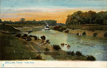
Trinity River, Dallas, Texas (postcard, c. 1901–1907)
|
|
 |
|
| Other name(s) | Río de La Santísima Trinidad Río de La Trinidad |
| Country | United States |
| Physical characteristics | |
| Main source | North Texas, near the Red River |
| River mouth | Trinity Bay, at Chambers County, Texas 0 ft (0 m) 29°44′35″N 94°42′12″W / 29.74306°N 94.70333°W |
| Length | 710 miles (1,140 km) |
| Basin features | |
| Basin size | 15,589 sq mi (40,380 km2) |

The Trinity River is a long river in Texas, United States. It stretches about 710-mile (1,140 km) from its start in northern Texas. The river begins just a few miles south of the Red River. High cliffs separate the Trinity's starting point from the Red River.
Long ago, the Caddo people called this river Arkikosa or Daycoa. However, in 2022, Caddo language experts found that their old language did not have an "R" sound. So, Arkikosa was likely a mistake for Akokisa. The Atakapa tribe, who lived near the coast, used Akokisa to mean "river people." In 1687, a French explorer named Robert Cavelier de La Salle called it "River of Canoes." Later, in 1690, Spanish explorer Alonso de León gave it the name "La Santísima Trinidad," which means "the Most Holy Trinity." This is where the name Trinity River comes from today.
Contents
Where Does the Trinity River Flow?

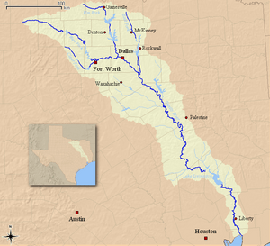
The Trinity River is made up of four main parts, like big branches. These are the West Fork, the Clear Fork, the Elm Fork, and the East Fork. Each branch starts in a different area and flows towards a central point.
River Branches
The West Fork Trinity River starts in Archer County. It flows southeast through two large man-made lakes: Lake Bridgeport and Eagle Mountain Lake. Then, it goes eastward through Lake Worth and the city of Fort Worth.
The Clear Fork Trinity River begins north of Weatherford, Texas. It flows southeast through Lake Weatherford and Benbrook Lake. This fork then turns northeast and joins the West Fork near downtown Fort Worth. After they meet, the river continues as the West Fork.
The Elm Fork Trinity River flows south from near Gainesville. It passes through Ray Roberts Lake and east of Denton. Finally, it flows through Lewisville Lake.
The West Fork and the Elm Fork come together as they reach the city of Dallas.
The East Fork Trinity River (also known as the Bois d'Arc River on old maps) starts near McKinney, Texas. It flows through Lavon Lake and then Lake Ray Hubbard. This fork joins the main Trinity River just southeast of Dallas.
From Dallas, the Trinity River flows southeast. It passes through rich farmlands and the pine forests of eastern Texas. About 65 miles (105 km) before it reaches the coast, a large earthen dam was built in 1968. This dam created Lake Livingston, a very important reservoir.
The river eventually empties into Trinity Bay. This bay is an arm of Galveston Bay, which connects to the Gulf of Mexico. The river's end is near the town of Anahuac, southeast of Houston.
Smaller Streams Joining the Trinity
Many smaller streams and creeks flow into the Trinity River, adding to its waters. Some of these include:
- Clear Fork of the Trinity River
- East Fork of the Trinity River (Bois d'Arc River)
- Elm Fork of the Trinity River
- West Fork of the Trinity River
- Bachman Branch
- Cedar Creek
- Clear Creek (confluence with Elm Fork in Denton)
- Mountain Creek
- Menard Creek
- Fossil Creek (Texas)
- Johnson Creek
- Red Oak Creek
- Richland Creek
- White Rock Creek
- Rowlett Creek
- Big Creek
- Fourmile Creek
- Five Mile Creek
- Ten Mile Creek
- Sycamore Creek
- Marine Creek
Big Projects Along the River
For a long time, people dreamed of making the Trinity River deep enough for large ships. In the early 1900s, some locks were even built downstream from Dallas. Locks are like water elevators that help boats move between different water levels. However, this big shipping channel project was stopped after World War I. Today, there are no plans to finish these old locks.
However, other important projects are happening! The U.S. Army Corps of Engineers is working on the Dallas Floodway Extension Project. This project helps reduce flood risks, restore natural areas, and create new places for people to enjoy in Dallas.
The Trinity River Corridor Project in downtown Dallas aims to turn the river's flood zone into a huge urban park. This park will be one of the largest in the country. It includes three special bridges designed by a famous architect named Santiago Calatrava.
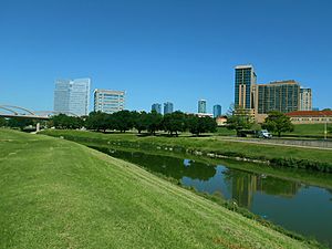
In Fort Worth, a similar project called the Trinity River Vision is underway. This plan helps the city grow in a smart way, preventing too much urban sprawl (when cities spread out too much). It creates a lively downtown area along the river, allowing Fort Worth's central business district to expand over many years.
Dealing with Floods
The Trinity River can sometimes flood, causing problems for nearby communities. Big floods happened in 1844, 1866, 1871, and 1890. A very serious flood in May 1908 led to major changes. The river became very wide and deep. Many people lost their homes, and there was a lot of damage. Power, telephone, and train services were all stopped. People in West Dallas faced many difficulties, and many animals were lost in the floodwaters.
After the 1908 flood, people wanted to control the river better. They also needed a strong bridge to connect Oak Cliff and Dallas. A newspaper publisher, George B. Dealey, suggested building a strong concrete bridge. In 1912, the Oak Cliff Viaduct (now called the Houston Street Viaduct) opened. It cost about US$19.7 million (a lot of money back then!). This bridge was the longest concrete structure in the world at that time.
To protect against future floods, large protective walls called levees were built starting in 1932. These levees were made taller in 1960 and are still about 30 feet (9 m) high today. Current plans, like the Dallas Floodway Extension project, aim to make these levees even better.
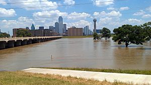
While major floods are less common now, smaller floods still happen sometimes. For example, the Trinity River had minor flooding in the spring of 2015 and the summer of 2022.
See also
 In Spanish: Río Trinity para niños
- Atakapa
- List of longest rivers of the United States (by main stem)
- List of the ten longest Texas rivers
- List of Texas rivers
- Trinidad, Texas
- Trinity River Authority
- Trinity River National Wildlife Refuge
- Trinity River Vision Project
- Trinity, Texas


