
Ubehebe Craters facts for kids
Quick facts for kids Ubehebe Craters |
|
|---|---|

View onto Ubehebe Crater and Little Hebe Crater
|
|
| Highest point | |
| Elevation | 2,467 ft (752 m) |
| Naming | |
| Etymology | Etymology |
| Geography | |

 Ubehebe Craters
Location in California
|
|
| Parent range | Death Valley, Basin and Range Province |
| Geology | |
| Age of rock | Holocene |
| Mountain type | Volcanic field |
| Last eruption | 150 BCE? |
| Climbing | |
| Access | Death Valley National Park |
The Ubehebe Craters are a fascinating group of volcanic craters located in the northern part of Death Valley in California. This area is home to about 14 to 16 craters spread across a 3-square-kilometre (1.2 sq mi) space. The most famous and largest is Ubehebe Crater, which is about 800 metres (2,600 ft) wide and 235 metres (771 ft) deep.
Many of the other craters are partly hidden or worn down, making them harder to spot. Besides the craters, you can also find remnants of other volcanic features here, like a small scoria cone (a hill made of volcanic rock fragments) and a tuff cone (a cone-shaped hill made of volcanic ash).
These craters are connected to cracks in the Earth's crust, called faults, that run through the area. This region has experienced volcanic activity for a very long time, over 10 million years! Today, the Ubehebe Craters are part of the Death Valley National Park, and visitors can explore them.
Scientists believe all the Ubehebe Craters formed during one big explosive event about 2,100 years ago. This makes it one of the most recent volcanic events in southern California. The chance of new eruptions happening here is very low.
Contents
Discovering the Ubehebe Craters
The name "Ubehebe" is pronounced as YOU-bee-HEE-bee. Its exact meaning is not fully clear. Some believe it might relate to a "basket" or a natural shape in the local Owens Valley Paiute language.
Local Shoshone tribes have their own name for the area: "Tempintta Wosah". This means "basket in the rock" or "coyote's basket," referring to the crater's shape. Scientists first officially noted these volcanoes during studies in 1932.
Exploring the Craters and Their Surroundings
The Ubehebe Craters are found in the northern Death Valley. They sit on the slopes of Tin Mountain, which is part of the Panamint Range and Cottonwood Mountains. This location is about 100 kilometres (62 mi) from Furnace Creek. The area is known for its rolling hills, called the Ubehebe Hills.
The main volcanic area is about 752 metres (2,467 ft) above sea level. It features two main types of craters called maars: Ubehebe Crater and the smaller Little Hebe Crater. A maar is a wide, flat-bottomed volcanic crater formed by an explosion. There are also 14 to 16 other craters in this 3 square kilometres (1.2 sq mi) area. Most of these smaller craters are between 100–200 metres (330–660 ft) wide.
Many of the smaller craters are quite old and have been worn down by weather. Some are even partly buried by sand and rocks, making them hard to see.
Ubehebe Crater: The Big One
Ubehebe Crater is the largest and gives the whole area its name. It is a maar, measuring 800 metres (2,600 ft) across and 235 metres (771 ft) deep. Around its edge is a tuff ring, which is a low, wide ring of volcanic ash and rock fragments. This huge crater dug deep into the older rocks beneath the surface.
The inside walls of Ubehebe Crater look different on each side because a fault (a crack in the Earth's crust) runs through it. You can see areas where rock has slid down, channels carved by water, and large piles of debris. Sometimes, a temporary lake forms at the bottom of the crater after heavy rains. The rim of the crater is covered with black volcanic ash. This ash layer can be up to 50 metres (160 ft) thick near the crater, getting thinner further away.
Little Hebe Crater and Other Features
South of Ubehebe Crater is Little Hebe Crater. This is a tuff cone, which is a cone-shaped hill made of volcanic ash. Its crater is about 100 metres (330 ft) wide and 20 metres (66 ft) deep. Around Little Hebe, you can see layers of pyroclastic surge deposits. These are striking white and black bands of volcanic material.
Little Hebe Crater likely formed within a long, bowl-shaped area called the "Amphitheater." Between this area and Ubehebe Crater, there are also remains of a scoria cone. Other smaller craters are grouped to the west of Ubehebe Crater.
Volcanic Deposits Around the Craters
Explosive eruptions from the Ubehebe Craters spread volcanic material up to 4 kilometres (2.5 mi) away. This material covers an area of about 15 square kilometres (5.8 sq mi). These deposits are mostly base surges. Base surges are fast-moving clouds of hot gas and volcanic ash that form when magma (molten rock) mixes explosively with water.
These deposits often show wave-like patterns, like ripples, where streams or road cuts have exposed them. You can find rocks up to 15 centimetres (5.9 in) in size mixed in with the ash, lapilli (small volcanic rocks), and lava bombs (larger blobs of lava).
-
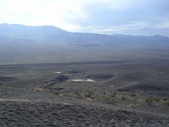
Ubehebe Craters
-
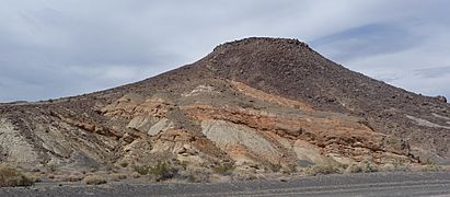
Volcanic outcrops in the Ubehebe Craters
-
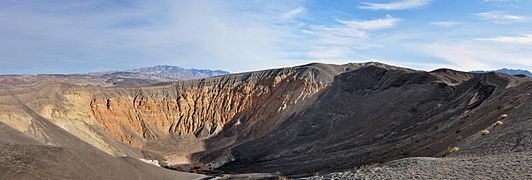
Ubehebe Crater
-
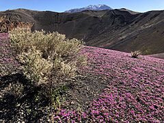
Ubehebe Crater during an April bloom


The Geology of the Ubehebe Craters
Death Valley is part of a larger geological area called the Basin and Range Province. This region is known for its many parallel mountain ranges and valleys. For the past 10 million years, the Death Valley area has experienced volcanic activity. This activity created the Ubehebe Craters, along with other features like Yucca Mountain and a 400,000-year-old cinder cone in southern Death Valley.
The Ubehebe Craters formed within layers of sedimentary rocks. These rocks, like conglomerates (rocks made of pebbles and gravel) and sandstones, can be seen inside the craters. Beneath these are even older rocks, including Paleozoic carbonates (rocks made of minerals like limestone).
Cracks in the Earth: Faults
The Ubehebe Craters sit on top of a fault system. A fault is a large crack in the Earth's crust where rocks have moved past each other. This fault forms the edge of the Tin Mountain range. Near the craters, this fault has created steep slopes called scarps.
This fault, known as the Tin Mountain fault, even cuts through Ubehebe Crater itself. It also connects with another nearby fault, the Northern Death Valley fault.
What the Rocks Are Made Of
The Ubehebe Craters erupted a type of volcanic rock called alkali basalt. This rock contains various minerals, including olivine and plagioclase. Scientists study the chemistry of these rocks to understand where the magma (molten rock) came from deep inside the Earth. They believe it came from very old rock material beneath the Mojave Desert.
During the eruptions, pieces of the surrounding older rocks, like gneiss and quartz, were also blasted out. These rock fragments are now scattered around the craters.
Climate and Water's Role
The Ubehebe Craters experience extreme weather. Summers are very hot, and winter temperatures often drop below freezing. In the past, during colder periods like the Little Ice Age, snow patches could form in the craters.
Today, Death Valley receives very little rain, about 56 millimetres per year (2.2 in/year). However, this rainfall can be sudden and heavy, causing erosion and sometimes creating temporary lakes in the craters.
The explosive eruptions that formed the Ubehebe Craters involved a lot of water. This might suggest that the climate was wetter back then. However, scientists later found that the craters formed during a relatively dry period. The explosions happened because even small amounts of groundwater (water stored underground) mixed with the hot magma.
How the Craters Formed: An Explosive History
The Ubehebe Craters are considered quite young in geological terms, forming during the Holocene epoch. They all formed in one major event about 2,100 years ago, around 150 BCE. Scientists used special dating methods, like studying ancient magnetic fields and radioactive elements, to figure this out.
This makes the Ubehebe Craters one of the most recent basaltic (lava-based) eruptions in the continental United States. The entire eruption episode likely lasted only a few days or weeks, perhaps a few months at most.
The Eruption Sequence
The eruptions probably started with the formation of a small scoria cone. Then, the activity became much more explosive. This happened when hot magma met groundwater underground, causing powerful steam explosions. These explosions created the clusters of craters we see today. The "Amphitheater" and the western craters formed first, with Ubehebe Crater forming last.
The explosion that created Ubehebe Crater was incredibly powerful. It blasted fragmented lava and rocks high into the air. These materials then fell back down, covering an area of about 39 square kilometres (15 sq mi). Fast-moving clouds of gas and ash, called base surges, also erupted from the craters, spreading across the landscape.
The eruptions would have been an amazing sight. Ash from the eruption likely affected nearby Shoshone communities. However, there are no stories about this event passed down through their oral tradition.
After the Eruptions
After the eruptions ended, erosion by wind and water began to shape the landscape. Water carved gullies (small valleys) into the volcanic deposits. Temporary crater lakes sometimes formed in some craters, leaving behind clay deposits. Even today, the main Ubehebe Crater can sometimes hold water.
Scientists do not believe there is any active magma chamber beneath the volcano now. This means the risk of new eruptions is very low.
Visiting the Ubehebe Craters
A paved road leads to the Ubehebe Craters, and there is a parking lot right on the rim of Ubehebe Crater. A trail goes around the rim, offering amazing views. You can also take another path that goes down to the bottom of the main crater.
Many Tourists have visited the Ubehebe Craters for a long time. They are a popular spot in the northern part of Death Valley National Park. The desert scenery around the craters is truly beautiful and unique.
Staying Safe at the Craters
While visiting, it's important to be aware of a few things. The paths can be tiring, especially if you walk down into Ubehebe Crater and then have to climb back up. The ground inside the crater can be loose and unstable, so watch your step. Always be prepared for the extreme heat, especially in summer.
Watching for Volcano Activity
Because the Ubehebe Craters formed relatively recently, the California Volcano Observatory keeps an eye on them. They have installed equipment, like a seismometer (which detects ground movement), to monitor the area.
The Ubehebe Craters are classified as a "Moderate Threat" volcano by the USGS (United States Geological Survey). This means there's a low but possible risk of future activity. In case of new eruptions, fast-moving steam blasts and ash clouds could occur in a zone that reaches Scotty's Castle. However, since these craters likely formed in one main event, the chance of new eruptions is considered very low.
See also
- Geology of the Death Valley area
- Racetrack Playa
