
Warwick, Rhode Island facts for kids
Quick facts for kids
City of Warwick
|
||
|---|---|---|
|
City
|
||
|
Warwick City Hall, Brush Neck Cove, the Caleb Greene House, and T. F. Green Airport
|
||
|
||

Location in Kent County, Rhode Island
|
||
| Country | United States | |
| State | Rhode Island | |
| County | Kent | |
| Founded | 1642 | |
| Incorporated (town) | August 8, 1647 | |
| Incorporated (city) | April 21, 1931 | |
| Named for | Robert Rich, 2nd Earl of Warwick | |
| Government | ||
| • Type | Mayor-council | |
| Area | ||
| • Total | 49.75 sq mi (128.85 km2) | |
| • Land | 35.00 sq mi (90.65 km2) | |
| • Water | 14.75 sq mi (38.20 km2) | |
| Elevation | 20 ft (6 m) | |
| Population
(2020)
|
||
| • Total | 82,823 | |
| • Density | 2,366.30/sq mi (913.64/km2) | |
| Time zone | UTC−5 (Eastern) | |
| • Summer (DST) | UTC−4 (Eastern) | |
| ZIP Codes |
02886, 02888–02889
|
|
| Area code(s) | 401 | |
| FIPS code | 44-74300 | |
| GNIS feature ID | 1220018 | |
| Website | www.warwickri.gov | |

_--_2006_--_6.jpg)

.jpg)

Warwick (pronounced WORR-ik) is a city in Rhode Island, United States. It is the third-largest city in the state. In 2020, about 82,823 people lived there. Warwick is located about 12 miles (19 km) south of Providence, Rhode Island. It is also about 63 miles (101 km) southwest of Boston, Massachusetts.
Warwick was started by Samuel Gorton in 1642. It has been part of many important moments in American history. The city was greatly damaged during King Philip's War (1675–1676). It was also the place of the Gaspee Affair. This event was the first armed resistance against the British. It happened even before the famous Boston Tea Party. This made it a key step towards the American Revolution.
Warwick was home to important military leaders. Nathanael Greene, a general in the Revolutionary War, lived here. He was George Washington's second-in-command. George S. Greene, a Civil War general and hero of the Battle of Gettysburg, also called Warwick home.
Today, Warwick is home to T. F. Green Airport. This is Rhode Island's main airport. It serves the Providence area and helps with flights for Logan International Airport in Boston. Warwick was also once home to Rocky Point Amusement Park. This popular park closed in 1995 and is now a state park.
Contents
Warwick's Early History
Warwick was first settled by Samuel Gorton in 1642. He bought the land, called the Shawhomett Purchase, from the Narragansett leader Miantonomi. The payment was 144 fathoms of wampum, which are beads made from shells. This land included areas that are now Coventry and West Warwick, Rhode Island.
However, two other Narragansett leaders, Sacononoco and Pumham, said Miantonomi sold the land without their permission. They asked the Massachusetts Bay Colony for help. In 1643, Massachusetts sent soldiers to Shawomett to arrest Gorton and his group. Most of Gorton's followers gave up. Gorton then sailed to England to ask the King for a special document called a charter. He got a lot of help from Robert Rich, 2nd Earl of Warwick. Because of his help, Gorton and the settlers changed the name of their colony from Shawumet to Warwick.
The constant problems from the Massachusetts Bay Colony led the other three colonies in Narragansett Bay (Providence Plantations, Portsmouth, and Newport) to join with Warwick. Together, they got a British royal charter. This allowed them to form the Colony of Rhode Island and Providence Plantations.
In 1772, Warwick was the site of the first violent act against the British government. This was known as the Gaspee Affair. Local patriots boarded the Gaspee, a British ship that was enforcing taxes in Narragansett Bay. During the fight for the ship, the commanding officer, Lt. Dudingston, was shot and badly hurt. This was the first time blood was shed in the American Revolution. The patriots then took all the cannons and weapons from the Gaspee and burned the ship.
During the American Revolution, soldiers from Warwick fought in many battles. These included the battles of Montreal, Quebec, Saratoga, Monmouth, and Trenton. They were also present when the British surrendered at Yorktown in 1781.
Getting Around Warwick
Warwick has several important highways that help people travel.
 Interstate 95 is a major road that goes through Rhode Island.
 Interstate 295 connects to I-95. It provides a direct route to Woonsocket and into Massachusetts.
 Route 37 (also known as Lincoln Avenue Freeway) connects I-295 to U.S. Route 1.
- There is also the T. F. Green Airport Connector Road, which leads directly to the airport.
The Rhode Island T. F. Green International Airport is located in Warwick. It is the main airport for Rhode Island. The name was changed from T.F. Green Airport in 2021. The airport also has a train station, T. F. Green Airport. This station is part of the Commuter Rail Line. It offers train service to Providence Station and Boston's South Station on weekdays.
Warwick's Geography
Warwick is located at coordinates 41.7181 degrees North and -71.4152 degrees West.
The city covers about 49.6 square miles (128.5 square kilometers). About 35.5 square miles (91.9 square kilometers) of this is land. The remaining 14.1 square miles (36.5 square kilometers) is water. Warwick has a long waterfront area on its eastern side. This starts with the Providence River at its northern border.
Conimicut Point marks where the river ends and Narragansett Bay begins. Narragansett Bay stretches past Warwick's southern border towards the Atlantic Ocean. Two peninsulas in southern Warwick, Warwick Neck and Potowomut, create Greenwich Bay.
Warwick shares borders with several other towns. To the north is Cranston. To the west is West Warwick. To the south is East Greenwich. The southernmost part of Warwick, Potowomut, is a bit separated. You have to go through East Greenwich to reach it by land. Because of this, Warwick also borders North Kingstown. This means Warwick touches two Rhode Island counties: Providence County and Washington County.
Here are some of the smaller communities, or villages, located within Warwick:
- Apponaug
- Arnold's Neck
- Brush Neck Cove
- Buttonwoods
- Cedar Tree Point
- Chepiwanoxet
- Coles
- Conimicut
- Cowesett
- Duby Grove
- East Natick
- Gaspee Point
- Greenwood
- Governor Francis Farms
- Hillsgrove
- Hoxsie
- Lakewood
- Lincoln Park
- Nausauket
- Natick
- Norwood
- Oakland Beach
- Old Buttonwoods
- Pawtuxet Village (also in Cranston)
- Pocasset
- Pontiac (also in Cranston)
- Potowomut
- Riverview
- Shawomet
- Warwick Neck
- Wildes Corner
People of Warwick
| Historical population | |||
|---|---|---|---|
| Census | Pop. | %± | |
| 1830 | 5,529 | — | |
| 1840 | 6,726 | 21.6% | |
| 1850 | 7,740 | 15.1% | |
| 1860 | 8,916 | 15.2% | |
| 1870 | 10,453 | 17.2% | |
| 1880 | 12,164 | 16.4% | |
| 1890 | 17,761 | 46.0% | |
| 1900 | 21,316 | 20.0% | |
| 1910 | 26,629 | 24.9% | |
| 1920 | 13,481 | −49.4% | |
| 1930 | 23,196 | 72.1% | |
| 1940 | 28,757 | 24.0% | |
| 1950 | 43,028 | 49.6% | |
| 1960 | 68,504 | 59.2% | |
| 1970 | 83,694 | 22.2% | |
| 1980 | 87,123 | 4.1% | |
| 1990 | 85,427 | −1.9% | |
| 2000 | 85,808 | 0.4% | |
| 2010 | 82,672 | −3.7% | |
| 2020 | 82,823 | 0.2% | |
| U.S. Decennial Census | |||
Warwick is part of the larger Providence metropolitan area. This area had a population of over 1.6 million people in 2010.
According to the 2020 United States census, Warwick had 82,823 people. There were 36,555 households and 21,150 families. The city's population density was about 2,366 people per square mile (914 per square kilometer).
About 16.9% of the people in Warwick were under 18 years old. About 21.9% were 65 years or older. The average age in Warwick was 46.0 years.
How Warwick is Governed
Warwick is led by a mayor and a city council. The current mayor is Frank Picozzi. The city council has nine members.
Warwick is divided into three areas for the Rhode Island Senate. These areas are currently represented by Democrats: Michael McCaffrey (District 29), Jeanine Calkin (District 30), and Kendra Anderson (District 31). The city is also part of Rhode Island's 2nd congressional district. This district is currently represented by Democrat Seth Magaziner.
In presidential elections, Warwick has usually voted for the Democratic Party. A Republican candidate has not won in Warwick for over thirty years.
| Year | GOP | DEM | Others |
|---|---|---|---|
| 2020 | 42.20% 19,578 | 55.70% 25,845 | 2.19% 1,018 |
| 2016 | 44.25% 18,338 | 48.35% 20,038 | 7.39% 3,064 |
| 2012 | 37.21% 15,027 | 60.54% 24,448 | 2.24% 905 |
| 2008 | 38.37% 16,541 | 59.85% 25,802 | 1.79% 770 |
| 2004 | 41.02% 16,640 | 57.10% 23,164 | 1.87% 760 |
| 2000 | 32.37% 12,741 | 60.85% 23,948 | 6.78% 2,669 |
| 1996 | 26.83% 10,414 | 59.64% 23,152 | 13.53% 5,254 |
| 1992 | 29.88% 13,348 | 45.90% 20,504 | 24.22% 10,822 |
| 1988 | 45.29% 18,052 | 54.34% 21,662 | 0.37% 149 |
Warwick's Economy
Warwick is part of the Pawtuxet River Valley area. Before it closed, the company Eckerd Corporation had its main office in Warwick.
Some of the largest employers in Warwick include Kent Memorial Hospital, Citizens Bank, and UPS. Other big employers are MetLife, the City of Warwick itself, and Leviton Manufacturing. Large stores like Wal-Mart and J.C. Penney also employ many people. The Community College of Rhode Island, Kenney Manufacturing, and Inskip Automall are also major employers.
Famous People from Warwick
Many notable people have connections to Warwick:
- Bill Almon, a former Major League Baseball (MLB) player. He went to Warwick Veterans Memorial High School.
- Rocco Baldelli, a former MLB player and current manager for the Minnesota Twins. He attended Bishop Hendricken High School.
- John Belluso, a playwright.
- Brenda Bennett, a musician and former member of the group Vanity 6. She was born in Warwick.
- John Brown, an American merchant who was involved in the Gaspee Affair. Brown University is named after him.
- Vanessa Carlton, a musician.
- Marnee Carpenter, an actress.
- Liam Coen, an American football coach.
- Kate Fagan, a sports journalist.
- Thomas Holden, an American general and Rhode Island Supreme Court justice.
- John Hynes, the head coach for the NHL Nashville Predators. He was born in Warwick.
- Michaela McManus, an actress known for roles on One Tree Hill and Law & Order: Special Victims Unit. She went to Toll Gate High School.
- Martha McSally, a former Senator from Arizona. She was born and grew up in Warwick.
- Walt Mossberg, a personal technology journalist and editor. He was born and grew up in Warwick and went to Pilgrim High School.
- Nolan North, a voice actor. He attended Bishop Hendricken High School.
- Nicholas O'Neill (1985–2003), a writer, actor, and musician. He was the youngest victim of The Station nightclub fire.
- David Petrarca, a director of TV, film, and theater, including Game of Thrones.
- Dave Shalansky, an actor. He attended Toll Gate High School.
- Joe Shekarchi, the Speaker of the Rhode Island House of Representatives.
- Kyle Smith, Vice President of Player Personnel for the Atlanta Falcons.
- Chris Terreri, a former NHL goalie. He attended Pilgrim High School.
- Dan Wheeler, a former MLB pitcher. He attended Pilgrim High School.
- Fred Whittingham, a former NFL player and coach. He attended Warwick Veterans Memorial High School.
- James Woods, an actor. He attended Pilgrim High School.
Education in Warwick

Public schools in Warwick are managed by Warwick Public Schools. The city has two main public high schools: Toll Gate High School and Pilgrim High School. These high schools are planned for renovations in March 2025. This follows a $350 million bond approved by the city council to rebuild them.
Warwick also has two public middle schools: Winman Junior High School and Warwick Veterans Junior High School. Aldrich Junior High School and Gorton Junior High School closed in 2016 as part of a school consolidation plan. Lynn Dambruch is the superintendent who leads the school department.
In addition to public schools, Warwick has private schools. Bishop Hendricken High School is a Catholic high school for boys. It prepares students for college. Rocky Hill School is a private school for students from Pre-Kindergarten through 12th grade. It is a co-ed school located on the Potowomut peninsula in Warwick. Even though it's in Warwick, the school lists an East Greenwich address.
The Knight Campus of the Community College of Rhode Island is also located in Warwick. It is on what used to be the Knight Estate.
Images for kids
-
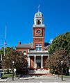
Warwick City Hall
-
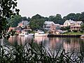
Brush Neck Cove
-
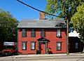
The Caleb Greene House
-
T. F. Green Airport
-
Seal of Warwick, Rhode Island
-
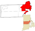
Location of Warwick in Kent County, Rhode Island
See also
 In Spanish: Warwick (Rhode Island) para niños
