
Auvergne facts for kids
Quick facts for kids Auvergne |
|||
| Region | |||
|
|||
| Country | |||
|---|---|---|---|
| Préfecture | Clermont-Ferrand | ||
| - coordinates | 45°47′N 3°05′E / 45.783°N 3.083°E | ||
| Area | 26,013 km² (10,044 sq mi) | ||
| Population | 1,354,104 (2013) | ||
| Density | 52 /km² (135 /sq mi) | ||
| Subdivisions | 4 departments | ||
| Timezone | CET (UTC+1) | ||
| - summer (DST) | CEST (UTC+2) | ||
| ISO 3166-2 | FR-C | ||


Auvergne (Occitan: Auvèrnha / Auvèrnhe) was a region in France. It's now part of a bigger region called Auvergne-Rhône-Alpes. You can find it in the Massif Central, which is a high area in south-central France. People from Auvergne are called Auvergnats.
The region was made up of four main areas called departments: Allier, Cantal, Haute-Loire, and Puy-de-Dôme. Its main city was Clermont-Ferrand.
Contents
A Look Back in Time
Auvergne got its name from the Arverni. They were a very strong Gallic tribe (an ancient group of people) who lived there a long time ago.
The Auvergne region we know today was created from older areas. These included the old province of Auvergne and parts of Bourbonnais, Languedoc, and Lyonnais.
During World War II, a city in Auvergne called Vichy (in the Allier department) became important. It was the main place for the French government at that time.
Exploring Auvergne's Geography
Auvergne covers about 26,013 square kilometers (10,044 sq mi). This is about 4.8% of France's total land area. It was surrounded by six other regions. These included Burgundy to the northeast and Rhône-Alpes to the east and southeast. To the south was Languedoc-Roussillon, and Midi-Pyrénées was to the southwest. Limousin was to the west, and Centre-Val de Loire was to the northwest.
 |
Centre-Val de Loire | Burgundy | |
|
| Limousin | Rhône-Alpes | |||
| Midi-Pyrénées | Languedoc-Roussillon | Rhône-Alpes |
The land in Auvergne is very diverse. You can find valleys, mountains, green meadows, and thick forests. A large part of the region is in the Massif Central. This is a high area in south-central France with many mountains and flat-topped plateaus.
Volcanoes and Lakes
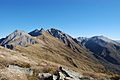
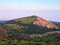
Auvergne is famous for its many dormant volcanoes. These are volcanoes that are not active right now. You can see them mainly in the Monts Dore and the Chaîne des Puys areas. The highest point in Auvergne is the Puy de Sancy (45°31′42″N 2°48′50″E / 45.52833°N 2.81389°E). It stands tall at 1,885 meters (6,184 ft) high.

The northern part of Auvergne, in the Allier department, has small hills. A flat area, the valley of the Allier river, cuts through these hills.
Auvergne also has about 50 freshwater ponds and lakes. Some of these lakes are high up in the mountains. Many of them were formed by volcanoes. The Guéry Lake is the highest lake in Auvergne. It is 1,244 meters (4,081 ft) high in the Puy-de-Dôme department.
Main Rivers
The most important rivers in the region are:
- The Loire: This river flows through the Haute-Loire department in the southeast. After leaving and returning from the Rhône-Alpes region, it forms the northeastern border of the Allier department.
- The Allier: This river flows right through the center of the Auvergne region.
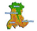
Auvergne's Departments
The Auvergne region was made up of four main areas called departments. Think of them like states or provinces within the region. Each department has its own main city, called a Préfecture.
| Département | Préfecture | ISO 3166-2 |
Population (2012) |
Area (km²) |
Density (Inh./km²) |
|---|---|---|---|---|---|
| Allier | Moulins | FR-03 | 342,911 | 7,340 | 46.7 |
| Cantal | Aurillac | FR-15 | 147,415 | 5,726 | 25.7 |
| Haute-Loire | Le Puy-en-Velay | FR-43 | 225,686 | 4,977 | 45.3 |
| Puy-de-Dôme | Clermont-Ferrand | FR-63 | 638,092 | 7,970 | 80.1 |
People and Cities
In 2012, the Auvergne region had about 1,354,104 people living there. This means there were about 52.1 people per square kilometer.

Here are the ten largest cities in Auvergne:
| City | Population (2012) |
Départment |
|---|---|---|
| Clermont-Ferrand | 141,569 | Puy-de-Dôme |
| Montluçon | 38,072 | Allier |
| Aurillac | 27,074 | Cantal |
| Vichy | 25,315 | Allier |
| Cournon-d'Auvergne | 19,223 | Puy-de-Dôme |
| Moulins | 18,959 | Allier |
| Le Puy-en-Velay | 18,599 | Haute-Loire |
| Riom | 18,484 | Puy-de-Dôme |
| Chamalières | 17,480 | Puy-de-Dôme |
| Issoire | 14,296 | Puy-de-Dôme |
What Auvergne is Known For
Auvergne is mostly an agricultural region. This means farming is a very important part of its economy. Many Cattle (cows) are raised here. They are used for both meat (beef) and for their milk. This milk is then used to make several famous cheeses. Some of these delicious cheeses include Bleu d'Auvergne, Cantal, Fourme d'Ambert, and Saint-Nectaire.
-
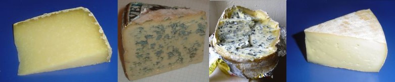
Four cheeses from Auvergne: Cantal, Bleu d'Auvergne, Fourme d'Ambert, Saint-Nectaire.

The main industry in Auvergne is making tyres (tires for vehicles). Two big companies, Michelin and Dunlop, have a strong presence here. Michelin's main office and history are in Clermont-Ferrand, while Dunlop is in Montluçon.
Gallery
-

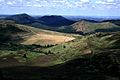
Valley to the east of Noyant-d'Allier.
-
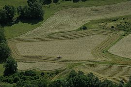
Making hay, Vallée de la Maronne, Cantal.
-
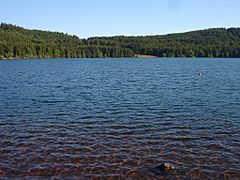
Bouchet lake, Haute-Loire.
-
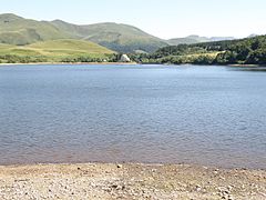
Guéry Lake, Puy-de-Dôme.
-
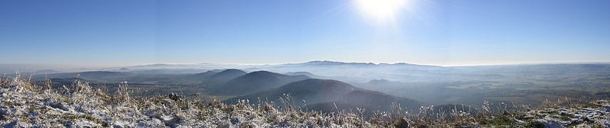
Panoramic view from the Puy de Dôme.


Images for kids
-
Auvergne terrain map
-
Volcanoes.
-
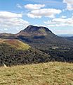
Puy de Dôme.
-
Puy du Sancy.
-
Puy Pariou.


See also
 In Spanish: Auvernia para niños
