
Beltana facts for kids
Quick facts for kids BeltanaSouth Australia |
|||||||||||||||
|---|---|---|---|---|---|---|---|---|---|---|---|---|---|---|---|

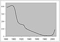
Beltana population since 1880
|
|||||||||||||||

Beltana
Location in South Australia
|
|||||||||||||||
| Established | 2 October 1873 (town) 29 May 1997 (locality) |
||||||||||||||
| Postcode(s) | 5730 | ||||||||||||||
| Elevation | 296 m (971 ft) | ||||||||||||||
| Time zone | ACST (UTC+9:30) | ||||||||||||||
| • Summer (DST) | ACST (UTC+10:30) | ||||||||||||||
| Location |
|
||||||||||||||
| LGA(s) | Outback Communities Authority | ||||||||||||||
| State electorate(s) | Stuart | ||||||||||||||
| Federal Division(s) | Grey | ||||||||||||||
|
|||||||||||||||
|
|||||||||||||||
| Footnotes | Adjoining localities | ||||||||||||||
Beltana is a small town about 540 kilometres (336 mi) north of Adelaide, South Australia. It's famous for still being there, even though the main reasons for its existence are long gone! Beltana's story started in the 1870s. Back then, people found copper nearby, and important projects like the Australian Overland Telegraph Line and The Ghan railway were built. But things started to change in 1941 when coal mining began in Leigh Creek. The town's future was really affected in 1983 when the main road was moved away from it. Today, the town, its old cemetery, and railway buildings are part of a special State Heritage Area, protected since 1987.
Beltana has important connections to the Overland Telegraph, the transcontinental railway, mining, and services for the outback. It also has links to the Australian Inland Mission and places connected to "Afghan" camel drivers. These drivers used to transport goods using camels.
The town used to have horse racing events, including annual picnic races and a gymkhana, since 1876. They also had a big pastoral field day every two years. Sadly, these events are no longer held. The Beltana roadhouse, which was the town's local store, closed in 2016. It is now about 12 kilometres (7.5 mi) away from Beltana on the main highway.
Contents
Exploring Beltana's Landscape
Beltana sits about 240 meters above sea level. It's located between the Warrioota and Sliding Rock creeks, which are often dry. Nearby is Mount Deception. Because the land is quite flat and close to the creeks, heavy rain can sometimes cause flooding.
The weather here can be very unpredictable. Beltana has gone six months without any rain (in 1960–61). It has also had six months with over 300 mm of rain (in 1975–76). Long periods of drought have meant that no animals could be kept on the land (like from 1903–09). The amount of rain has varied a lot, from only 57 mm in 1902 to a record 408.6 mm in 1974. The average rainfall over a long time is 205 mm. Sometimes there are frosts in winter and hailstorms. Snow was even recorded once on Mount Hack and Mount Stuart in July 1971.
Native plants like saltbush, bluebush, and other acacias are growing back in the town area. This is because fewer animals have been grazing there in recent decades. River red gum trees grow along the creeks. You can also find a population of yellow-footed rock-wallabys nearby.
Beltana's Past: A Journey Through Time
Who Lived Here First?
The first people to live in this area were the Kuyani and Adnyamathanha Aboriginal people. They used the nearby springs as a camping spot. When Europeans arrived, their traditional way of life changed. Many Aboriginal people started working on farms that raised animals. In the early days of European settlement, they had a camp near Beltana Station. Later, they moved closer to the town at Warrioota Creek. As more people moved away from Beltana, some Aboriginal people began living in the empty buildings. By the late 1960s, they made up most of the town's population again.
How Beltana Got Its Name
Beltana gets its name from a nearby sheep station. This station, located west of the current town, was a stopping point for travelers, missionaries, explorers, and miners. The name Beltana might come from the Adnyamathanha word for running water or crossing of the waters. It could also be a changed version of veldana, meaning skin or cloak.
Some language experts think the name comes from the Kuyani name for the place, Paltha-nha. However, old records and explanations are different. It's probably connected to the nearby Warioota Creek, maybe where it joins another creek. Other ideas suggest it came from a village called Beltana in Tasmania, or an Irish word about bravery. One station manager even thought it simply meant the place where the station bell was rung.
The Town's Beginning and Growth
Land in this area was first used for farming by John Haines in 1854. Thomas Elder took it over in 1862. In 1867, it became part of the Beltana Pastoral Company, owned by Elder and Samuel Stuckey. In 1866, Elder and Stuckey brought in 109 "Afghans" and their camels. This group helped create the main transport system for the area in the mid-1800s.
The first building in town was Martin's Eating House, built in 1870. It was set up to serve people after copper was found at Sliding Rock, about 20 kilometres (12 mi) east of Beltana. The town's location was already chosen for a repeater station for the Australian Overland Telegraph Line. In 1870, Charles Todd's telegraph contract brought more activity to the area. A telegraph station was built next to the only house there.
In 1873, the town was surveyed and planned out with 115 plots of land. Space was left for parks and future growth. Plots were also set aside for a school, police station, and hospital. On October 2, 1873, Beltana was officially declared a town.
In 1877, a lot of water was found at the Sliding Rock mine, causing it to fail. Many people then moved to Beltana. The old mine buildings are still there today and are listed on the South Australian Heritage Register. The mine's failure and the arrival of the railway in 1881 brought many families to Beltana. Within five years, the town had a brewery, a store, and a school. Other copper mines in the area started working. Beltana became the main point for sending out copper ore, sheep, and wool by train. In 1869, a new ship named the Beltana was built. It sailed between Port Augusta and London until 1897.
Beltana's best years were between 1875 and the 1920s. During this time, mining was very active. The town had a brewery, two hotels, a post and telegraph office, a school, a police station, a doctor, a court-house, a church, a baker, a butcher, a blacksmith, a hospital, a railway station, a cricket team, and race meetings. It also had a saddle maker, a carriage maker, a mining exchange, and several shops. At times, as many as 500 people lived there.
Over time, new machines, mine closures, drought, and the Great Depression caused Beltana to slowly decline. It stopped being a busy center for the region after 1920. The railway line was changed in 1956, and the main road was moved in 1983. These changes sealed the town's fate.
Famous Explorers Who Visited
For a while, Beltana was the starting point for many trips into central Australia. Explorers like Ernest Giles in 1872, Peter Warburton in 1873, Ross in 1874, Lewis in 1874–75, and Lawrence Wells in 1883 all began their journeys here.
Beltana Today
Today, all the original reasons for Beltana to exist are gone. The railway, the main road, mining, and the telegraph are no longer there. Even the nearby Leigh Creek coal mine closed. In 1984, the population was only 9 people. Now, the town survives as a historic tourist spot and a living ghost town.
The town does not have piped water. The water pipe built in the 1940s from Leigh Creek to Sliding Rock went around Beltana. Water comes from different wells and the old railway dam. Puttapa Springs, a constant water source, is about 8 kilometres (5 mi) from the town.
Most of the old buildings that are still standing are now privately owned. This means they are not open to the public. There is a special walking trail with signs that tell the history of many buildings in the town. Beltana also has a campground run by the community, which you can book online.
Beltana Locality Boundaries
In 1997, official boundaries were set for a larger area called Beltana. This was done to include the areas around the original Government Town of Beltana.
Important Buildings in Beltana
.jpg)
Smith of Dunesk Mission
The Smith of Dunesk Mission was started in 1894 by the Presbyterian Church of South Australia. It was funded by a gift from a Scottish woman named Henrietta Smith. She wanted the money to help Aboriginal people in South Australia.
The first Presbyterian manse (a minister's house) was bought in 1898. Reverend John Flynn, who later started the Australian Inland Mission and the Flying Doctor Service, lived there in 1911. In 1919, it became the Beltana Australian Inland Mission nursing home. This nursing home helped people until new hospital facilities became available in Leigh Creek in the mid-1950s.
The Beltana Mission Hall dates back to 1878 or 1879. It was likely built for community events. It was used for dances and the local court meetings. Mrs. Anna Doig also ran a Sunday School there for many years. The building was later bought by the church in 1902. It was renovated in 1918 and again in 1955. Today, the building is kept in good condition. It was used for a special event in 2012 to celebrate the founding of the Australian Inland Mission.
Police Station
Because of concerns about the behavior of workers on the railway line, a mounted policeman was assigned to the area in 1879. In 1881, a permanent police building was completed. A police sergeant and two mounted constables lived there. Cyril Allen, Beltana's last official policeman, closed the office in 1958. Now, policing for the area is handled from Leigh Creek.
School Life in Beltana
When the Sliding Rock mine closed, its school was taken apart and moved to Beltana in 1878. A new stone school building was finished in October 1893. The original metal school building was then used as the teacher's house. In 1925, the old school was taken apart again. Its materials were used to add a shelter shed and a woodwork room to the new building. The school closed in 1967. Now, students are driven daily to the Leigh Creek area school, which is 40 kilometers away. Beltana's school always had only one teacher. Its highest number of students was 52 in 1904.
The Overland Telegraph Station
A temporary station for the Overland Telegraph Line opened in Beltana in 1872. The telegraph line itself was set up there in 1871, and the first message was sent in July 1871. A permanent station was built in 1875. This building is still standing today and is a private home. Up to six staff members worked there. They relayed morse code messages along the telegraph lines that connected Darwin to Adelaide.
The station received its first phone message in 1878. In 1940, the telegraph services were moved to a telephone switchboard at the local shop. The station finally closed by 1956 because an automatic exchange had been installed.
The Railway Station
On January 19, 1878, Sir William Jervois officially started work on the new northern railway, known as The Ghan, in Port Augusta. The line reached Hawker in June 1880. It arrived in Beltana on July 2, 1881. Later, it reached Marree in 1884, Oodnadatta in 1891, and Alice Springs in 1929. In 1956, the narrow gauge line through Beltana was replaced by a standard gauge line that went around the town. The railway line is now closed.
Important Note for Visitors
Even though the town might look empty, and you might think you can walk into any building, many of them are privately owned. Some are even lived in! So, please respect privacy. Many inhabited houses have "Keep Out" signs.
Images for kids
-
Beltana population since 1880
