
Brisbane River facts for kids
Quick facts for kids Brisbane River |
|
|---|---|

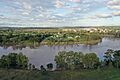
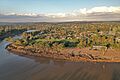
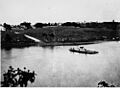
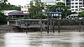
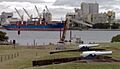
Brisbane River from Kangaroo Point
|
|

Location of river mouth in Queensland
|
|
| Other name(s) | Maiwar |
| Country | Australia |
| State | Queensland |
| Region | South-East Queensland |
| City | Brisbane |
| Physical characteristics | |
| Main source | Mount Stanley east of Nanango 213 m (699 ft) 26°39′S 152°22′E / 26.650°S 152.367°E |
| River mouth | Moreton Bay east of Brisbane 0 m (0 ft) 27°24′S 153°9′E / 27.400°S 153.150°E |
| Length | 344 km (214 mi) |
| Basin features | |
| River system | Brisbane River |
| Basin size | 13,652.3 km2 (5,271.2 sq mi) |
| Tributaries |
|
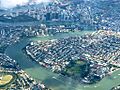
The Brisbane River is the longest river in South East Queensland, Australia. Its traditional name in the Turrbal language is Maiwar. This important river flows right through the heart of Brisbane city. It then empties into Moreton Bay, which is part of the Coral Sea.
In 1823, John Oxley was the first European to explore the river. He named it after Sir Thomas Brisbane, who was the Governor of New South Wales at that time. The settlement that grew up around the river also took the name Brisbane. The river is like a long, winding "Brown Snake" to locals, because of its muddy waters and curvy path.
The Brisbane River stretches for 344 kilometers from Mount Stanley. A large dam, the Wivenhoe Dam, creates Lake Wivenhoe. This lake is Brisbane's main source of drinking water. The river is home to special creatures like the rare Queensland lungfish and bull sharks. Sadly, the Brisbane River cod is now extinct.
For many years, the river was a vital transport route. It connected Brisbane with Ipswich before a railway was built in 1875. Over time, the river's water quality became very poor. However, efforts have been made to improve its health.
The Brisbane River has experienced several major floods throughout history. Notable floods occurred in 1893, 1974, January 2011, and February 2022. These events show the river's powerful nature.
Today, the river is crossed by 16 major bridges. The Clem Jones Tunnel provides an underground road crossing. You can also travel along the river using CityCat and KittyCat ferry services. The Port of Brisbane is a busy shipping hub located at the river's mouth.
Contents
- Understanding the River's Name
- The River's Journey
- River Branches and Creeks
- A Look Back: History of the Brisbane River
- River Floods: Understanding the Impact
- Navigating the Brisbane River
- River Crossings: Bridges and Ferries
- Environmental Health of the River
- River Flora: Plants of the Brisbane River
- River Fauna: Animals of the Brisbane River
- Water Transport
- Events on the Brisbane River
- Named in its Honour
- Images for kids
- See also
Understanding the River's Name
The river has two important names. In 1823, John Oxley named it after Sir Thomas Brisbane. Sir Thomas was the Governor of New South Wales at that time. Oxley was exploring the area to find a good spot for a new settlement.
The traditional name for the river is Maiwar. This name comes from the Turrbal language. The Turrbal people are an Aboriginal group who have lived in the Brisbane area for a very long time. Today, the name Maiwar is also used for a local government area.
Some historical records suggest that Aboriginal people might have used different names for various parts of the river. This shows their deep connection to each bend and section of the waterway.
The River's Journey

The Brisbane River begins its journey in the mountains east of Kingaroy. Its two main branches meet south of Mount Stanley. The highest point where the river's water collects is in the Bunya Mountains, about 992 meters above sea level.
From its source, the river flows south past towns like Linville and Toogoolawah. It then joins with the Stanley River near Somerset Dam.
The river then flows into Lake Wivenhoe. This large lake is very important for Brisbane's water supply. After the dam, the river winds eastward. It meets the Bremer River near Ipswich. Then, it travels through many of Brisbane's suburbs, including Jindalee and Indooroopilly.
Finally, the Brisbane River passes busy wharves like Pinkenba Wharf. It flows through the Port of Brisbane and into Moreton Bay.
Kangaroo Point Cliffs: A Natural Landmark
On the southern side of the river, you can see the impressive Kangaroo Point Cliffs. These cliffs are made from a special volcanic rock called Brisbane tuff. This rock formed about 220 million years ago during the Triassic period.
Long ago, these cliffs were a quarry. People who were part of the early settlement used to cut out blocks of this strong rock. They used it to build many of Brisbane's first buildings. This hard work helped create the city we know today.
River Branches and Creeks
Many smaller rivers and creeks flow into the Brisbane River. These are called tributaries.
- From the north, major tributaries include Breakfast Creek, Moggill Creek, and the Stanley River.
- From the south, important waterways like Bulimba Creek, Norman Creek, Oxley Creek, Bremer River, and Lockyer Creek join the river.
- Other smaller creeks also add their waters, such as Cooyar Creek, Goodna Creek, and Pullen Pullen Creek.
A Look Back: History of the Brisbane River


Before Europeans arrived, the Brisbane River was very important to the Turrbal Aboriginal people. It was a spiritual place and a key source of food, especially fish. They also used traditional farming methods along its banks.
Early European explorers like James Cook and Matthew Flinders visited Moreton Bay. However, they did not discover the river's mouth. This was common for many rivers on Australia's east coast.
The First European Discovery
In 1823, four men who had been shipwrecked accidentally discovered the river. They were Thomas Pamphlett, John Finnegan, Richard Parsons, and John Thompson. They had been sailing south from Sydney but were blown off course by a storm. They walked along the river's banks for nearly a month.
Later that year, John Oxley, a surveyor, sailed into Moreton Bay. He was looking for a good place for a new settlement. To his surprise, he met one of the shipwrecked men, John Finnegan. Finnegan helped Oxley explore the river further upstream. Oxley was amazed by the many fish and tall pine trees he saw.
Early Settlement and Changes
In 1824, a settlement was established. Explorers like Allan Cunningham and Patrick Logan explored the river even more. In 1825, the settlement moved to North Quay.
The river's entrance was marked with buoys in 1825 to help ships navigate. The first small private wharves were built around 1848. By 1850, settlers had claimed most of the good farming land along the river.
From 1862, the river was dredged to make it easier for ships to pass. For many years, sand and gravel were removed from the riverbed. This changed the river's natural flow.
In 1896, a sad event occurred when the ferry Pearl capsized. About 40 lives were lost in this accident.
The River in the 20th Century

By 1928, the river's water quality had become very poor due to the growing city. It was no longer safe for public baths. However, in the 1930s, some parts of the river were still clear enough to see the bottom.
Over time, the river's banks were cleared of trees. New animals and plants were introduced, which harmed the river's natural environment.
In 1977, Queen Elizabeth II turned on the Jubilee Fountain. This fountain shot river water 75 meters into the air. In 1987, the "Year of the River" was celebrated to highlight the river's importance.
Throughout the 20th century, dredging made the river deeper and wider. This increased the tidal flow further upstream.
The River in the 21st Century
In 2020, there was a small mix-up when Google Maps briefly showed the Brisbane River as Ithaca Creek. This was quickly corrected.
River Floods: Understanding the Impact


The Brisbane River has flooded many times throughout history. However, the Wivenhoe Dam helps to control the water levels and reduce the size of floods.
Before modern dredging, floods often left behind sandbanks. These made it difficult for ships to travel. Today, large ships mostly stay in the lower parts of the river. Dredging in the upper parts has stopped, helping the river recover.
Since 1841, there have been 12 major floods recorded in Brisbane.
- The highest flood ever recorded was on 14 January 1841, reaching 8.43 meters.
- In February 1893, a series of floods caused the highest recorded levels in the city center. Several lives were lost during these floods.
- On 27 January 1974, Brisbane experienced its largest flood of the 20th century, reaching 5.45 meters.
- After the Wivenhoe Dam was built, major floods still occurred. These include 11 January 2011 (4.45 meters) and 28 February 2022 (4.0 meters).
Flooding can be very damaging because the river's winding path slows down the water's flow to Moreton Bay. When the river overflows its banks, water can spread quickly over large areas of the city.

For many years, the river was dredged and widened. This allowed larger ships to carry goods to and from Brisbane. Today, the river is no longer dredged for commercial purposes.
Before railways, the river was a key route between Brisbane and Ipswich. By 1825, buoys were placed to guide ships. Pilots were also hired to help ships enter Moreton Bay and travel upstream. In the 1930s, flying boats even used the river's waters for take-offs.
Obstacles like the Seventeen Mile Rocks were removed in 1965. This made the river safer for navigation. Land has also been reclaimed at the river's mouth. This created more space for the Port of Brisbane facilities.
Historically, the river's natural tidal limit was only 16 kilometers upstream. Thanks to continuous dredging, the tide now reaches 85 kilometers upstream.
River Crossings: Bridges and Ferries

The first bridge across the Brisbane River was the original timber Victoria Bridge. It opened in 1865. The current concrete Victoria Bridge is the fourth one built on that spot. The earlier bridges were damaged by marine life and floods.
As of 2012, there are 16 major bridges crossing the Brisbane River. These include the famous 1940 Story Bridge and the Sir Leo Hielscher Bridges. There are also two other major bridges further upstream.
The Clem Jones Tunnel opened in 2010. It was the first underground road crossing beneath the river. The Cross River Rail tunnel is also under construction and is expected to be finished in 2029.
The Moggill Ferry still carries vehicles across the river northeast of Ipswich.
Railway and Pedestrian Bridges
The Albert Bridge was the first railway bridge, opening in 1876. It was rebuilt after the 1893 flood. The Merivale Bridge, opened in 1978, connects different railway lines.
Four bridges are designed for walkers and cyclists. These include the Goodwill Bridge and Kurilpa Bridge in the city. The Eleanor Schonell Bridge also carries public buses to the University of Queensland. The Jack Pesch Bridge connects Indooroopilly and Chelmer.
Brisbane Riverwalk: Paths Along the River


The Brisbane City Council has built many walking paths along the riverbanks. These are called the Brisbane Riverwalk. The longest part runs between Newstead and Toowong. Another popular section is beneath the Kangaroo Point Cliffs.
Some parts of the Riverwalk are built out over the water. A special floating walkway once connected the Story Bridge to New Farm.
During the 2011 floods, a large section of the floating Riverwalk broke away. It floated downstream, causing concerns for bridges. Tugboats safely guided the large pieces under the Sir Leo Hielscher Bridges. The damaged Riverwalk was rebuilt as a stronger, fixed structure. Construction finished in September 2014.
Environmental Health of the River

In the past, the river's surface was sometimes covered by a harmful weed called water hyacinth. This plant came from South America.
Environmentally, the river has faced challenges for many years. In 2000, the river's mouth did not meet national environmental standards. The lower parts of the river received a very poor rating in 2008 for water quality.
The main causes of pollution are too many nutrients, chemicals, pesticides, and bacteria. These wash into the river from the surrounding land. The river is also quite murky, and swimming in its waters is not recommended.

From the 1950s, the river was dredged to remove sand and gravel. This caused the water to become cloudy and led to erosion of the banks. Environmentalists worried that the sediment was harming seagrass beds, which are important for animals like dugongs. Because of public concern, commercial dredging stopped in 1998.
Dredging still happens to keep the river deep enough for boats. In 2018, the river's water quality still did not meet many government standards. High levels of nitrogen and phosphorus were found. These often come from farms along the riverbanks.
Research in 2019 suggested that the river's murky brown color comes from mud moving between the channel and mudbanks. Scientists believe that planting certain plants could make the river clearer and bluer.
River Flora: Plants of the Brisbane River
The river has important areas where mangroves still grow. These include areas near drainage pipes, in Breakfast Creek, and around the shipping terminals. These mangroves are now protected as nature reserves.
The harmful water hyacinth weed still grows in some parts of the river. However, it is not a major threat to drinking water supplies.
River Fauna: Animals of the Brisbane River

Queensland Lungfish: A Living Fossil
In the late 1800s, the Queensland lungfish was only found in the Mary and Burnett rivers. To help this unique species survive, it was introduced to other waterways. Today, healthy populations of lungfish live in the Brisbane River.
Brisbane River Cod: A Lost Species
The freshwater parts of the Brisbane River once had a special type of cod called the Brisbane River cod. This fish was similar to the Murray cod. Sadly, this unique native fish disappeared between the 1930s and 1950s. This was due to changes in its habitat and too much fishing. Today, the river has been restocked with cod from the Mary River.
Bull Sharks: River Predators
The Brisbane River is home to many bull sharks. These sharks can live in both salty and fresh water. They can grow very large, up to 3.5 meters long. They can also be very protective of their territory.
Because of the presence of bull sharks, swimming in the Brisbane River is not advised. There have been recorded shark attacks in the river, including on family pets. Local councils warn people not to swim in the river, even far upstream.
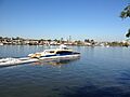
Water Transport
The river is a busy waterway for transport. CityCats and other ferries carry passengers through the city center.
Events on the Brisbane River
The Brisbane River hosts many exciting events throughout the year. These include the Brisbane Festival and the Riverfire fireworks display. Many schools and clubs also use the river for rowing and sailing competitions.
Riverfire: A Spectacular Display
Riverfire is a huge fireworks display that lights up the Brisbane River. It began in 1998 and is now the opening event of the Brisbane Festival.
Before the fireworks, the RAAF performs an aerial display. Aircraft like the F/A-18 Super Hornet fly over the city. In the past, the F-111 aircraft was famous for its "dump-and-burn" display. This spectacular show could be seen from far away.
Riverfire attracts hundreds of thousands of people to the riverbanks each year. In 2009, it was recognized as one of Queensland's "Q150 Icons" for its role as a major event.
Named in its Honour
The electoral district of Maiwar was created in 2017. It was named after the river's traditional Aboriginal name.
Images for kids
-
Moggill Ferry Reserve was completely under water after the 2022 Flood
-
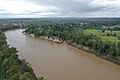
Muddy Brisbane river covered with debris after days of raining
-
Goodna Boat Ramp in May 2023
-
Cockatoo Island of Brisbane River
-
Newcomb Park, Riverhills QLD
-
Riverview Farm Park on 11 March 2022
-
-
-
-

-
-
-
-
-
-
-

-
-
-
-
-
-

-
-
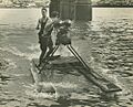
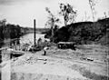
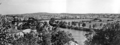
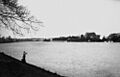
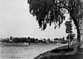
A historic photo of the Brisbane River


See also
 In Spanish: Río Brisbane para niños
