Dayton metropolitan area facts for kids
Quick facts for kids
Metro Dayton
|
|
|---|---|
| Dayton–Springfield–Kettering, OH Combined Statistical Area |
|

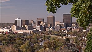
City of Dayton Skyline from
Woodland Cemetery and Arboretum |
|
| Country | |
| State | |
| Largest city | Dayton |
| Other cities (Suburbs) | - Kettering - Beavercreek - Huber Heights - Fairborn - Centerville - Miamisburg - West Carrollton |
| Area | |
| • Total | 1,715 sq mi (4,440 km2) |
| Population
(2020)
|
|
| • Total | 814,049 |
| • Rank | 73rd in the U.S. |
| • Density | 478/sq mi (185/km2) |
| Time zone | UTC−05:00 (Eastern Standard Time) |
| • Summer (DST) | UTC−04:00 (Eastern Daylight Time) |
Metro Dayton, also known as the Miami Valley, is a large urban area in Ohio, USA. It's officially called the Dayton–Kettering–Beavercreek, OH Metropolitan Statistical Area. This area includes three counties in the Miami Valley region and has the city of Dayton as its main hub. In 2020, Metro Dayton was the fourth-largest metropolitan area in Ohio. It was also the 73rd largest in the entire United States, with a population of 814,049 people.
Contents
Counties in Metro Dayton
Metro Dayton is made up of three main counties:
Cities and Towns
Metro Dayton has many cities and towns, ranging from large cities to smaller communities.
Largest Cities
These cities have more than 100,000 people:
- Dayton (the main city) – 135,944 people
Mid-sized Cities
These cities have between 25,000 and 100,000 people:
- Kettering – 57,862 people
- Beavercreek – 46,636 people
- Huber Heights – 43,439 people
- Fairborn – 34,977 people
- Troy – 26,432 people
- Xenia – 25,463 people
- Riverside – 24,350 people
Smaller Cities and Towns
Many other places with fewer than 25,000 people are also part of Metro Dayton. Some of these include:
- Centerville
- Trotwood
- Piqua
- Miamisburg
- Springboro
- Vandalia
- Englewood
- Clayton
- West Carrollton
- Tipp City
- Oakwood
- Bellbrook
- Union
- Moraine
- Brookville
- Germantown
- Carlisle
- West Milton
- Cedarville
- New Lebanon
- Yellow Springs
- Covington
- Wilberforce
- Jamestown
Dayton's Larger Area
The Dayton–Springfield–Kettering Combined Statistical Area (CSA) is an even larger region. It includes Metro Dayton plus other nearby areas. These areas are called Metropolitan Statistical Areas (MSAs) and Micropolitan Statistical Areas (μSAs).
Parts of the CSA
- Metropolitan Statistical Areas (MSAs)
- Dayton (Greene, Miami, and Montgomery counties)
- Springfield (Clark County)
- Micropolitan Statistical Areas (μSAs)
- Greenville (Darke County)
- Urbana (Champaign County)
- Sidney (Shelby County)
As of 2020, this larger CSA had a population of 1,086,512 people. Some people have even called the idea of Dayton and Cincinnati growing together "Daytonnati." This is because the outer parts of these two large areas are getting closer.
Population Changes
| Historical population | |||
|---|---|---|---|
| Census | Pop. | %± | |
| 1900 | 161,759 | — | |
| 1910 | 193,496 | 19.6% | |
| 1920 | 289,181 | 49.5% | |
| 1930 | 358,041 | 23.8% | |
| 1940 | 383,975 | 7.2% | |
| 1950 | 545,723 | 42.1% | |
| 1960 | 727,121 | 33.2% | |
| 1970 | 850,266 | 16.9% | |
| 1980 | 830,070 | −2.4% | |
| 1990 | 843,835 | 1.7% | |
| 2000 | 848,153 | 0.5% | |
| 2010 | 799,232 | −5.8% | |
| 2020 | 814,049 | 1.9% | |
| Population 1990-2010 with 2011 estimate. | |||
The population of Metro Dayton has changed over the years. In 2010, there were about 799,232 people living here. The area is mostly White (80.40%) and African American (14.90%). About 1.90% of the population is Hispanic or Latino.
The average household income in 2010 was about $47,381. This means half of the households earned more than this, and half earned less.
From 2000 to 2010, many people moved from the main city of Dayton to its surrounding suburbs. For example, the population grew by 19% in Beavercreek and 40% in Springboro. Even though some suburbs saw small declines, many of them, like Kettering and Huber Heights, remained strong.
The way metropolitan areas are defined by the Census Bureau has changed. Because of new rules, Clark County and Preble County are no longer part of the Dayton Metropolitan Statistical Area. This is why the population numbers for the Dayton MSA look different in the 2010 census compared to earlier years.
| County | 2020 Census | 2010 Census | Change | Area | Density |
|---|---|---|---|---|---|
| Montgomery County | 537,309 | 535,153 | +0.40% | 464 sq mi (1,200 km2) | 1,158/sq mi (447/km2) |
| Greene County | 167,966 | 161,573 | +3.96% | 416 sq mi (1,080 km2) | 404/sq mi (156/km2) |
| Miami County | 108,774 | 102,506 | +6.11% | 410 sq mi (1,100 km2) | 265/sq mi (102/km2) |
Colleges and Universities

The Dayton area is home to many colleges and universities where students can continue their education:
- Air Force Institute of Technology (Wright-Patterson Air Force Base)
- Antioch College (Yellow Springs)
- Cedarville University (Cedarville)
- Central State University (Wilberforce)
- Kettering College of Medical Arts (Kettering)
- Sinclair Community College (Dayton)
- University of Dayton (Dayton)
- Wilberforce University (Wilberforce)
- Wittenberg University (Springfield)
- Wright State University (Fairborn)
- Clark State Community College (Springfield)
Largest Employers
Many large companies and organizations provide jobs in the Dayton region:
- Wright-Patterson Air Force Base (around 30,000 employees)
- Premier Health Partners (around 14,335 employees)
- Kettering Health Network (around 9,500 employees)
- Montgomery County (around 5,029 employees)
- CareSource (around 4,500 employees)
- The Kroger Company (around 4,100 employees)
- Wright State University (around 3,095 employees)
- LexisNexis (around 3,000 employees)
- University of Dayton (around 2,978 employees)
Transportation
The Dayton area has several ways to get around, including airports, major highways, and public buses.
Airports
The area has international, regional, and county airports:
- Dayton International Airport (for larger flights)
- Dayton–Wright Brothers Airport
- Greene County–Lewis A. Jackson Regional Airport
- Moraine Airpark
- Dahio Trotwood Airport
- Wright-Patterson Air Force Base (a military air base)
Major Highways
Many important roads connect the cities and towns in Metro Dayton:
 Interstate 70
 Interstate 75
 Interstate 675
 U.S. Route 35
 U.S. Route 40
 U.S. Route 42
 U.S. Route 68
Public Transit
The Greater Dayton Regional Transit Authority runs a public bus system in Montgomery County. Other bus services connect to nearby counties like Greene and Miami.
Culture and Arts

Metro Dayton has a lively arts and culture scene with many museums and theaters.
Museums
- Dayton Art Institute (Dayton)
- Boonshoft Museum of Discovery (Dayton)
- America's Packard Museum (Dayton)
- National Museum of the United States Air Force (Riverside)
Theaters and Performing Arts
The Benjamin and Marian Schuster Performing Arts Center is the largest performing arts center in the region. There are also many other theaters and groups:
- La Comedia Dinner Theatre (Springboro)
- Loft Theatre (Dayton)
- Town Hall Theatre (Centerville)
- Victoria Theatre (Dayton)
Theatrical Companies
- Dayton Ballet
- Dayton Contemporary Dance Company
- Dayton Opera
- Human Race Theatre Company
- Victoria Theatre Association
Music
Images for kids
See also
 In Spanish: Área metropolitana de Dayton para niños


