Dennis, Massachusetts facts for kids
Quick facts for kids
Dennis, Massachusetts
|
|||
|---|---|---|---|
|
|||

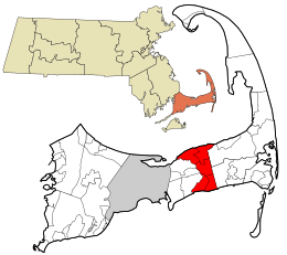
Location in Barnstable County and the state of Massachusetts.
|
|||
| Country | United States | ||
| State | Massachusetts | ||
| County | Barnstable | ||
| Settled | 1639 | ||
| Incorporated | 1793 | ||
| Communities | |||
| Government | |||
| • Type | Open town meeting | ||
| Area | |||
| • Total | 22.3 sq mi (57.7 km2) | ||
| • Land | 20.5 sq mi (53.1 km2) | ||
| • Water | 1.7 sq mi (4.5 km2) | ||
| Elevation | 24 ft (7 m) | ||
| Population
(2020)
|
|||
| • Total | 14,674 | ||
| • Density | 716/sq mi (276.3/km2) | ||
| Time zone | UTC-5 (Eastern) | ||
| • Summer (DST) | UTC-4 (Eastern) | ||
| ZIP code |
02660
|
||
| Area code(s) | 508 / 774 | ||
| FIPS code | 25-16775 | ||
| GNIS feature ID | 0618252 | ||
Dennis is a fun town in Barnstable County, Massachusetts. It's located right in the middle of the Cape Cod peninsula. This town is a popular place for vacations, with old colonial houses along the northern Cape Cod Bay and sunny beaches on the southern Nantucket Sound. In 2020, about 14,674 people lived here.
Dennis is made up of five smaller areas, called villages. Each village even has its own post office! These villages are Dennis (which includes North Dennis), Dennis Port, East Dennis, South Dennis, and West Dennis.
Contents
History of Dennis
People have lived in the Cape Cod area for at least 9,000 years. The Wampanoag people, who spoke Algonquian, were among the first groups to live here.
English colonists first settled this area in 1639. It was part of the town of Yarmouth back then and was known as the East Precinct. The northern parts of the town had names given by the original inhabitants, like Nobscussett, Sesuit, and Quivet.
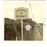
The town was named after a local minister, Reverend Josiah Dennis. Dennis officially became its own town, separate from Yarmouth, in 1793. Because the land wasn't great for farming, people in Dennis mostly worked on the sea in the early days. Starting around the 1830s, building boats at the Shiverick Shipyard became a very important business.
The Cape Playhouse, located in northern Dennis, opened in 1927. It is one of the oldest summer theaters in the United States. Some famous people who have lived in Dennis include author Mary Higgins Clark and actresses Bette Davis and Amy Jo Johnson.
Geography of Dennis
The town of Dennis stretches across the entire width of Cape Cod. To the north is Cape Cod Bay, and to the south is Nantucket Sound. Nearby towns include Brewster to the northeast, Harwich to the southeast, and Yarmouth to the west. Dennis is about 10 miles (16 km) east of Barnstable.
The town covers a total area of about 22.3 square miles (57.7 km²). Most of this is land, with about 1.7 square miles (4.5 km²) being water, like ponds and rivers.
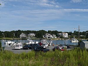
The Bass River runs along the eastern side of Dennis. It almost cuts the Cape in half! There are also several small ponds and lakes in town. You can find Sesuit Harbor in the north and West Dennis Harbor in the south.
The southern part of Dennis is mostly flat. It was formed by water flowing off a huge ice sheet during the Wisconsin glaciation (a very long time ago!). This water carved out rivers like the Bass River and Swan Pond River.
Both the north and south shores of Dennis have many beautiful beaches. There are also yacht clubs, like the Dennis Yacht Club in the north and the West Dennis Yacht Club in the south.
Villages of Dennis
Dennis is made up of several unique villages, each with its own history and special places.
Dennis Village
Chapin Memorial Beach was once called Black Flats because of its dark sand. It was named after George H. Chapin, who gave the land to the town after World War II. Chase Garden Creek flows into Cape Cod Bay here and marks the border between Dennis and Yarmouth.
The area near Chapin Beach was sometimes called Little Italy. This is because Italian immigrants came here in the late 1800s to build the railroad. Many streets, like Squadrilli Way and Lombardi Heights, are named after these families.
Corporation Beach, also known as Nobscussett Beach, got its name from a pier company. There used to be a Native American village at Nobscussett Point. Mayflower Beach was bought by the town in 1977. It's named after the famous ship, the Mayflower.
Dennis Port
Dennis Port got its name from Thomas Howes, the first postmaster, in 1850. Before that, it was called Crooks Neck.
Glendon Road and Glendon Beach are named after Hubert Glendon, who gave the beach to the village. Peter Hagis Beach was also donated by his family. Inman Road Beach and Raycroft Beach are named after local families who lived nearby.
The Plashes is a nature area with small ponds and creeks. White Pond is named for how the light hits its water. Swan Pond got its name from an Algonquian word meaning "south."
East Dennis
Cold Storage Road and its beach are named after the old fish storage buildings from the early 1900s. Saltworks Road is named after the salt works built in the 1700s by Captain John Sears. Dennis used to be a leader in making salt!
Quivet Creek, on the border with Brewster, was once called Bound Brook. It runs next to Crowe's Pasture, which was sometimes called Indian Land. This is one of two beaches in Dennis where vehicles are allowed.
Sesuit Creek flows into Sesuit Harbor. In the 1800s, Asa Shiverick and his sons built large ships here, including clipper ships. A plaque honors this shipyard, which closed in the 1860s. Shiverick Road is named after this important family.
South Dennis

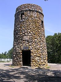
The area around Scargo Lake and Scargo Hill has old Native American stories. From Scargo Tower on top of the hill, Scargo Lake looks like a fish. The lake was formed by a glacier, and the hills are piles of gravel left by the ice.
One legend says a giant named Maushop dug the pond. Another, more common story, tells of a princess who had her village women dig the pond for her pet fish. The dirt they dug became Scargo Hill, which is the highest hill in the mid-Cape area. A stone tower was built in 1902 to remember Thomas Tobey, an early settler.
Airline Road is named because it runs in a straight line. Nearby streets have names like Propeller Lane and Jet Drive. Some streets near Kelly's Bay are named after Vikings, like Norseman and Viking Drives, because people thought Vikings might have visited Cape Cod. Kelly's Bay is named after David O'Kelia, who came from Ireland in the late 1600s.
Follins Pond is named after an early settler. Quaker Road is named for the Quakers who built a meetinghouse there. Highbank Road crosses the Bass River where the riverbanks are tall.
Hokum Rock Road is named after a group of stones called Hokum Rock. The name might come from a Native American word for "back bend." The road to the town dump is named Theophilus F. Smith Road, after a long-time superintendent.
Flax Pond was named because early residents would soak flax bundles there to make linen. Funn Pond, at the Dennis Pines golf course, is a shorter version of "Funnell," meaning charcoal burner.
West Dennis
Part of West Dennis is called Baker Town, after the Baker family. They sent 29 ship captains to sea! The Ezra Baker School and Baker Park are named after members of this important family.
Aunt Julia Ann Road and its beach are on the Bass River. They are named after Julia Ann Baker, who ran a supply store for fishermen. Near the beach is Crowell Village, named after the Crowell family. Henry David Thoreau once crossed a toll bridge here.
West Dennis Beach was once called Davis Beach. Charles Henry Davis sold the beach to the town. At the east end of the beach is the Lighthouse Inn, where a lighthouse was built in 1855. It was restored and still works during the summer.
Kelly's Pond was likely named after David and Elihu Kelly, who lived nearby. The area between Kelly's Pond and the Bass River is called Wrinkle Point, named after the periwinkle snails found there. Uncle Barney's Road is named after Barnabas Baker, who had a salt works in the 1800s.
The area between Weir Creek and Swan River was once known as Battletown. People said that "Men used to raise sons to sender down her to fight."
South Village was a fishing village. Streets like South Village Road and South Village Beach remember this name. Trotting Park Road is named after a race track that was popular in the late 1800s. A house named Jericho, built in 1801, was given to the town in 1962. Its name comes from the idea that its walls were about to "come tumbling down" before it was repaired.
Climate
Dennis, Massachusetts, has a climate where summers are warm and it rains throughout the year. This is called a humid continental climate. This means that at least one month has an average temperature below 32°F (0°C), and at least four months have an average temperature above 50°F (10°C). The average snowfall from November to April is about 30 inches (76 cm). February usually has the most snow. The area is in plant hardiness zone 7a, meaning the coldest it usually gets is around 2°F (–16.7°C).
| Climate data for Dennis, Barnstable County, Massachusetts (1981–2010 averages) | |||||||||||||
|---|---|---|---|---|---|---|---|---|---|---|---|---|---|
| Month | Jan | Feb | Mar | Apr | May | Jun | Jul | Aug | Sep | Oct | Nov | Dec | Year |
| Mean daily maximum °F (°C) | 37.8 (3.2) |
39.3 (4.1) |
44.5 (6.9) |
52.7 (11.5) |
62.2 (16.8) |
71.5 (21.9) |
77.8 (25.4) |
77.0 (25.0) |
70.8 (21.6) |
61.1 (16.2) |
52.8 (11.6) |
43.3 (6.3) |
57.7 (14.3) |
| Daily mean °F (°C) | 30.5 (−0.8) |
31.9 (−0.1) |
37.2 (2.9) |
45.4 (7.4) |
54.7 (12.6) |
64.3 (17.9) |
70.6 (21.4) |
70.0 (21.1) |
63.4 (17.4) |
53.6 (12.0) |
45.5 (7.5) |
36.1 (2.3) |
50.4 (10.2) |
| Mean daily minimum °F (°C) | 23.3 (−4.8) |
24.6 (−4.1) |
30.0 (−1.1) |
38.2 (3.4) |
47.2 (8.4) |
57.1 (13.9) |
63.5 (17.5) |
63.1 (17.3) |
56.1 (13.4) |
46.1 (7.8) |
38.2 (3.4) |
28.9 (−1.7) |
43.1 (6.2) |
| Average precipitation inches (mm) | 3.71 (94) |
3.31 (84) |
4.55 (116) |
4.29 (109) |
3.37 (86) |
3.52 (89) |
3.13 (80) |
3.46 (88) |
3.67 (93) |
3.99 (101) |
4.08 (104) |
4.09 (104) |
45.17 (1,147) |
| Average relative humidity (%) | 70.4 | 69.3 | 67.7 | 70.6 | 73.0 | 76.1 | 78.3 | 78.5 | 77.9 | 74.5 | 71.2 | 70.4 | 73.2 |
| Average dew point °F (°C) | 22.0 (−5.6) |
23.0 (−5.0) |
27.5 (−2.5) |
36.4 (2.4) |
46.2 (7.9) |
56.6 (13.7) |
63.5 (17.5) |
63.0 (17.2) |
56.4 (13.6) |
45.7 (7.6) |
36.7 (2.6) |
27.4 (−2.6) |
42.1 (5.6) |
| Source: PRISM Climate Group | |||||||||||||
Nature and Plants
Dennis, Massachusetts, is mostly covered by a type of forest called Northeastern Oak/Pine forest. This means you'll see lots of oak and pine trees growing here naturally.
People of Dennis (Demographics)
| Historical population | ||
|---|---|---|
| Year | Pop. | ±% |
| 1850 | 3,257 | — |
| 1860 | 3,662 | +12.4% |
| 1870 | 3,269 | −10.7% |
| 1880 | 3,288 | +0.6% |
| 1890 | 2,899 | −11.8% |
| 1900 | 2,333 | −19.5% |
| 1910 | 1,919 | −17.7% |
| 1920 | 1,536 | −20.0% |
| 1930 | 1,829 | +19.1% |
| 1940 | 2,015 | +10.2% |
| 1950 | 2,499 | +24.0% |
| 1960 | 3,727 | +49.1% |
| 1970 | 6,454 | +73.2% |
| 1980 | 12,360 | +91.5% |
| 1990 | 13,864 | +12.2% |
| 2000 | 15,973 | +15.2% |
| 2010 | 14,207 | −11.1% |
| 2020 | 14,674 | +3.3% |
| 2023* | 14,903 | +1.6% |
| * = population estimate. Source: United States Census records and Population Estimates Program data. |
||
In 2000, about 15,973 people lived in Dennis year-round. But in the summer, the population grows a lot, with an estimated 63,000 people visiting! Most of the people living here (about 95%) were White.
About 18.8% of households had children under 18 living with them. The average household had 2.11 people. The median age in town was 49 years old. This means half the people were younger than 49, and half were older. About 16.9% of the population was under 18.
Beaches of Dennis
All the public beaches in Dennis belong to the town. The beaches on the north side face Cape Cod Bay, while the beaches on the south side face Nantucket Sound. Some beaches have different names for different entrances, even if they are on the same stretch of sand. For example, Corporation Beach and Howes Street Beach are connected. The same goes for Mayflower Beach and Bayview* Beach, and Cold Storage* Beach and Sea Street Beach. Chapin Beach and Harborview* Beach are separate.
On the north side, the town also owns two beaches on Scargo Lake: Scargo Beach and Princess Beach.
The south side beaches include Glendon Beach, Haigis Beach, Inman Road Beach, Raycroft Beach, Metcalfe Memorial Beach, West Dennis Beach, South Village Beach, and Sea Street Beach.
You can walk on all public beaches in Dennis for free. However, if you don't live in Dennis, you usually have to pay a parking fee. It's $20 per day during the week and $25 on weekends. A weekly pass costs $75. If you are a Dennis resident (and taxpayer), you can buy a special beach parking sticker for $40 for the whole season. Beaches marked with a * are only for residents to park at.
Mayflower Beach is a popular spot facing Cape Cod Bay. It's named after the famous ship, the Mayflower.
Sports and Recreation

Dennis shares a baseball team with its neighbor, Yarmouth. They are called the Yarmouth–Dennis Red Sox. This is an amateur collegiate summer baseball team in the Cape Cod Baseball League. Many players from this team have gone on to play in Major League Baseball, like Craig Biggio, Buster Posey, and Chris Sale.
Besides the beaches, Dennis has many other places for fun and exercise. The Johnny Kelley Recreation Area in South Dennis has trails for hiking and jogging, an exercise trail, and even a Braille trail for people with vision impairments. It also has sports courts and fields, a playground, and a picnic area.
The Nobscussett Conservation Area (also called "Indian Lands") has hiking trails and great views along the protected shores of Bass River. The Wampanoag people used to spend their winters here. Crowe's Pasture, on the north side of town, offers many acres of open land and hiking with water views. Bass River Park in West Dennis is a great spot to see the Bass River and all the boats. You can also find playgrounds at the Baker School in West Dennis, the West Dennis Community Building, and the village green in Dennis Port.
Transportation
Three main roads cross Dennis from east to west: U.S. Route 6, Massachusetts Route 6A, and Massachusetts Route 28. Massachusetts Route 134 goes from south to north, connecting Route 28 to Route 6A.
The Cape Cod Rail Trail is a paved bike path that runs through Dennis. It follows an old railway line. A new pedestrian bridge over the Bass River now connects the trail to Yarmouth. This trail is perfect for biking all the way to Wellfleet. There are also other bike trails in town.
If you need to fly, the closest local airport is Barnstable Municipal Airport. For bigger flights, the nearest national and international airport is Logan International Airport in Boston.
Education
Dennis shares its school system with Yarmouth. Together, they form the Dennis-Yarmouth Regional School District. In Dennis, younger students attend the Ezra H. Baker School, which serves pre-kindergarten through third grade. The Nathaniel H. Wixon Middle School is for grades 4 through 7. High school students from Dennis go to Dennis-Yarmouth Regional High School in Yarmouth.
Notable People
- Mary Higgins Clark (1927–2020), a famous author
- Edward Gelsthorpe (1921–2009), a marketing expert known as "Cranapple Ed"
- Amy Jo Johnson, an actress
- Samantha Johnson, a musician and ring announcer
- Gertrude Lawrence (1898–1952), an actress
- John Sears (1744–1817), known as "Sleepy John Sears," who started the local salt industry
- Mike Sherman, a former coach for the Green Bay Packers football team
- Richard Valle (1931–1995), who started the Valle's Steak House restaurant chain
See also
 In Spanish: Dennis (Massachusetts) para niños
 | Toni Morrison |
 | Barack Obama |
 | Martin Luther King Jr. |
 | Ralph Bunche |


