
Eastern Cascades Slopes and Foothills facts for kids
Quick facts for kids Eastern Cascades Slopes and Foothills ecoregion |
|
|---|---|

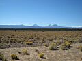
The Pumice Plateau, looking west toward the Oregon Cascade Volcanoes
|
|

Eastern Cascades Slopes and Foothills (9)
|
|
| Ecology | |
| Realm | Nearctic |
| Biome | Temperate coniferous forests |
| Borders |
List
|
| Geography | |
| Country | United States |
| States | Oregon, Washington and California |
| Coordinates | 44°00′N 122°00′W / 44.0°N 122.0°W |
The Eastern Cascades Slopes and Foothills ecoregion is a special natural area. It's found on the eastern side of the Cascade Range mountains. This region stretches across parts of Oregon, Washington, and California. The United States Environmental Protection Agency (EPA) officially named it.
Because it's in the 'rain shadow' of the Cascades, this area is much drier. It gets less rain and snow than the western side of the mountains. Temperatures here can also change a lot, from very hot to very cold.
You'll mostly see open forests of ponderosa pine and some lodgepole pine. This makes it different from the wetter Cascades ecoregion to the west, which has more hemlock and fir trees. To the east, it's drier still, with mostly shrubs and grasslands. The plants here are tough and can handle the dry, continental climate and frequent wildfires. You'll also see many volcanic cones and buttes.
The Eastern Cascades Slopes and Foothills ecoregion is divided into ten smaller areas. These are called Level IV ecoregions. We'll explore some of these unique areas in Washington and Oregon.
Contents
- Exploring the Eastern Cascades Slopes and Foothills
- Yakima Plateau and Slopes (9a)
- Grand Fir Mixed Forest (9b)
- Oak/Conifer Foothills (9c)
- Ponderosa Pine/Bitterbrush Woodland (9d)
- Pumice Plateau (9e)
- Cold Wet Pumice Plateau Basins (9f)
- Klamath/Goose Lake Warm Wet Basins (9g)
- Fremont Pine/Fir Forest (9h)
- Southern Cascades Slope (9i)
- Klamath Juniper Woodland (9j)
- Images for kids
Exploring the Eastern Cascades Slopes and Foothills

Yakima Plateau and Slopes (9a)
The Yakima Plateau and Slopes ecoregion is a high area that wasn't covered by glaciers. It has flat plateaus, hills called buttes, and deep canyons. Streams and rivers flow through these areas, some all year, some only part of the year. You can also find natural springs here.
This region is between 2,500 and 5,000 feet (760 to 1,500 meters) high. The dry climate supports open forests of ponderosa pine and bitterbrush. You might also see some Douglas fir and Oregon white oak. Wildfires are a natural part of this ecosystem. This area covers about 1,793 square miles (4,644 square kilometers) in Washington. Much of it belongs to the Yakama Nation.
Grand Fir Mixed Forest (9b)
The Grand Fir Mixed Forest ecoregion has high plateaus, mountains, and canyons. Glaciers once covered parts of this area. You'll find fast-flowing streams and rivers, and some lakes in rocky basins left by glaciers.
Elevations here range from 2,200 to 6,500 feet (670 to 2,000 meters). The cold soil and snowy climate are perfect for a mix of grand fir and Douglas-fir trees. There are also ponderosa pine and western larch. Smaller plants like vine maple, hazel, and snowberry grow underneath. This region is found on the eastern slopes of Mount Rainier, Mount Adams, and Mount Hood. It includes parts of national forests like Wenatchee and Deschutes.
Oak/Conifer Foothills (9c)
The Oak/Conifer Foothills ecoregion is lower and drier than the Grand Fir Mixed Forest. It has a wider variety of plants and animals. This area includes foothills, low mountains, plateaus, and valleys. It sits between 500 and 3,500 feet (150 to 1,100 meters) high.
Ocean winds blow into this region through the Columbia River Gorge. This makes the climate a mix of coastal and continental weather. You'll see Oregon white oak woodlands and ponderosa pine forests. In the west, there are Douglas-fir and western hemlock forests. Grasslands are also common. People use this land for forestry, recreation, and grazing animals. Farmers grow grain and hay in the valleys.
Ponderosa Pine/Bitterbrush Woodland (9d)
The Ponderosa Pine/Bitterbrush Woodland ecoregion has high, rolling volcanic plateaus and canyons. Streams here flow all year because of the volcanic rocks underground. This area is between 2,400 and 5,200 feet (730 to 1,600 meters) high.
The soil is made from ash from the Mount Mazama volcano, which erupted long ago. This soil is good for ponderosa pine trees. Historically, frequent fires kept these forests open. Underneath the trees, you'll find antelope bitterbrush, which deer eat in winter. Along streams, there are mountain alder and willows. This region is east of Mount Jefferson in Oregon.
Pumice Plateau (9e)
The Pumice Plateau ecoregion is a high volcanic plateau. It's covered by thick layers of ash and pumice from the Mount Mazama eruption. Elevations here range from 4,200 to 8,300 feet (1,300 to 2,500 meters).
The soil is very deep and lets water pass through easily, which can cause droughts. Streams are often small and fed by springs. It can freeze here at any time of year. Ponderosa pine forests grow on slopes. At higher elevations, you'll see white fir. In colder, flatter areas with thick pumice, lodgepole pine trees are common. This is the largest subregion of the Eastern Cascades. It's located in Oregon between Bend and Klamath Falls.
Cold Wet Pumice Plateau Basins (9f)
The Cold Wet Pumice Plateau Basins ecoregion includes areas like Sycan Marsh and Klamath Marsh. These basins are surrounded by the Pumice Plateau but are different. They are lower, from 4,100 to 5,200 feet (1,200 to 1,600 meters) high.
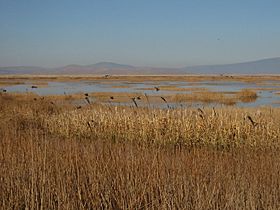
In winter, cold air settles in these basins, making them very chilly. The soil here often has water near the surface, unlike the drier Pumice Plateau. The La Pine Basin has thick lake deposits and high groundwater levels in spring. It has lodgepole pine forests and wet wetlands with lodgepole pine, willow, and aspen. The marshes have wetland plants like tules and tufted hairgrass. These marshes and lakes are important homes for migratory waterfowl.
Klamath/Goose Lake Warm Wet Basins (9g)
The Klamath/Goose Lake Warm Wet Basins ecoregion is named after Upper Klamath and Goose lakes. It's drier than other parts of the eastern Cascades. It has floodplains and old lake basins. Elevations are from 4,000 to 5,400 feet (1,200 to 1,600 meters).
This area once had many types of wildrye and bluegrass. But most of the wet meadows have been drained for homes, pastures, and farms. Now, people grow crops like alfalfa and potatoes here. You can still find plants like bluebunch wheatgrass and big sagebrush in the drier areas. Wetlands have tules and cattails. Several wildlife refuges in the Klamath Basin are important for protecting birds and fish.
Fremont Pine/Fir Forest (9h)
The Fremont Pine/Fir Forest ecoregion has mountains and high plateaus. They usually don't go above the tree line. Elevations range from 5,000 to 8,000 feet (1,500 to 2,400 meters).
The soil here is different from the Pumice Plateau because it's not buried by ash. There are reservoirs, some glacial lakes, and many springs. The climate and varied land support many plant types. Lower elevations have ponderosa pine and western juniper woodlands. Higher up, you'll find white fir, sugar pine, and whitebark pine. Understory plants include snowberry and antelope bitterbrush. This region is mostly public land within the Fremont-Winema National Forest.
Southern Cascades Slope (9i)
The Southern Cascades Slope ecoregion is a transition area. It connects the wetter Cascades ecoregion with the drier Eastern Cascade Slopes and Foothills. It has moderately sloping mountains with fast-flowing streams. Elevations are from 3,600 to 6,300 feet (1,100 to 1,900 meters).
This area is higher and gets more rain than other Eastern Cascades subregions. Ponderosa pine forests cover the mountains. At higher elevations, you'll see white fir, Shasta red fir, Douglas-fir, and incense cedar. Underneath, there are plants like Idaho fescue and snowberry. This region is south of Aspen Butte in Oregon.
Klamath Juniper Woodland (9j)
The Klamath Juniper Woodland ecoregion has rolling hills and cliffs. It's a mix of rangeland and woodland. Elevations are from 4,400 to 6,200 feet (1,300 to 1,900 meters). It gets about 12 to 20 inches (30 to 51 cm) of rain each year.
Western juniper trees grow on shallow, rocky soils. Underneath, you'll find low sagebrush, bitterbrush, and bunchgrasses. Some plants here are rare in eastern Oregon, like Klamath plum. These diverse shrublands are important homes for wildlife. Reservoirs in the area help with irrigation for farms. This region is south of Klamath Falls in Oregon.
Images for kids
-
The Pumice Plateau, looking west toward the Oregon Cascade Volcanoes
Flora
-
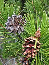
Lodgepole pine, subspecies known as Tamarack pine
-
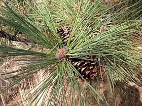
Ponderosa pine in the Klamath Marsh NWR
-
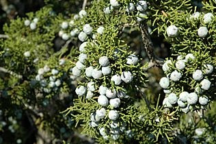
Western juniper berries


Fauna
-
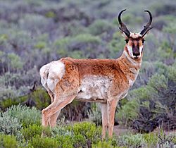
Pronghorn on the Pumice Plateau
-
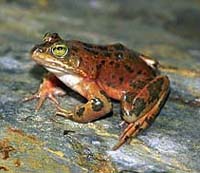
Oregon spotted frog, an endangered species candidate
-
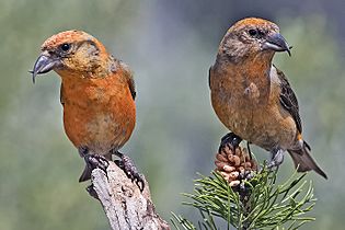
Red crossbills in Deschutes National Forest


.jpg)
Landscapes
-
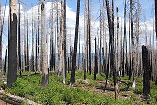
Lodgepole pine after wildfire in the Deschutes National Forest
-
Freshwater marsh in the Lower Klamath NWR
-
Canoe trail in the Upper Klamath NWR


