
Midlothian facts for kids
Quick facts for kids
|
|||
|---|---|---|---|
 |
|||
|
|||
| Country | Scotland | ||
| Lieutenancy area | Midlothian | ||
| Admin HQ | Dalkeith | ||
| Government | |||
| • Body | Midlothian Council | ||
| Area | |||
| • Total | 136.6 sq mi (353.7 km2) | ||
| Area rank | Ranked 21st | ||
| Population
(2020)
|
|||
| • Total | 91,340 | ||
| • Rank | Ranked 25th | ||
| • Density | 668.84/sq mi (258.24/km2) | ||
| ONS code | S12000019 | ||
| ISO 3166 code | GB-MLN | ||
| Largest town | Penicuik | ||

Midlothian is a special area in Scotland. It's known as a historic county, which means it has a long history. Today, it's one of 32 areas in Scotland used for local government. Midlothian is in the east-central Lowlands of Scotland. It shares borders with the City of Edinburgh council area, East Lothian, and the Scottish Borders.
Midlothian used to be much bigger in the Middle Ages, even including the city of Edinburgh. For a long time, it was officially called "shire of Edinburgh" or Edinburghshire. It bordered West Lothian, Lanarkshire, Peeblesshire, Selkirkshire, East Lothian, Berwickshire, and Roxburghshire. In the past, people worked in mining, farming, and fishing here. However, the modern Midlothian area no longer has a coastline.
Contents
History of Midlothian
_-_panoramio.jpg)
After the Roman Empire left Britain, the area now known as Lothian was home to ancient Britons who spoke a language called Brythonic. This land was part of a kingdom called Gododdin. In the 600s, a group called the Angles took over Gododdin. Lothian then became part of the kingdom of Bernicia, which later joined to form the Kingdom of Northumbria. Eventually, Lothian came under the control of the Scottish kings in the 900s.
Battles and Conflicts
During the Middle Ages, Lothian was a place where many battles happened between Scotland and England. One important fight was the Battle of Roslin in 1303. This battle took place at Roslin during the First War of Scottish Independence. A Scottish army, led by Simon Fraser and John Comyn, bravely defeated an English army.
Later, in the 1500s, the area was involved in a conflict called the Rough Wooing. During this time, Roslin Castle, which belonged to the Earl of Caithness, was destroyed in 1544 by forces sent by Henry VIII of England.
In the 1600s, Midlothian was part of the War of the Three Kingdoms. General George Monck used Dalkeith Castle as his base. He was the commander for the Commonwealth of England in Scotland. After the king returned to power, a local uprising called the "Pentland Rising" happened. It ended with the Battle of Rullion Green in 1666, where government forces won against rebels called Covenanters.
Modern Political Campaigns
A famous event in political history happened in Midlothian between 1878 and 1880. William Ewart Gladstone, a British Liberal politician, ran a special campaign here. It was one of the first modern political campaigns, where he traveled and spoke to many people. Gladstone won the Midlothian election and later became Prime Minister of the United Kingdom.
In 1978, Midlothian became a "Sister City" with Midlothian, Illinois in the United States. This means they have a special friendship and cultural exchange.
How Midlothian is Governed
Today, the Midlothian area is run by the Midlothian Council. Their main office is in Dalkeith.
From Shire to County
The exact beginning of Midlothian as a "shire" (an area controlled by a sheriff) is not fully clear. But we know it existed during the time of King David I (1124–1153). It covered the central part of an older region called Lothian. It was officially known as the "shire of Edinburgh" or "Edinburghshire," but the name "Midlothian" was also used very early on. The city of Edinburgh became its own separate administrative area in 1482.
In 1890, elected county councils were created in Scotland. The Midlothian County Council was formed, but it did not control the city of Edinburgh, which had its own town council. Even though the council called itself "Midlothian County Council," the official name of the county was still "county of Edinburgh" or "Edinburghshire." In 1913, the council asked the government to officially change the name to Midlothian. The government agreed to use the name Midlothian for all departments, but a formal legal change took longer. The name was finally changed by law in 1947.
The Midlothian County Council used to be based in the Midlothian County Buildings in Edinburgh.
Changes to Local Government
In 1975, the old county system was changed. Midlothian County Council was replaced by a new "district" called Midlothian. This new district was smaller than the old county. Some parts of the old Midlothian county went to other areas like Edinburgh, East Lothian, West Lothian, and the Scottish Borders.
The new Midlothian District Council set up its headquarters in Dalkeith. In 1991, they built a new main office called Midlothian House in Dalkeith.
Midlothian Today
In 1996, the system changed again, and Midlothian became a single "council area." This means it's now a self-governing area. The Midlothian Council still operates from Midlothian House in Dalkeith.
Geography of Midlothian

The Midlothian council area includes towns like Dalkeith, Bonnyrigg, and Penicuik. It also has part of the Pentland Hills Regional Park, the famous Rosslyn Chapel, and Dalkeith Palace.
The historic county of Midlothian has a shape like a trapezoid. It has a flat area along the Firth of Forth, which is very developed with many towns and the city of Edinburgh. As you go south, the land rises into hills. These include the Pentland Hills in the southwest, the Moorfoot Hills in the south-central part, and the Lammermuir Hills in the far southeast. The highest point in the historic county is Blackhope Scar, which is 651 meters (2,136 feet) high.
Midlothian doesn't have any large natural lakes. However, it has many reservoirs, which are artificial lakes built to store water. Some of the notable reservoirs include Gladhouse Reservoir, Rosebery Reservoir, and Glencorse Reservoir.
Towns and Villages in Midlothian

Here are some of the largest towns and villages in Midlothian by population:
| Settlement | Population (2020) |
|---|---|
| Bonnyrigg | 18320 |
| Penicuik | 16150 |
| Dalkeith | 14330 |
| Mayfield | 13690 |
| Gorebridge | 8040 |
| Loanhead | 6820 |
| Danderhall | 3160 |
| Rosewell | 2020 |
| Roslin | 1770 |
| Bilston | 1440 |
Places to Visit in Midlothian
- Arniston House
- Borthwick Castle
- Castlelaw Fort
- Crichton Castle
- Dalhousie Castle
- Dalkeith Palace
- Flotterstone
- Hawthornden Castle
- Midlothian Snowsports Centre, Hillend
- National Mining Museum
- Loanhead Memorial Park
- Mavisbank House
- Melville Castle
- Newbattle Abbey
- Pentland Hills
- Roslin Castle
- Roslin Glen Country Park
- Roslin Institute
- Rosslyn Chapel
- Tyne-Esk Walk
- Vogrie Country Park
- Wallace's Cave
Transportation in Midlothian
Midlothian has a good road network, including some smaller country roads. The Borders Railway train line connects Tweedbank to Edinburgh. It has four stations within Midlothian: Shawfair, Eskbank, Newtongrange, and Gorebridge.
Famous People from Midlothian
- William Drummond of Hawthornden (1585–1649), a Scottish poet.
- Princess Margaret of Scotland (1598–1600), daughter of King James VI and I (born at Dalkeith Palace).
- Sir Walter Scott (1771–1832), a famous writer who wrote the novel The Heart of Midlothian. He lived in Lasswade for several years.
- William Ewart Gladstone (1809–1898), a British Prime Minister who was a Member of Parliament for Midlothian.
- John Lawson Johnston (1839–1900), the person who created Bovril, was born in Roslin.
- Charles Thomson Rees Wilson (1869–1959) from Glencorse, a physicist who won a Nobel Prize.
- Annette Crosbie (born 1934), a well-known actress, was born in Gorebridge.
- Fish (singer) (born 1958), the former lead singer of the band Marillion.
- Gary Naysmith (born 1978) from Loanhead, a Scottish International Footballer who played for Heart of Midlothian and Everton.
- Darren Fletcher (born 1984) from Mayfield Dalkeith, a Scotland International footballer who captained his national team and won the UEFA Champions League with Manchester United.
- Steven Whittaker (born 1984) from Bonnyrigg, a Scotland International footballer.
Schools in Midlothian
Primary Schools
- Bilston Primary School, Bilston
- Bonnyrigg Primary School, Bonnyrigg
- Burnbrae Primary School, Hopefield
- Cornbank St James Primary School, Penicuik
- Cuiken Primary School, Penicuik
- Danderhall Primary School, Danderhall
- Gore Glen Primary School, Gorebridge
- Gorebridge Primary School, Gorebridge
- Hawthornden Primary School, Bonnyrigg
- King's Park Primary School, Dalkeith
- Lasswade Primary School, Lasswade
- Lawfield Primary School, Mayfield
- Loanhead Primary School, Loanhead
- Mauricewood Primary School, Penicuik
- Mayfield Primary School, Mayfield
- Moorfoot Primary School, North Middleton
- Newtongrange Primary School, Newtongrange
- Paradykes Primary School, Loanhead
- Rosewell Primary School, Rosewell
- Roslin Primary School, Roslin
- Sacred Heart RC Primary School, Penicuik
- St Andrews's RC Primary School Gorebridge
- St David's RC Primary School Dalkeith
- St Luke's RC Primary School, Mayfield
- St Margaret's RC Primary School, Loanhead
- St Mary's RC Primary School, Bonnyrigg
- St Matthew's RC Primary School, Rosewell
- Stobhill Primary School, Gorebridge
- Strathesk Primary School, Penicuik
- Tynewater Primary School, Pathhead
- Woodburn Primary School, Woodburn
Secondary Schools
- Beeslack High School, Penicuik
- Dalkeith High School, Dalkeith
- Lasswade High School Centre, Bonnyrigg
- Newbattle Community High School, Mayfield
- Penicuik High School, Penicuik
- St. David's RC High School, Dalkeith
Special Schools
- Saltersgate School, Dalkeith
- Top Services Pathhead
Sister Cities
Midlothian has special "sister city" relationships with other places around the world. This helps them share culture and ideas.
- Komárom-Esztergom, Hungary
- Kreis Heinsberg, Germany
- Midlothian, Illinois, USA (a suburb of Chicago)
Images for kids
-
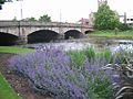
The historic Roman Bridge in Musselburgh, a town that was once part of Midlothian.
-
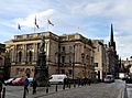
Lothian Chambers, which used to be the main office for Midlothian County Council.


See also
 In Spanish: Midlothian para niños
