Hopewell Township, Mercer County, New Jersey facts for kids
Quick facts for kids
Hopewell Township, New Jersey
|
||
|---|---|---|
|
Township
|
||
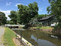
The Delaware and Raritan Canal at Washington Crossing in Hopewell Township
|
||
|
||

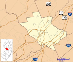
Location of Hopewell Township in Mercer County highlighted in red (right). Inset map: Location of Mercer County in New Jersey highlighted in orange (left).
|
||
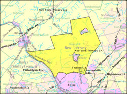
Census Bureau map of Hopewell Township, Mercer County, New Jersey
<mapframe text="Interactive map of Hopewell Township, New Jersey" zoom="8" width="250" height="250"> { "type": "ExternalData", "service": "geoshape", "ids": "Q5900433" } </mapframe> |
||
| Country | ||
| State | ||
| County | ||
| Founded | February 20, 1700 | |
| Royal charter | March 1, 1755 | |
| Incorporated | February 21, 1798 | |
| Government | ||
| • Type | Township | |
| • Body | Township Committee | |
| Area | ||
| • Total | 58.95 sq mi (152.67 km2) | |
| • Land | 58.07 sq mi (150.40 km2) | |
| • Water | 0.87 sq mi (2.26 km2) 1.48% | |
| Area rank | 22nd of 565 in state 1st of 12 in county |
|
| Elevation | 217 ft (66 m) | |
| Population
(2020)
|
||
| • Total | 17,491 | |
| • Estimate
(2023)
|
17,383 | |
| • Rank | 152nd of 565 in state 8th of 12 in county |
|
| • Density | 301.2/sq mi (116.3/km2) | |
| • Density rank | 473rd of 565 in state 12th of 12 in county |
|
| Time zone | UTC−05:00 (EST) | |
| • Summer (DST) | UTC−04:00 (EDT) | |
| ZIP Code |
08560 – Titusville
|
|
| Area code(s) | 609 exchanges: 730, 737, 18 | |
| FIPS code | 3402133180 | |
| GNIS feature ID | 0882129 | |
Hopewell Township is a community in Mercer County, New Jersey. It's located where the Delaware Valley meets the Raritan Valley. The township is considered a suburb of New York City. It also borders the Philadelphia area.
In 2020, Hopewell Township had a population of 17,491 people. This was the highest number of residents ever recorded for the township.
The township was first established on February 20, 1700. At that time, it was part of Burlington County. One of the first European settlers was George Woolsey, who arrived before 1710. His family kept their farm for over 200 years.
Hopewell Township was officially created by a special document called a Royal charter on March 1, 1755. It was later re-established by the New Jersey Legislature on February 21, 1798. This made it one of the first 104 townships in the state. In 1838, Hopewell Township became part of the newly formed Mercer County. Over the years, some parts of the township were used to create other towns, like Pennington and Hopewell Borough.
Contents
History of Hopewell Township
Hopewell Township is famous for a key event in American history. It's where George Washington and his Continental Army landed after crossing the Delaware River from Pennsylvania. This happened on December 26, 1776. After crossing, the army marched to Trenton, leading to the important Battle of Trenton. Today, Washington Crossing State Park remembers this moment.
In 1932, a significant historical event occurred in the township. The body of Charles Lindbergh Jr. was found here. He was the son of famous pilot Charles Lindbergh.
In May 2023, a rare event happened when a meteorite weighing 986 grams (34.8 oz) crashed through the roof of a home in the township. Scientists found it had a very low iron content, making it special.
Geography and Nature
Hopewell Township covers about 58.95 square miles (152.67 km2). Most of this area is land, with a small part being water.
The township has rolling hills and small mountains. The northern and western parts are covered by The Sourlands. The land becomes flatter towards the southeast. Baldpate Mountain is the highest point, at 480 feet (150 m) above sea level. The lowest areas are near Jacobs Creek where it meets the Delaware River.
Hopewell Township completely surrounds two other towns: Hopewell Borough and Pennington. This is a unique situation, as it's the only place in New Jersey that surrounds two other municipalities.
The township shares borders with several other communities. These include Ewing Township, Lawrence Township, and Princeton in Mercer County. It also borders towns in Hunterdon County, Somerset County, and even Pennsylvania across the Delaware River.
Many small communities and places are located within Hopewell Township. Some of these are Ackors Corner, Bear Tavern, Titusville, and Washington Crossing. Popular neighborhoods include Hopewell Hunt and Brandon Farms.
Population and People
| Historical population | |||
|---|---|---|---|
| Census | Pop. | %± | |
| 1790 | 2,320 | — | |
| 1810 | 2,565 | — | |
| 1820 | 2,881 | 12.3% | |
| 1830 | 3,154 | 9.5% | |
| 1840 | 3,205 | 1.6% | |
| 1850 | 3,698 | 15.4% | |
| 1860 | 3,900 | 5.5% | |
| 1870 | 4,276 | 9.6% | |
| 1880 | 4,462 | 4.3% | |
| 1890 | 4,338 | −2.8% | |
| 1900 | 3,360 | * | −22.5% |
| 1910 | 3,171 | * | −5.6% |
| 1920 | 3,249 | 2.5% | |
| 1930 | 3,907 | 20.3% | |
| 1940 | 3,738 | −4.3% | |
| 1950 | 4,731 | 26.6% | |
| 1960 | 7,818 | 65.3% | |
| 1970 | 10,030 | 28.3% | |
| 1980 | 10,893 | 8.6% | |
| 1990 | 11,590 | 6.4% | |
| 2000 | 16,105 | 39.0% | |
| 2010 | 17,304 | 7.4% | |
| 2020 | 17,491 | 1.1% | |
| 2023 (est.) | 17,383 | 0.5% | |
| Population sources: 1790–1920 1840 1850–1870 1850 1870 1880–1890 1890–1910 1910–1930 1940–2000 2000 2010 2020 * = Lost territory in previous decade |
|||
In 2010, Hopewell Township had 17,304 people living in 6,282 homes. About 39% of homes had children under 18. Most homes (69.1%) were married couples.
The population was mostly White (86.74%). About 8.89% were Asian, and 2.10% were Black or African American. People of Hispanic or Latino background made up 3.31% of the population.
The median age in the township was 44.4 years. This means half the people were older than 44.4 and half were younger. About 26.4% of the population was under 18 years old.
Parks and Recreation
Hopewell Township offers many places for outdoor fun and learning:
- Stony Brook-Millstone Watershed Association: This group works to protect water and land.
- Washington Crossing State Park: This large park covers 3,575 acres (1,447 ha). It remembers a key event of the American Revolution.
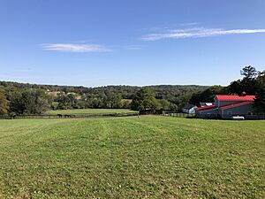
- St. Michaels Farm Preserve: This 400-acre (160 ha) area has farm fields and forests. It was first protected in 2010.
- Woolsey Park: Another great park for residents to enjoy.
Education in Hopewell Township
Students in Hopewell Township attend public schools in the Hopewell Valley Regional School District. This district serves students from Hopewell Borough, Hopewell Township, and Pennington Borough.
The district has six schools:
- Bear Tavern Elementary School (Pre-K–5)
- Hopewell Elementary School (Pre-K–5)
- Stony Brook Elementary School (K–5)
- Toll Gate Grammar School (K–5)
- Timberlane Middle School (6–8)
- Hopewell Valley Central High School (9–12)
In the 2019–20 school year, the district had 3,467 students. There was about one teacher for every 9.9 students. The school board has nine members, with Hopewell Township having seven seats.
Students in eighth grade from all of Mercer County can apply to special high school programs. These are offered by the Mercer County Technical Schools. They provide training in health sciences, STEM (Science, Technology, Engineering, Math), and culinary arts. There is no tuition fee for these programs.
Historic Places
The Pleasant Valley Historic District is a large area of 1,565-acre (633 ha). It includes historic buildings and sites. This district was added to the National Register of Historic Places in 1991. It is important for its history in farming, architecture, and early settlement.
A key part of this district is the Howell Living History Farm. This 130-acre (53 ha) farm is like an open-air museum. It shows what farm life was like around the year 1900. The farm was first bought in 1732 by Joseph Phillips, a blacksmith. The buildings you see today were built in the 1800s. The Howell family gave the farm to Mercer County in 1974 to be a museum.
Transportation and Roads
As of 2010, Hopewell Township had over 189 miles of roads. Most of these roads are maintained by the township itself.
Several major highways run through Hopewell Township:
- Route 29: This road runs along the Delaware and Raritan Canal in the southwestern part of the township.
- Route 31: This is the main north-south road.
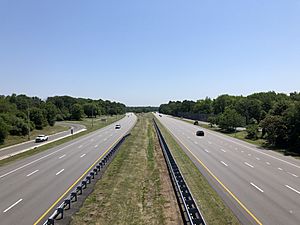
- Interstate 295: This highway passes through the southern part. It has two exits in the township.
Hopewell Township was once planned to be the start of a major highway called the Somerset Freeway. This freeway would have completed Interstate 95 in New Jersey. However, the project was canceled in 1982. In 2018, a change was made, and I-95 through Hopewell Township became I-295.
For public transportation, NJ Transit provides bus service. Route 624 connects the township to Trenton.
Climate and Environment
Hopewell Township has a climate with hot summers. The area gets a good amount of rain and snow throughout the year. Summers are warm, and winters are cold.
The natural plants in Hopewell Township would mostly be Oak trees. The area is part of the Eastern Hardwood Forest region.
Local Media
Hopewell Township has several local newspapers that keep residents informed:
- Hopewell Valley News
- Pennington Post
- Town Topics
- The Hopewell Sun
Winery
- Hopewell Valley Vineyards: A local vineyard where grapes are grown to make wine.
Notable People from Hopewell Township
Many interesting people have lived in or are connected to Hopewell Township:
- John Gano (1727–1804): A Baptist minister.
- Fred Green (1933–1996): A former professional baseball pitcher.
- John Hart (c. 1711–1779): A signer of the United States Declaration of Independence.
- Thomas Stoltz Harvey (1912–2007): A pathologist who performed the autopsy on Albert Einstein.
- Jean Hollander (1928–2019): A poet, translator, and teacher.
- Robert Hollander (1933–2021): An academic known for his work on Dante.
- Rush D. Holt Jr. (born 1948): A former U.S. Congressman.
- Robyn Jones (born 1985): A professional soccer goalkeeper.
- James W. Marshall (1810–1885): His discovery of gold started the California Gold Rush.
- Joyce Carol Oates (born 1938): A famous writer.
- Anne M. Patterson (born 1959): An Associate Justice of the New Jersey Supreme Court.
- Debbie Ryan (born 1952): A former college basketball coach.
- Suthan Suthersan (1956–2017): An environmental engineer.
- Anthony Verrelli (born 1964): A politician.
- Brandon Wagner (born 1995): A professional baseball player.
Images for kids
See also
 In Spanish: Municipio de Hopewell (condado de Mercer, Nueva Jersey) para niños


