Hamilton County, Indiana facts for kids
Quick facts for kids
Hamilton County
|
||
|---|---|---|

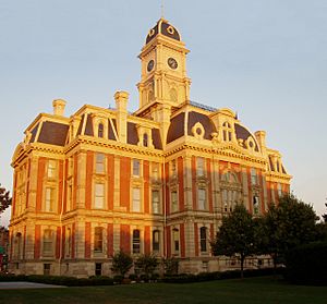
Hamilton County courthouse in Noblesville, Indiana
|
||
|
||

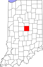
Location within the U.S. state of Indiana
|
||
 Indiana's location within the U.S. |
||
| Country | ||
| State | ||
| Founded | 1823 | |
| Named for | Alexander Hamilton | |
| Seat | Noblesville | |
| Largest city | Carmel | |
| Area | ||
| • Total | 402.44 sq mi (1,042.3 km2) | |
| • Land | 394.27 sq mi (1,021.2 km2) | |
| • Water | 8.17 sq mi (21.2 km2) 2.03%% | |
| Population
(2020)
|
||
| • Total | 347,467 | |
| • Estimate
(2023)
|
371,645 |
|
| • Density | 690/sq mi (266/km2) | |
| Time zone | UTC−5 (Eastern) | |
| • Summer (DST) | UTC−4 (EDT) | |
| Congressional district | 5th | |
|
||
Hamilton County is a county located in the state of Indiana in the United States. In 2020, about 347,467 people lived here. The main city and county seat is Noblesville.
Hamilton County is part of the larger Indianapolis area. Since the early 2000s, it has been the second most populated county in Central Indiana.
Originally, Hamilton County was mostly farmland. But after World War II, the area around Indianapolis grew, and many towns in Hamilton County became suburbs. This means more homes and businesses were built, replacing many farms. However, the northern part of the county still has a lot of farms.
In the 21st century, Hamilton County has become one of the fastest-growing counties in the U.S. Between 2000 and 2007, its population grew from about 182,740 to 261,661. By 2010, Hamilton County became the fourth most populated county in Indiana.
In 2020, three of Indiana's largest cities and towns were in Hamilton County: Carmel, Fishers, and Noblesville.
Two man-made lakes, Geist and Morse reservoirs, are in Hamilton County. They are popular for boating, fishing, and living by the water.
In 2008, Forbes.com called Hamilton County "America's Best Place to Raise a Family." This was because of its strong economy, good schools, and closeness to Indianapolis. The city of Carmel was named a top place to live by CNN Money in 2013. In 2017, Fishers was also named a best place to live.
Contents
History of Hamilton County
The land that is now Hamilton County became part of the United States in 1818 through the Treaty of St. Mary's. William Conner was the first white settler in the area.
In 1822, with enough settlers living there, Conner and others asked the Indiana Legislature to create a new county. The request was approved on January 8, 1823, and the county officially started on April 7, 1823. The first county leaders met at William Conner's house, which also served as the courthouse. The county was named after Alexander Hamilton, who was the first Secretary of the U.S. Treasury.
During the American Civil War, 2,165 soldiers from Hamilton County served. The last Civil War veteran living in the county passed away in 1942.
Many people from different backgrounds settled in Hamilton County. In the 1890s, a number of Belgian immigrants moved to the Noblesville area. Around the early 1900s, Serbian immigrants and their children also moved to towns like Arcadia, Carmel, Sheridan, Noblesville, and Cicero.
Many German-Americans also lived in Hamilton County. During World War I, there was a strong anti-German feeling in the county. For example, Wilhelm Street in Noblesville was renamed Washington Street. However, during World War II, Hamilton County was known for supporting the U.S. joining the war and helping Britain. This was different from many other parts of Indiana at the time, which preferred to stay neutral.
Climate and Weather
| Weather chart for Noblesville, Indiana | |||||||||||||||||||||||||||||||||||||||||||||||
|---|---|---|---|---|---|---|---|---|---|---|---|---|---|---|---|---|---|---|---|---|---|---|---|---|---|---|---|---|---|---|---|---|---|---|---|---|---|---|---|---|---|---|---|---|---|---|---|
| J | F | M | A | M | J | J | A | S | O | N | D | ||||||||||||||||||||||||||||||||||||
|
2.4
34
17
|
2.4
39
20
|
3.3
50
29
|
3.9
62
39
|
4.9
72
50
|
4.2
81
60
|
4.5
85
64
|
4.1
83
62
|
3.3
77
54
|
3
65
42
|
3.8
51
33
|
3.1
38
23
|
||||||||||||||||||||||||||||||||||||
| temperatures in °F precipitation totals in inches source: The Weather Channel |
|||||||||||||||||||||||||||||||||||||||||||||||
|
Metric conversion
|
|||||||||||||||||||||||||||||||||||||||||||||||
In Noblesville, the average temperatures change a lot throughout the year. In January, it can be as cold as 17 °F (−8 °C). In July, it can get as hot as 85 °F (29 °C). The coldest temperature ever recorded was −23 °F (−31 °C) in January 1994, and the hottest was 105 °F (41 °C) in July 1954.
The amount of rain and snow also varies. January usually gets about 2.42 inches (61 mm) of precipitation, while May gets the most, around 4.86 inches (123 mm). Hamilton County has a humid continental temperate climate. This means it has nice spring and fall seasons, but cold winters and hot, humid summers.
Geography
Hamilton County covers a total area of about 402.44 square miles (1,042.3 km2). Most of this area, about 394.27 square miles (1,021.2 km2), is land. The rest, about 8.17 square miles (21.2 km2), is water.
Major Highways
Airport
- KUMP - Indianapolis Metropolitan Airport
Adjacent Counties
Hamilton County shares borders with these other counties:
- Tipton County — North
- Madison County — East
- Hancock County — Southeast
- Marion County — South
- Boone County — West
- Clinton County — Northwest
Cities and Towns
These are the main cities and towns in Hamilton County:
Unincorporated Areas
These are smaller communities in Hamilton County that are not officially cities or towns:
- Aroma
- Bakers Corner
- Boxley
- Clare
- Clarksville
- Deming
- Durbin
- Eagletown
- Ekin
- Hortonville
- Lamong
- Luxhaven
- Millersburg
- New Britton
- Omega
- Riverwood
- Roberts Settlement
- Strawtown
- Walnut Grove
Townships
Hamilton County is divided into these smaller areas called townships:
- Adams
- Clay
- Delaware
- Fall Creek
- Jackson
- Noblesville
- Westfield Washington
- Wayne
- White River
Population and People
| Historical population | |||
|---|---|---|---|
| Census | Pop. | %± | |
| 1890 | 26,123 | — | |
| 1900 | 29,914 | 14.5% | |
| 1910 | 27,026 | −9.7% | |
| 1920 | 24,222 | −10.4% | |
| 1930 | 23,444 | −3.2% | |
| 1940 | 24,614 | 5.0% | |
| 1950 | 28,491 | 15.8% | |
| 1960 | 40,132 | 40.9% | |
| 1970 | 54,532 | 35.9% | |
| 1980 | 82,027 | 50.4% | |
| 1990 | 108,936 | 32.8% | |
| 2000 | 182,740 | 67.7% | |
| 2010 | 274,569 | 50.3% | |
| 2020 | 347,467 | 26.5% | |
| 2023 (est.) | 371,645 | 35.4% | |
| US Decennial Census 1790-1960 1900-1990 1990-2000 2010-2019 |
|||
2020 Census Information
In 2020, the population of Hamilton County was 347,467 people. Here's a look at the different groups living there:
| Race | Number of People | Percentage |
|---|---|---|
| White | 275,185 | 79.2% |
| Black or African American | 14,674 | 4.2% |
| Native American | 402 | 0.1% |
| Asian | 23,459 | 6.75% |
| Pacific Islander | 134 | 0.04% |
| Other/Mixed | 15,507 | 4.46% |
| Hispanic or Latino | 18,106 | 5.2% |
2010 Census Information
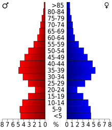
In 2010, there were 274,569 people living in Hamilton County. Most people (88.5%) were white. Other groups included Asian (4.8%), Black or African American (3.5%), and American Indian (0.2%). About 3.4% of the population was Hispanic or Latino.
The average age in the county was 35.6 years old. Many households (43.2%) had children under 18 living with them.
Life Expectancy
In 2010, people in Hamilton County lived for about 81.21 years on average. This was an increase from 76.16 years in 1980. The national average life expectancy in the U.S. in 2010 was 78.49 years.
Education
Hamilton County has several school districts that serve its communities:
- Carmel Clay Schools
- Hamilton Heights School Corporation
- Hamilton Southeastern Schools
- Sheridan Community Schools
- Noblesville Schools
- Westfield-Washington Schools
See also
 In Spanish: Condado de Hamilton (Indiana) para niños
 | Claudette Colvin |
 | Myrlie Evers-Williams |
 | Alberta Odell Jones |


