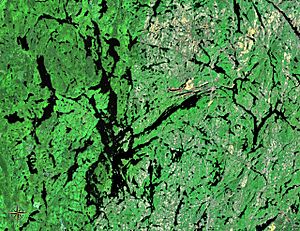
Temagami is vastly covered by lakes, of which
Lake Temagami (middle) is the largest
There are more than 200 named lakes located partially or entirely within the Municipality of Temagami, Northeastern Ontario, Canada. They are located in all 25 geographic townships comprising this 1,906.42 km2 (736.07 sq mi) municipality. The largest, by both area and volume, is Lake Temagami. It contains more than 1,200 islands and 1,000 km (620 mi) of shoreline. Other significant lakes include Cross Lake, Gull Lake, Net Lake, Obabika Lake and Rabbit Lake.
Temagami's lakes are situated in two watersheds. To the east, the Ottawa River basin drains lake water via the Matabitchuan River, which flows into Lake Timiskaming then enters the Ottawa River. The Great Lakes Basin to the west drains lake water via the Sturgeon River which flows into Lake Nipissing then enters the French River, eventually reaching Georgian Bay of Lake Huron.
The lakes are a main source of tourism and recreational activity in the Municipality of Temagami. This includes camping, canoeing, fishing, cottaging and youth camps (e.g. Keewaydin), as well as lodge and resort activity. The first recorded tourist was an oblate priest named Charles Paradis, who visited the area in July 1880 and eventually settled on Lake Temagami's Sandy Inlet. Despite its remote location and inaccessibility by rail until 1904, the Temagami area attracted increasing numbers of hardy tourists who arrived, as Paradis had done, by canoe from Lake Timiskaming in the east, or from the west travelling up the Sturgeon River from its intersection with the Canadian Pacific Railway. A wide variety of fish species are found in Temagami lakes, including walleye, smallmouth bass, lake trout, rainbow trout, brook trout, northern pike and perch.
List
The list is alphabetized by the name of the lake, with the words lake and the ignored. To sort on a different column, click on the arrows in the header row.
A
| Name |
Township(s) |
Coordinates |
NTS map |
Status |
CGNDB id |
| Aileen Lake |
Phyllis, Torrington, Vogt |
46°52′43″N 80°1′4″W / 46.87861°N 80.01778°W / 46.87861; -80.01778 |
041I/16 |
Official |
FABYR |
| Allan Lake |
Belfast |
47°1′6″N 80°12′20″W / 47.01833°N 80.20556°W / 47.01833; -80.20556 |
041P/01 |
Official |
FACLP |
| Alfreda Lake |
Strathy |
47°6′47″N 79°52′4″W / 47.11306°N 79.86778°W / 47.11306; -79.86778 |
031M/04 |
Official |
FACIT |
| Angus Lake |
Askin, Law |
46°53′49″N 79°45′35″W / 46.89694°N 79.75972°W / 46.89694; -79.75972 |
031L/13 |
Official |
FADEP |
| Anima Nipissing Lake |
Banting |
47°15′34″N 79°54′22″W / 47.25944°N 79.90611°W / 47.25944; -79.90611 |
031M/04 |
Official |
FADES |
| Arsenic Lake |
Strathy |
47°5′34″N 79°48′20″W / 47.09278°N 79.80556°W / 47.09278; -79.80556 |
031M/04 |
Official |
FADVE |
| Aston Lake |
Aston |
47°13′28″N 80°6′28″W / 47.22444°N 80.10778°W / 47.22444; -80.10778 |
041P/01 |
Official |
FEFVA |
B
| Name |
Township |
Coordinates |
NTS map |
Status |
CGNDB id |
| Banana Lake |
Belfast |
47°2′6″N 80°10′38″W / 47.03500°N 80.17722°W / 47.03500; -80.17722 |
041P/01 |
Official |
FAESC |
| Barmac Lake |
Aston |
47°10′26″N 80°5′51″W / 47.17389°N 80.09750°W / 47.17389; -80.09750 |
041P/01 |
Official |
FAFBA |
| Beach Lake |
Sisk |
46°44′10″N 79°47′46″W / 46.73611°N 79.79611°W / 46.73611; -79.79611 |
031L/12 |
Official |
FAFPT |
| Beaverpond Lake |
Banting |
47°9′9″N 80°0′29″W / 47.15250°N 80.00806°W / 47.15250; -80.00806 |
041P/01 |
Official |
FAGLY |
| Belanger Lake |
Olive |
46°49′39″N 79°49′35″W / 46.82750°N 79.82639°W / 46.82750; -79.82639 |
031L/13 |
Official |
FAGUA |
| Bernice Lake |
Strathy |
47°7′58″N 79°47′17″W / 47.13278°N 79.78806°W / 47.13278; -79.78806 |
031M/04 |
Official |
FAHIZ |
| Birch Lake |
Joan |
47°1′20″N 80°2′47″W / 47.02222°N 80.04639°W / 47.02222; -80.04639 |
041P/01 |
Official |
FAIRS |
| Black Duck Lake |
Best |
47°9′35″N 79°47′37″W / 47.15972°N 79.79361°W / 47.15972; -79.79361 |
031M/04 |
Official |
FAJKE |
| Blueberry Lake |
Cassels |
47°4′37″N 79°39′57″W / 47.07694°N 79.66583°W / 47.07694; -79.66583 |
031M/04 |
Official |
FAKCP |
| Bob Lake |
Canton |
47°10′23″N 80°15′45″W / 47.17306°N 80.26250°W / 47.17306; -80.26250 |
041P/01 |
Official |
FDJFT |
| Bogie Lake |
Cassels |
47°6′18″N 79°43′19″W / 47.10500°N 79.72194°W / 47.10500; -79.72194 |
031M/04 |
Official |
FDJIK |
| Boucher Lake |
Clement |
46°51′21″N 80°10′28″W / 46.85583°N 80.17444°W / 46.85583; -80.17444 |
041I/16 |
Official |
FAKTD |
| Boulton Lake |
Riddell |
47°0′28″N 79°42′2″W / 47.00778°N 79.70056°W / 47.00778; -79.70056 |
031M/04 |
Official |
FAKVF |
| Boyce Lake |
Milne |
46°50′2″N 79°37′48″W / 46.83389°N 79.63000°W / 46.83389; -79.63000 |
031L/13 |
Official |
FALCA |
| Breeches Lake |
Best |
47°14′3″N 79°52′38″W / 47.23417°N 79.87722°W / 47.23417; -79.87722 |
031M/04 |
Official |
FALLW |
| Broom Lake |
Briggs |
46°59′49″N 79°54′46″W / 46.99694°N 79.91278°W / 46.99694; -79.91278 |
031M/04 |
Official |
FALXQ |
| Brophy Lake |
Law |
46°56′0″N 79°49′20″W / 46.93333°N 79.82222°W / 46.93333; -79.82222 |
031L/13 |
Official |
FALXW |
| Browns Lake |
Cynthia |
47°6′57″N 80°5′18″W / 47.11583°N 80.08833°W / 47.11583; -80.08833 |
041P/01 |
Official |
FAMCR |
| Business Lake |
Chambers |
47°3′49″N 79°58′37″W / 47.06361°N 79.97694°W / 47.06361; -79.97694 |
031M/04 |
Official |
FANIZ |
C
| Name |
Township(s) |
Coordinates |
NTS map |
Status |
CGNDB id |
| Caribou Lake |
Strathcona, Strathy |
47°3′37″N 79°47′9″W / 47.06028°N 79.78583°W / 47.06028; -79.78583 |
031M/04 |
Official |
FAOUS |
| Carrying Lake |
Banting |
47°10′52″N 80°0′4″W / 47.18111°N 80.00111°W / 47.18111; -80.00111 |
031M/04 |
Official |
FAPCJ |
| Cassels Lake |
Cassels, Riddell |
47°4′9″N 79°43′10″W / 47.06917°N 79.71944°W / 47.06917; -79.71944 |
031M/04 |
Official |
FDJUY |
| Chambers Lake |
Chambers |
47°6′35″N 79°58′17″W / 47.10972°N 79.97139°W / 47.10972; -79.97139 |
031M/04 |
Official |
FAPVF |
| Charley Lake |
Chambers |
47°4′29″N 79°57′39″W / 47.07472°N 79.96083°W / 47.07472; -79.96083 |
031M/04 |
Official |
FAQAO |
| Chokecherry Lake |
Milne |
46°51′8″N 79°38′54″W / 46.85222°N 79.64833°W / 46.85222; -79.64833 |
031L/13 |
Official |
FAQRE |
| Christie Lake |
Sisk |
46°43′35″N 79°46′14″W / 46.72639°N 79.77056°W / 46.72639; -79.77056 |
031L/12 |
Official |
FAQTB |
| Christy Lake |
Law |
46°56′29″N 79°47′12″W / 46.94139°N 79.78667°W / 46.94139; -79.78667 |
031L/13 |
Official |
FAQTY |
| Clem Lake |
Vogt |
46°47′51″N 80°9′30″W / 46.79750°N 80.15833°W / 46.79750; -80.15833 |
041I/16 |
Official |
FAROK |
| Command Lake |
Briggs |
47°1′47″N 79°56′57″W / 47.02972°N 79.94917°W / 47.02972; -79.94917 |
031M/04 |
Official |
FASLI |
| Conross Lake |
Sisk |
46°44′45″N 79°45′37″W / 46.74583°N 79.76028°W / 46.74583; -79.76028 |
031L/12 |
Official |
FASRR |
| Contact Lake |
Banting |
47°10′7″N 79°56′34″W / 47.16861°N 79.94278°W / 47.16861; -79.94278 |
031M/04 |
Official |
FASSZ |
| Cooke Lake |
Strathy |
47°5′15″N 79°50′25″W / 47.08750°N 79.84028°W / 47.08750; -79.84028 |
031M/04 |
Official |
FASUH |
| Coppersand Lake |
Askin |
47°8′44″N 80°3′47″W / 47.14556°N 80.06306°W / 47.14556; -80.06306 |
041P/01 |
Official |
FATAI |
| Crash Lake |
Chambers |
47°5′58″N 79°56′17″W / 47.09944°N 79.93806°W / 47.09944; -79.93806 |
031M/04 |
Official |
FAUAG |
| Crest Lake |
Scholes |
46°55′38″N 80°12′23″W / 46.92722°N 80.20639°W / 46.92722; -80.20639 |
041I/16 |
Official |
FAUFK |
| Cross Lake |
Torrington, Yates |
46°52′18″N 79°57′58″W / 46.87167°N 79.96611°W / 46.87167; -79.96611 |
031L/13 |
Official |
FAUNF |
| Cummings Lake |
Scholes |
46°56′56″N 80°12′18″W / 46.94889°N 80.20500°W / 46.94889; -80.20500 |
041I/16 |
Official |
FAUXP |
D
| Name |
Township(s) |
Coordinates |
NTS map |
Status |
CGNDB id |
| Dean Lake |
Phyllis |
46°55′33″N 80°8′13″W / 46.92583°N 80.13694°W / 46.92583; -80.13694 |
041I/16 |
Official |
FAVWD |
| Denedus Lake |
Yates |
46°57′7″N 79°55′26″W / 46.95194°N 79.92389°W / 46.95194; -79.92389 |
031L/13 |
Official |
FAWJJ |
| Diamond Lake |
Canton |
47°12′16″N 80°14′51″W / 47.20444°N 80.24750°W / 47.20444; -80.24750 |
041P/01 |
Official |
FDJRT |
| Doris Lake |
Strathy |
47°5′12″N 79°51′8″W / 47.08667°N 79.85222°W / 47.08667; -79.85222 |
031M/04 |
Official |
FAZJG |
| Driftwood Lake |
Briggs, Strathcona |
46°58′55″N 79°52′47″W / 46.98194°N 79.87972°W / 46.98194; -79.87972 |
031L/13 |
Official |
FAZTP |
| Duncan Lake |
Best, Cassels |
47°8′45″N 79°44′55″W / 47.14583°N 79.74861°W / 47.14583; -79.74861 |
031M/04 |
Official |
FBAKH |
| Dwy Lake |
Law, Olive |
46°53′18″N 79°48′59″W / 46.88833°N 79.81639°W / 46.88833; -79.81639 |
031L/13 |
Official |
FBASE |
E
| Name |
Township |
Coordinates |
NTS map |
Status |
CGNDB id |
| Echo Lake |
Clement |
46°49′7″N 80°10′44″W / 46.81861°N 80.17889°W / 46.81861; -80.17889 |
041I/16 |
Official |
FBBPE |
| Eye Lake |
LeRoche |
47°3′52″N 80°9′58″W / 47.06444°N 80.16611°W / 47.06444; -80.16611 |
041P/01 |
Official |
FBDFP |
F
| Name |
Township |
Coordinates |
NTS map |
Status |
CGNDB id |
| Ferguson Lake |
Strathy |
47°8′21″N 79°45′46″W / 47.13917°N 79.76278°W / 47.13917; -79.76278 |
031M/04 |
Official |
FBDXP |
| Ferrim Lake |
Cynthia |
47°4′55″N 80°0′57″W / 47.08194°N 80.01583°W / 47.08194; -80.01583 |
041P/01 |
Official |
FEIOK |
| Flapjack Lake |
Sisk |
46°47′49″N 79°48′42″W / 46.79694°N 79.81167°W / 46.79694; -79.81167 |
031L/13 |
Official |
FBEEJ |
| Florence Lake |
Sisk |
46°44′40″N 79°51′3″W / 46.74444°N 79.85083°W / 46.74444; -79.85083 |
031L/12 |
Official |
FBELS |
| Foley Lake |
Briggs |
47°2′17″N 79°57′53″W / 47.03806°N 79.96472°W / 47.03806; -79.96472 |
031M/04 |
Official |
FBEQK |
| Frances Lake |
Milne |
46°50′45″N 79°40′25″W / 46.84583°N 79.67361°W / 46.84583; -79.67361 |
031L/13 |
Official |
FBFKS |
| Frawley Lake |
Sisk |
46°45′0″N 79°49′35″W / 46.75000°N 79.82639°W / 46.75000; -79.82639 |
031L/12 |
Official |
FBFRB |
| Friday Lake |
Best |
47°12′41″N 79°29′12″W / 47.21139°N 79.48667°W / 47.21139; -79.48667 |
031M/04 |
Official |
FBFYE |
G
| Name |
Township(s) |
Coordinates |
NTS map |
Status |
CGNDB id |
| Geoffrey Lake |
Banting |
47°12′48″N 79°54′16″W / 47.21333°N 79.90444°W / 47.21333; -79.90444 |
031M/04 |
Official |
FBGZM |
| Gilbert Lake |
Banting |
47°12′20″N 79°54′23″W / 47.20556°N 79.90639°W / 47.20556; -79.90639 |
031M/04 |
Official |
FBHIR |
| Goethe Lake |
Best |
47°12′54″N 79°46′22″W / 47.21500°N 79.77278°W / 47.21500; -79.77278 |
031M/04 |
Official |
FBIBD |
| Gosselin Lake |
Cassels |
47°5′45″N 79°41′53″W / 47.09583°N 79.69806°W / 47.09583; -79.69806 |
031M/04 |
Official |
FBIPR |
| Goward Lake |
Strathy |
47°5′49″N 79°48′47″W / 47.09694°N 79.81306°W / 47.09694; -79.81306 |
031M/04 |
Official |
FBITT |
| Granite Lake |
Best |
47°9′53″N 79°44′50″W / 47.16472°N 79.74722°W / 47.16472; -79.74722 |
031M/04 |
Official |
FBJAC |
| Gravel Pit Pond |
Law |
46°56′11″N 79°45′35″W / 46.93639°N 79.75972°W / 46.93639; -79.75972 |
031L/13 |
Official |
FBJJY |
| Greenlaw Lake |
Law |
46°56′22″N 79°50′44″W / 46.93944°N 79.84556°W / 46.93944; -79.84556 |
031L/13 |
Official |
FBJWB |
| Greyowl Lake |
LeRoche |
47°4′53″N 80°11′25″W / 47.08139°N 80.19028°W / 47.08139; -80.19028 |
041P/01 |
Official |
FBKDA |
| Gull Lake |
Clement, Joan, Phyllis, Scholes |
46°55′19″N 80°11′6″W / 46.92194°N 80.18500°W / 46.92194; -80.18500 |
041I/16 |
Official |
FBKOP |
| Guppy Lake |
Banting, Chambers |
47°8′22″N 79°59′35″W / 47.13944°N 79.99306°W / 47.13944; -79.99306 |
031M/04 |
Official |
FBKTR |
H
| Name |
Township(s) |
Coordinates |
NTS map |
Status |
CGNDB id |
| Hangstone Lake |
Olive, Torrington |
46°49′12″N 79°53′24″W / 46.82000°N 79.89000°W / 46.82000; -79.89000 |
031L/13 |
Official |
FBLOY |
| Hansen Lake |
Chambers |
47°7′13″N 79°55′5″W / 47.12028°N 79.91806°W / 47.12028; -79.91806 |
031M/04 |
Official |
FBLQW |
| Hardwood Lake |
Briggs |
47°0′24″N 79°59′8″W / 47.00667°N 79.98556°W / 47.00667; -79.98556 |
031M/04 |
Official |
FBLUW |
| Hay Lake |
Briggs |
47°1′6″N 79°56′36″W / 47.01833°N 79.94333°W / 47.01833; -79.94333 |
031M/04 |
Official |
FBMOW |
| Herbert Lake |
Joan |
46°58′48″N 80°8′17″W / 46.98000°N 80.13806°W / 46.98000; -80.13806 |
041I/16 |
Official |
FBNGB |
| Herridge Lake |
Law, Strathcona |
46°58′57″N 79°49′30″W / 46.98250°N 79.82500°W / 46.98250; -79.82500 |
031L/13 |
Official |
FBNIM |
| Hillcrest Lake |
Joan |
47°0′52″N 80°3′24″W / 47.01444°N 80.05667°W / 47.01444; -80.05667 |
041P/01 |
Official |
FBNVE |
| Hook Lake |
Strathy |
47°8′10″N 79°50′47″W / 47.13611°N 79.84639°W / 47.13611; -79.84639 |
031M/04 |
Official |
FBOPB |
| Hornet Lake |
Askin |
46°56′26″N 79°44′54″W / 46.94056°N 79.74833°W / 46.94056; -79.74833 |
031L/13 |
Official |
FBOUY |
| Hush Hush Lake |
Cynthia |
47°8′12″N 80°2′54″W / 47.13667°N 80.04833°W / 47.13667; -80.04833 |
041P/01 |
Official |
FBPRO |
I
| Name |
Township |
Coordinates |
NTS map |
Status |
CGNDB id |
| Iceland Lake |
Strathcona |
46°59′47″N 79°51′56″W / 46.99639°N 79.86556°W / 46.99639; -79.86556 |
031L/13 |
Official |
FBPWA |
| Indigo Lake |
Joan |
47°2′56″N 80°3′16″W / 47.04889°N 80.05444°W / 47.04889; -80.05444 |
041P/01 |
Official |
FBQEA |
| Ingall Lake |
Law |
46°54′38″N 79°46′39″W / 46.91056°N 79.77750°W / 46.91056; -79.77750 |
031L/13 |
Official |
FBQEI |
| Iron Lake |
Chambers |
47°4′0″N 79°55′0″W / 47.06667°N 79.91667°W / 47.06667; -79.91667 |
031M/04 |
Rescinded |
FBQMW |
J
| Name |
Township(s) |
Coordinates |
NTS map |
Status |
CGNDB id |
| Jackpine Lake |
Banting, Chambers |
47°8′44″N 79°56′3″W / 47.14556°N 79.93417°W / 47.14556; -79.93417 |
031M/04 |
Official |
FBRBM |
| James Lake |
Best |
47°10′41″N 79°44′26″W / 47.17806°N 79.74056°W / 47.17806; -79.74056 |
031M/04 |
Official |
FBRHD |
| Jamieson Lake |
Banting |
47°9′22″N 79°59′37″W / 47.15611°N 79.99361°W / 47.15611; -79.99361 |
031M/04 |
Official |
FBRHY |
| Jessie Lake |
Strathcona |
47°2′28″N 79°48′14″W / 47.04111°N 79.80389°W / 47.04111; -79.80389 |
031M/04 |
Official |
FBRSJ |
| Jumping Cariboo Lake |
Law, Olive |
46°52′57″N 79°46′32″W / 46.88250°N 79.77556°W / 46.88250; -79.77556 |
031L/13 |
Official |
FBSOZ |
| Jumpingcat Lake |
Belfast, Joan |
47°1′48″N 80°9′59″W / 47.03000°N 80.16639°W / 47.03000; -80.16639 |
041P/01 |
Official |
FBSPA |
K
| Name |
Township(s) |
Coordinates |
NTS map |
Status |
CGNDB id |
| Kanichee Lake |
Strathy |
47°7′15″N 79°50′12″W / 47.12083°N 79.83667°W / 47.12083; -79.83667 |
031M/04 |
Official |
FBSZO |
| Karol Lake |
Strathcona |
47°1′17″N 79°48′45″W / 47.02139°N 79.81250°W / 47.02139; -79.81250 |
031M/04 |
Official |
FBTCJ |
| Kettle Lake |
Milne, Olive |
46°52′14″N 79°45′2″W / 46.87056°N 79.75056°W / 46.87056; -79.75056 |
031L/13 |
Official |
FBUFR |
| Kokoko Lake |
Cynthia |
47°5′20″N 80°2′11″W / 47.08889°N 80.03639°W / 47.08889; -80.03639 |
041P/01 |
Official |
FBVHK |
L
| Name |
Township(s) |
Coordinates |
NTS map |
Status |
CGNDB id |
| Lambert Lake |
Milne |
46°48′32″N 79°44′7″W / 46.80889°N 79.73528°W / 46.80889; -79.73528 |
031L/13 |
Official |
FBWAW |
| Laroche Lake |
Sisk |
46°44′15″N 79°46′34″W / 46.73750°N 79.77611°W / 46.73750; -79.77611 |
031L/12 |
Official |
FBWJC |
| Le Roche Lake |
LeRoche |
47°3′58″N 80°12′46″W / 47.06611°N 80.21278°W / 47.06611; -80.21278 |
041P/01 |
Official |
FBXHS |
| Lenore Lake |
Banting |
47°9′0″N 79°57′48″W / 47.15000°N 79.96333°W / 47.15000; -79.96333 |
031M/04 |
Official |
FBXFY |
| Leroy Lake |
Cassels |
47°4′35″N 79°44′31″W / 47.07639°N 79.74194°W / 47.07639; -79.74194 |
031M/04 |
Official |
FBXHX |
| Liberty Lake |
Aston |
47°10′56″N 80°3′37″W / 47.18222°N 80.06028°W / 47.18222; -80.06028 |
041P/01 |
Official |
FBXLX |
| Link Lake |
Strathy |
47°4′18″N 79°49′4″W / 47.07167°N 79.81778°W / 47.07167; -79.81778 |
031M/04 |
Official |
FBXVF |
| Little Donald Lake |
Vogt |
46°49′37″N 80°6′17″W / 46.82694°N 80.10472°W / 46.82694; -80.10472 |
041I/16 |
Official |
FBYJB |
| Longbow Lake |
Joan, Scholes |
46°57′52″N 80°10′10″W / 46.96444°N 80.16944°W / 46.96444; -80.16944 |
041I/16 |
Official |
FCAHZ |
| Lowell Lake |
Strathcona |
47°0′35″N 79°47′58″W / 47.00972°N 79.79944°W / 47.00972; -79.79944 |
031M/04 |
Official |
FCBPD |
| Lower Bass Lake |
Belfast |
46°59′2″N 80°12′34″W / 46.98389°N 80.20944°W / 46.98389; -80.20944 |
041I/16 |
Official |
FCBPL |
| Lower Redwater Lake |
Askin, Milne |
46°53′3″N 79°38′2″W / 46.88417°N 79.63389°W / 46.88417; -79.63389 |
031L/13 |
Official |
FCBUH |
| Lower Twin Lake |
Riddell |
46°58′47″N 79°44′14″W / 46.97972°N 79.73722°W / 46.97972; -79.73722 |
031L/13 |
Official |
FCBVV |
| Lowery Lake |
Torrington |
46°51′40″N 79°53′21″W / 46.86111°N 79.88917°W / 46.86111; -79.88917 |
031L/13 |
Official |
FCBWK |
| Lundy Lake |
Banting |
47°11′24″N 79°54′37″W / 47.19000°N 79.91028°W / 47.19000; -79.91028 |
031M/04 |
Official |
FCCDH |
M
| Name |
Township |
Coordinates |
NTS map |
Status |
CGNDB id |
| Maille Lake |
Strathcona |
47°0′59″N 79°48′42″W / 47.01639°N 79.81167°W / 47.01639; -79.81167 |
031M/04 |
Official |
FDQRG |
| Malloch Lake |
Cynthia |
47°4′43″N 80°3′4″W / 47.07861°N 80.05111°W / 47.07861; -80.05111 |
041P/01 |
Official |
FCDFN |
| Mann Lake |
Olive |
46°51′48″N 79°50′51″W / 46.86333°N 79.84750°W / 46.86333; -79.84750 |
031L/13 |
Official |
FDKNP |
| Mannajigama Lake |
Banting |
47°13′43″N 79°54′23″W / 47.22861°N 79.90639°W / 47.22861; -79.90639 |
031M/04 |
Official |
FDKNE |
| Marian Lake |
Sisk |
46°46′18″N 79°47′6″W / 46.77167°N 79.78500°W / 46.77167; -79.78500 |
031L/13 |
Official |
FDNDE |
| Marten Lake |
Sisk |
46°42′13″N 79°43′43″W / 46.70361°N 79.72861°W / 46.70361; -79.72861 |
031L/12 |
Official |
FCDPG |
| Maureen Lake |
Strathy |
47°6′0″N 79°51′49″W / 47.10000°N 79.86361°W / 47.10000; -79.86361 |
031M/04 |
Official |
FCECO |
| McAdam Lake |
Torrington |
46°52′16″N 79°55′31″W / 46.87111°N 79.92528°W / 46.87111; -79.92528 |
031L/13 |
Official |
FCEHD |
| McCarthy Lake |
Belfast |
47°0′23″N 80°10′19″W / 47.00639°N 80.17194°W / 47.00639; -80.17194 |
041P/01 |
Official |
FCEJX |
| McLaren Lake |
Briggs |
47°1′29″N 79°57′56″W / 47.02472°N 79.96556°W / 47.02472; -79.96556 |
031M/04 |
Official |
FDPIA |
| McLean Lake |
Banting |
47°11′41″N 79°58′22″W / 47.19472°N 79.97278°W / 47.19472; -79.97278 |
031M/04 |
Official |
FDPJN |
| McNab Lake |
Best |
47°9′48″N 79°40′18″W / 47.16333°N 79.67167°W / 47.16333; -79.67167 |
031M/04 |
Official |
FDPNG |
| Milne Lake |
Milne |
46°49′11″N 79°41′57″W / 46.81972°N 79.69917°W / 46.81972; -79.69917 |
031L/13 |
Official |
FDUWT |
| Monty Lake |
Cassels |
47°8′0″N 79°43′42″W / 47.13333°N 79.72833°W / 47.13333; -79.72833 |
031M/04 |
Official |
FDVPY |
| Moon Lake |
Sisk |
46°43′15″N 79°51′34″W / 46.72083°N 79.85944°W / 46.72083; -79.85944 |
031L/12 |
Official |
FCESF |
| Moosehead Lake |
Belfast |
47°0′59″N 80°10′39″W / 47.01639°N 80.17750°W / 47.01639; -80.17750 |
041P/01 |
Official |
FDWHE |
| Mountain Lake |
Best |
47°13′51″N 79°49′56″W / 47.23083°N 79.83222°W / 47.23083; -79.83222 |
031M/04 |
Official |
FCEYN |
| Myth Lake |
Best |
47°8′54″N 79°38′4″W / 47.14833°N 79.63444°W / 47.14833; -79.63444 |
031M/04 |
Official |
FDLLR |
N
| Name |
Township(s) |
Coordinates |
NTS map |
Status |
CGNDB id |
| Nellem Lake |
Chambers |
47°6′10″N 79°57′53″W / 47.10278°N 79.96472°W / 47.10278; -79.96472 |
031M/04 |
Official |
FDMYM |
| Net Lake |
Best, Cassels, Strathy |
47°6′58″N 79°47′15″W / 47.11611°N 79.78750°W / 47.11611; -79.78750 |
031M/04 |
Official |
FDONK |
| Norris Lake |
Olive |
46°51′19″N 79°52′10″W / 46.85528°N 79.86944°W / 46.85528; -79.86944 |
031L/13 |
Official |
FDYMX |
| North Milne Lake |
Law |
46°57′22″N 79°47′1″W / 46.95611°N 79.78361°W / 46.95611; -79.78361 |
031L/13 |
Official |
FCGEC |
O
| Name |
Township(s) |
Coordinates |
NTS map |
Status |
CGNDB id |
| Obabika Lake |
Belfast, LeRoche |
47°2′37″N 80°15′16″W / 47.04361°N 80.25444°W / 47.04361; -80.25444 |
041P/01 |
Official |
FCGLS |
| Obashkong Lake |
Cassels |
47°6′36″N 79°39′54″W / 47.11000°N 79.66500°W / 47.11000; -79.66500 |
031M/04 |
Official |
FCGMH |
| O'Connor Lake |
Chambers, Strathy |
47°4′15″N 79°52′48″W / 47.07083°N 79.88000°W / 47.07083; -79.88000 |
031M/04 |
Official |
FCGOY |
| Olier Lake |
Yates |
46°57′42″N 79°56′20″W / 46.96167°N 79.93889°W / 46.96167; -79.93889 |
031L/13 |
Official |
FCGXN |
| Olive Lake |
Olive |
46°48′39″N 79°48′46″W / 46.81083°N 79.81278°W / 46.81083; -79.81278 |
031L/13 |
Official |
FCGXX |
| Opechee Lake |
Sisk |
46°46′57″N 79°49′40″W / 46.78250°N 79.82778°W / 46.78250; -79.82778 |
031L/13 |
Official |
FENBI |
| Opechee Boys Lake |
Olive, Sisk |
46°47′44″N 79°49′57″W / 46.79556°N 79.83250°W / 46.79556; -79.83250 |
031L/13 |
Official |
FENBF |
| Owaissa Lake |
Best |
47°9′10″N 79°46′39″W / 47.15278°N 79.77750°W / 47.15278; -79.77750 |
031M/04 |
Official |
FDPVQ |
P
| Name |
Township(s) |
Coordinates |
NTS map |
Status |
CGNDB id |
| Packsack Lake |
Olive |
46°51′18″N 79°45′59″W / 46.85500°N 79.76639°W / 46.85500; -79.76639 |
031L/13 |
Official |
FDPZX |
| Pan Lake |
Olive |
46°50′29″N 79°47′52″W / 46.84139°N 79.79778°W / 46.84139; -79.79778 |
031L/13 |
Official |
FDRDZ |
| Pancake Lake |
Milne |
46°52′30″N 79°45′12″W / 46.87500°N 79.75333°W / 46.87500; -79.75333 |
031L/13 |
Official |
FDRDJ |
| Panet Lake |
Milne |
46°48′5″N 79°44′54″W / 46.80139°N 79.74833°W / 46.80139; -79.74833 |
031L/13 |
Official |
FDRDT |
| Pat Lake |
Vogt |
46°50′20″N 80°5′16″W / 46.83889°N 80.08778°W / 46.83889; -80.08778 |
041I/16 |
Official |
FCHEF |
| Pats Lake |
Phyllis, Vogt |
46°53′8″N 80°2′6″W / 46.88556°N 80.03500°W / 46.88556; -80.03500 |
041I/16 |
Official |
FCHFA |
| Petraut Lake |
Best |
47°8′59″N 79°43′47″W / 47.14972°N 79.72972°W / 47.14972; -79.72972 |
031M/04 |
Official |
FDOWX |
| Pig Lake |
Law |
46°56′2″N 79°47′52″W / 46.93389°N 79.79778°W / 46.93389; -79.79778 |
031L/13 |
Official |
FDQLE |
| Pigot Lake |
Briggs |
47°2′59″N 79°54′30″W / 47.04972°N 79.90833°W / 47.04972; -79.90833 |
031M/04 |
Official |
FDQLI |
| Pineview Lake |
Briggs |
47°3′7″N 79°58′26″W / 47.05194°N 79.97389°W / 47.05194; -79.97389 |
031M/04 |
Official |
FDTJB |
| Pingue Lake |
Strathcona |
47°2′53″N 79°46′49″W / 47.04806°N 79.78028°W / 47.04806; -79.78028 |
031M/04 |
Official |
FDTJH |
| Pishabo Lake |
Cassels |
47°7′3″N 79°43′12″W / 47.11750°N 79.72000°W / 47.11750; -79.72000 |
031M/04 |
Official |
FDTMF |
| Pleasant Lake |
Riddell, Strathcona |
47°2′53″N 79°45′35″W / 47.04806°N 79.75972°W / 47.04806; -79.75972 |
031M/04 |
Official |
FDZRO |
| Pot Lake |
Olive |
46°49′39″N 79°51′23″W / 46.82750°N 79.85639°W / 46.82750; -79.85639 |
031L/13 |
Official |
FESPH |
| Pozniak Lake |
Sisk |
46°46′4″N 79°49′41″W / 46.76778°N 79.82806°W / 46.76778; -79.82806 |
031L/13 |
Official |
FEAAH |
Q
| Name |
Township |
Coordinates |
NTS map |
Status |
CGNDB id |
| Quenneville Lake |
Olive |
46°50′46″N 79°50′9″W / 46.84611°N 79.83583°W / 46.84611; -79.83583 |
031L/13 |
Official |
FCJCD |
R
| Name |
Township(s) |
Coordinates |
NTS map |
Status |
CGNDB id |
| Rabbit Lake |
Askin, Riddell |
46°59′23″N 79°38′50″W / 46.98972°N 79.64722°W / 46.98972; -79.64722 |
031M/04 |
Official |
FCJGO |
| Rankin Lake |
Askin |
46°53′50″N 79°42′21″W / 46.89722°N 79.70583°W / 46.89722; -79.70583 |
031L/13 |
Official |
FCJPE |
| Red Canoe Lake |
Olive |
46°49′52″N 79°48′4″W / 46.83111°N 79.80111°W / 46.83111; -79.80111 |
031L/13 |
Official |
FCKAY |
| Red Squirrel Lake |
Aston, Banting, Cynthia |
47°9′37″N 80°1′26″W / 47.16028°N 80.02389°W / 47.16028; -80.02389 |
041P/01 |
Official |
FCKIF |
| Redbark Lake |
Belfast, Joan |
46°59′45″N 80°9′55″W / 46.99583°N 80.16528°W / 46.99583; -80.16528 |
041I/16 |
Official |
FCKAN |
| Redflat Lake |
Joan |
47°2′23″N 80°3′10″W / 47.03972°N 80.05278°W / 47.03972; -80.05278 |
041P/01 |
Official |
FCKCG |
| Redmountain Lake |
Cynthia, Joan |
47°3′37″N 80°3′27″W / 47.06028°N 80.05750°W / 47.06028; -80.05750 |
041P/01 |
Official |
FCKEM |
| Reuben Lake |
Askin, Riddell |
46°57′14″N 79°41′43″W / 46.95389°N 79.69528°W / 46.95389; -79.69528 |
031L/13 |
Official |
FCKSQ |
| Reynard Lake |
LeRoche |
47°4′41″N 80°11′56″W / 47.07806°N 80.19889°W / 47.07806; -80.19889 |
041P/01 |
Official |
FCKTG |
| Rib Lake |
Best |
47°12′53″N 79°42′58″W / 47.21472°N 79.71611°W / 47.21472; -79.71611 |
031M/04 |
Official |
FCKUX |
| Robin Lake |
Olive |
46°51′5″N 79°48′4″W / 46.85139°N 79.80111°W / 46.85139; -79.80111 |
031E/09 |
Official |
FENPE |
| Roko Lake |
Cynthia |
47°7′12″N 80°2′52″W / 47.12000°N 80.04778°W / 47.12000; -80.04778 |
041P/01 |
Official |
FCLXS |
S
| Name |
Township(s) |
Coordinates |
NTS map |
Status |
CGNDB id |
| Sauvé Lake |
Cassels |
47°7′8″N 79°40′45″W / 47.11889°N 79.67917°W / 47.11889; -79.67917 |
031M/04 |
Official |
FEAUL |
| Secret Lake |
Joan |
47°2′53″N 80°6′54″W / 47.04806°N 80.11500°W / 47.04806; -80.11500 |
041P/01 |
Official |
FDWUR |
| Side Rock Lake |
Cynthia |
47°4′35″N 80°3′34″W / 47.07639°N 80.05944°W / 47.07639; -80.05944 |
041P/01 |
Official |
FCODA |
| Skunk Lake |
Phyllis, Scholes |
46°55′19″N 80°9′39″W / 46.92194°N 80.16083°W / 46.92194; -80.16083 |
041I/16 |
Official |
FCOXV |
| Small Lake |
Canton |
47°11′20″N 80°16′27″W / 47.18889°N 80.27417°W / 47.18889; -80.27417 |
041P/01 |
Official |
FCPGJ |
| Snake Island Lake |
Cassels, Riddell, Strathy |
47°3′56″N 79°45′56″W / 47.06556°N 79.76556°W / 47.06556; -79.76556 |
031M/04 |
Official |
FCPQS |
| Snare Lake |
Banting |
47°13′16″N 79°55′6″W / 47.22111°N 79.91833°W / 47.22111; -79.91833 |
031M/04 |
Official |
FCPSK |
| Snowshoe Lake |
Briggs |
46°58′47″N 79°54′29″W / 46.97972°N 79.90806°W / 46.97972; -79.90806 |
031L/13 |
Official |
FCPVO |
| South Iron Lake |
Vogt |
46°49′26″N 80°3′8″W / 46.82389°N 80.05222°W / 46.82389; -80.05222 |
041I/16 |
Official |
FCQLJ |
| Spawning Lake |
Briggs |
47°1′43″N 79°58′51″W / 47.02861°N 79.98083°W / 47.02861; -79.98083 |
031M/04 |
Official |
FCQYL |
| Spitzig Lake |
Briggs, Joan |
47°1′33″N 80°0′47″W / 47.02583°N 80.01306°W / 47.02583; -80.01306 |
041P/01 |
Official |
FCREE |
| Spout Lake |
Joan |
47°2′30″N 80°3′39″W / 47.04167°N 80.06083°W / 47.04167; -80.06083 |
041P/01 |
Official |
FCRHY |
| Summit Lakes |
Riddell, Strathcona |
47°1′29″N 79°45′28″W / 47.02472°N 79.75778°W / 47.02472; -79.75778 |
031M/04 |
Official |
FCTVL |
| Sunrise Lake |
Riddell |
47°2′40″N 79°40′5″W / 47.04444°N 79.66806°W / 47.04444; -79.66806 |
031M/04 |
Official |
FCUAI |
| Sutton Lake |
Chambers |
47°3′58″N 79°57′16″W / 47.06611°N 79.95444°W / 47.06611; -79.95444 |
031M/04 |
Official |
FCUGA |
T
| Name |
Township(s) |
Coordinates |
NTS map |
Status |
CGNDB id |
| Tasse Lake |
Chambers |
47°5′17″N 79°58′21″W / 47.08806°N 79.97250°W / 47.08806; -79.97250 |
031M/04 |
Official |
FCUZN |
| Lake Temagami |
Askin, Belfast, Briggs, Canton,
Joan, LeRoche, Phyllis,
Strathcona, Strathy, Torrington,
Vogt, Yates |
46°59′20″N 80°4′14″W / 46.98889°N 80.07056°W / 46.98889; -80.07056 |
041P/01 |
Official |
FCVJL |
| Tent Lake |
Milne, Olive |
46°51′46″N 79°45′2″W / 46.86278°N 79.75056°W / 46.86278; -79.75056 |
031L/13 |
Official |
FDHMG |
| Tetapaga Lake |
Briggs |
47°3′15″N 79°53′1″W / 47.05417°N 79.88361°W / 47.05417; -79.88361 |
031M/04 |
Official |
FCVOB |
| Thieving Bear Lake |
Best |
47°10′44″N 79°49′38″W / 47.17889°N 79.82722°W / 47.17889; -79.82722 |
031M/04 |
Official |
FCVSY |
| The Three Sisters |
Best |
47°12′37″N 79°47′38″W / 47.21028°N 79.79389°W / 47.21028; -79.79389 |
031M/04 |
Official |
FCWEV |
| Threeportage Lake |
Askin |
46°54′40″N 79°41′29″W / 46.91111°N 79.69139°W / 46.91111; -79.69139 |
031L/13 |
Official |
FCWDY |
| Turtle Lake |
Strathcona, Strathy |
47°3′35″N 79°50′7″W / 47.05972°N 79.83528°W / 47.05972; -79.83528 |
031M/04 |
Official |
FCYEJ |
| Twinsister Lake |
Olive |
46°52′14″N 79°49′55″W / 46.87056°N 79.83194°W / 46.87056; -79.83194 |
031L/13 |
Official |
FCYON |
| Tyndall Lake |
Banting |
47°11′3″N 79°56′16″W / 47.18417°N 79.93778°W / 47.18417; -79.93778 |
031M/04 |
Official |
FCYSF |
U
| Name |
Township(s) |
Coordinates |
NTS map |
Status |
CGNDB id |
| Upper Bass Lake |
Belfast |
47°0′50″N 80°14′16″W / 47.01389°N 80.23778°W / 47.01389; -80.23778 |
041P/01 |
Official |
FCYYP |
| Upper Redwater Lake |
Askin |
46°53′56″N 79°39′44″W / 46.89889°N 79.66222°W / 46.89889; -79.66222 |
031L/13 |
Official |
FCZFE |
| Upper Twin Lake |
Riddell, Strathcona |
47°0′24″N 79°45′6″W / 47.00667°N 79.75167°W / 47.00667; -79.75167 |
031M/04 |
Official |
FCZHC |
V
| Name |
Township |
Coordinates |
NTS map |
Status |
CGNDB id |
| Vermilion Lake |
Strathy |
47°5′0″N 79°51′0″W / 47.08333°N 79.85000°W / 47.08333; -79.85000 |
031M/04 |
Rescinded |
FCZTY |
W
| Name |
Township(s) |
Coordinates |
NTS map |
Status |
CGNDB id |
| Wagkich Lake |
Strathcona |
47°1′41″N 79°46′9″W / 47.02806°N 79.76917°W / 47.02806; -79.76917 |
031M/04 |
Official |
FDAMY |
| Waha Lake |
Law |
46°55′15″N 79°47′56″W / 46.92083°N 79.79889°W / 46.92083; -79.79889 |
031L/13 |
Official |
FDANT |
| Warpats Lakes |
Aston |
47°10′37″N 80°3′22″W / 47.17694°N 80.05611°W / 47.17694; -80.05611 |
041P/01 |
Official |
FDBDK |
| Wasaksina Lake |
Law, Yates |
46°56′6″N 79°53′32″W / 46.93500°N 79.89222°W / 46.93500; -79.89222 |
031L/13 |
Official |
FDBFA |
| Watson's Lake |
Best, Cassels |
47°8′38″N 79°39′59″W / 47.14389°N 79.66639°W / 47.14389; -79.66639 |
031M/04 |
Official |
FDBMB |
| Whitewater Lake |
Banting |
47°13′57″N 80°0′3″W / 47.23250°N 80.00083°W / 47.23250; -80.00083 |
041P/01 |
Official |
FDDKI |
| Willis Lake |
Yates |
46°56′19″N 79°57′23″W / 46.93861°N 79.95639°W / 46.93861; -79.95639 |
031L/13 |
Official |
FDDYJ |
| Wilson Lake |
Law |
46°57′33″N 79°48′21″W / 46.95917°N 79.80583°W / 46.95917; -79.80583 |
031L/13 |
Official |
FDECH |
| Wolf Lake |
Sisk |
46°46′49″N 79°52′39″W / 46.78028°N 79.87750°W / 46.78028; -79.87750 |
031L/13 |
Official |
FDEUF |
Z
| Name |
Township |
Coordinates |
NTS map |
Status |
CGNDB id |
| Zadow Lake |
Sisk |
46°43′15″N 79°50′39″W / 46.72083°N 79.84417°W / 46.72083; -79.84417 |
031L/12 |
Official |
FDFZL |


