
Marysville, Washington facts for kids
Quick facts for kids
Marysville, Washington
|
|||
|---|---|---|---|

Downtown Marysville seen from Interstate 5
|
|||
|
|||
| Nickname(s):
The Strawberry City
|
|||

Location of Marysville in Washington state
|
|||
| Country | United States | ||
| State | Washington | ||
| County | Snohomish | ||
| Founded | 1872 | ||
| Incorporated | March 20, 1891 | ||
| Government | |||
| • Type | Mayor–council | ||
| Area | |||
| • Total | 21.06 sq mi (54.54 km2) | ||
| • Land | 20.75 sq mi (53.75 km2) | ||
| • Water | 0.30 sq mi (0.79 km2) | ||
| Elevation | 20 ft (6 m) | ||
| Population
(2020)
|
|||
| • Total | 70,714 | ||
| • Estimate
({{{pop_est_as_of}}})
|
72,916 | ||
| • Rank | US: 532nd | ||
| • Density | 3,387.37/sq mi (1,307.85/km2) | ||
| Time zone | UTC−8 (PST) | ||
| • Summer (DST) | UTC−7 (PDT) | ||
| ZIP codes |
98270–98271
|
||
| Area code | 360 | ||
| FIPS code | 53-43955 | ||
| GNIS feature ID | 1512435 | ||
| Website | marysvillewa.gov | ||

Marysville is a city in Snohomish County, Washington, United States. It is part of the larger Seattle metropolitan area. The city is about 35 miles (56 km) north of Seattle. It sits next to Everett on the north side of the Snohomish River delta.
Marysville is the second-largest city in Snohomish County, after Everett. In 2020, its population was 70,714 people. Around 2015, Marysville was one of the fastest-growing cities in Washington state.
The city started in 1872 as a trading post by James P. Comeford. More settlers arrived in 1883. Marysville became an official city in 1891. The Great Northern Railway also arrived that year. For a long time, the city relied on lumber and farming. Marysville became known as the "Strawberry City" in the 1920s because of its many strawberry fields.
In the 1970s and 1980s, Marysville grew a lot. Many new homes and shops were built. Between 1980 and 2000, the number of people living here grew five times! In the early 2000s, Marysville expanded its borders. This made the city over 20 square miles (52 km2) large and brought its population over 60,000.
Marysville stretches north to south along Interstate 5. It borders the Tulalip Indian Reservation to the west. State Route 9 is to the east. You can see Mount Pilchuck from many places in the city. This mountain is even on Marysville's flag and seal.
Contents
Marysville's Past: A Look Back
How Marysville Started

Marysville began in 1872. It was started by James P. Comeford, an Indian agent who served in the Civil War, and his wife Maria. They set up a trading post on the Tulalip Indian Reservation. This reservation was created by a treaty in 1855. This treaty allowed American settlers to move into Snohomish County.
In the 1860s and 1870s, the timber industry was very important here. Loggers cleared hillsides to make room for dairy farms. The Comefords' trading post did business with people from the reservation and logging camps. In 1874, Comeford bought land and prepared it for new settlers. He and Maria moved to the current site of Marysville in 1877. They built a new store and a wharf.
Marysville was a small settlement until 1883. A post office and school district were set up by 1879. Comeford built a two-story hotel in 1883 for new people moving to the area.
There are different stories about how Marysville got its name. Some say it was supposed to be "Mariasville" for Maria Comeford. But the postal service changed it to Marysville because another town in Idaho had a similar name. Others say early settlers suggested the name after their old home, Marysville, California.
Marysville officially became a town on February 25, 1885. More settlers came after the first sawmill was built in 1887. Marysville officially became a city on March 20, 1891. It had about 400 residents. The Great Northern Railway also built its tracks through Marysville in 1891. A local newspaper, the Marysville Globe, started in 1892.
Growing in the Early 1900s
By 1900, Marysville's population was 728. The first city hall opened in 1901. This building also housed the fire department and later the first public library. Electricity and water systems were added in 1906. A high school was also built.
The timber industry was at its peak in Marysville around 1910. The city had 10 sawmills. But farming also started to grow, especially strawberries. By 1920, Marysville had over 2,000 acres (810 ha) of strawberry fields. This is why the city was nicknamed "Strawberry City." The annual Strawberry Festival started in 1932.
A bridge connecting Marysville to Everett was finished in 1927. This helped complete the Pacific Highway. Marysville did well during the Great Depression. This was because it had many different types of businesses. During World War II, an ammunition depot was built nearby. Later, Boeing used it for testing.
Changes in the Late 1900s
Marysville started to become a "bedroom community" in the late 1950s. This means many people lived here but worked in bigger cities like Seattle and Everett. This growth was helped by the completion of Interstate 5 between 1954 and 1969. The new freeway helped traffic flow better.
In 1969, a freight train crash destroyed the Marysville depot. The building was not rebuilt.
By 1980, Marysville's population was 5,544. The city council decided to improve the downtown area in 1981. They wanted to add new shops, offices, and parks. A new downtown shopping mall opened in 1988. It had 24 stores.
Marysville continued to grow in the late 1980s and 1990s. More homes and shops were built. The city's size grew to 9.8 square miles (25 km2). By 2000, the population was 25,315. New schools, a YMCA, and a library were also built. The Tulalip Tribes opened their first casino in 1992. They also started building a large shopping mall nearby.
Marysville in the 2000s
.jpg)
From 2000 to 2006, Marysville added many new areas, growing even larger. In 2009, the city added 20,000 residents from the North Marysville area. New shopping centers opened, bringing more jobs and tax money.
The city's waterfront park opened in 2005. This led to plans to improve downtown Marysville. The last waterfront sawmill closed in 2005. The city bought the land and planned to turn it into a mixed-use area. This would include trails, homes, shops, and a new city hall.
By 2010, Marysville's population reached 60,020. It became the second-largest city in Snohomish County. In 2015, Marysville was the fastest-growing city in Washington. New homes and industrial areas are still being built. The city's school district opened a second high school, Marysville Getchell, in 2010.
In October 2014, there was a sad event at Marysville Pilchuck High School. The cafeteria was closed for the rest of the school year. A new building was opened in January 2017.
Marysville's Location and Landscape
Marysville covers about 20.94 square miles (54.2 km2). Most of this is land, with a small amount of water. It is in the northwestern part of Snohomish County.
The city's downtown area is low, only about 5 feet (1.5 m) above sea level. But the land rises to over 465 feet (142 m) in the eastern parts. Marysville has two main creeks, Quilceda Creek and Allen Creek. About 70 smaller streams also flow into the Snohomish River. In the early 1900s, controlled flooding helped make the soil fertile for farming.
You can see Mount Pilchuck and the Cascade Mountains to the east from Marysville. The Olympic Mountains are to the west. Mount Pilchuck is 5,324-foot (1,623 m) tall. It is on the city's logo and is the name of Marysville Pilchuck High School.
Marysville has 11 main neighborhoods. These include Downtown, Jennings Park, and Smokey Point.
People of Marysville
For a long time, Marysville's population was under 2,000 people. But after World War II, the city started to grow a lot. From 1950 to 1980, the population doubled to over 5,000 residents.
Between 1980 and 2000, Marysville's population grew five times! It reached 25,000 people. This was due to more births and the city adding nearby areas.
From 2000 to 2010, the population grew to over 60,000. This made Marysville the second-largest city in Snohomish County. In 2015, Marysville was the fastest-growing city in Washington.
In 2020, Marysville had 70,714 residents. Most people in Marysville are White (80%). Other groups include African American, Native American, Asian, and Pacific Islander. About 10% of the population is Hispanic or Latino.
The average age in Marysville is about 34 years old. About 27.5% of residents are under 18.
Marysville's Economy
| Employer | Employees |
|---|---|
| 1. Marysville School District | 1,356 |
| 2. C&D Zodiac | 670 |
| 3. Walmart | 295 |
| 4. City of Marysville | 266 |
| 5. Fred Meyer | 207 |
| 6. The Everett Clinic | 172 |
| 7. Marysville Care Center | 162 |
| 8. Target | 157 |
| 9. WinCo Foods | 145 |
| 10. Costco | 325 |
Marysville has about 33,545 people who are working or looking for work. Only 10% of residents work within Marysville. Most people travel to jobs in Everett, Downtown Seattle, or the Eastside. Major employers include Boeing, Naval Station Everett, Amazon, and Microsoft. The average trip to work is about 30 minutes.
In the past, Marysville's economy depended on lumber and farming. This included growing strawberries, hay, and oats. During the Great Depression, Marysville did well because it had many different industries. These included sawmills, grain mills, and a berry packing plant.

As more people moved to Marysville and traveled for work, the city's economy changed. It became more focused on services. One of the biggest employers for Marysville residents is the Boeing Company in Everett. Since the late 1980s, Marysville's economy has focused on retail (shops). This includes the downtown Marysville Towne Center Mall and the Naval Support Complex.
The Tulalip Tribes built a new casino and shopping center nearby. Marysville also opened its own large shopping centers. An "auto row" with car dealerships has also grown in northern Marysville.
Marysville is also home to manufacturing companies. These are located near Smokey Point. The cities of Arlington and Marysville worked together to create the Cascade Industrial Center. This area is planned to have 25,000 jobs by 2040. Companies like Amazon and Blue Origin have opened buildings there. C&D Zodiac, an aerospace parts maker, is Marysville's second-largest employer.
Marysville's Culture and Fun
The Red Curtain Foundation for the Arts started in 2009. It offers art, music, and theater classes in Marysville. They put on community theatre shows. In 2015, they moved to a new arts center. Other local art groups include the Marysville Arts Coalition.
Marysville used to have a children's museum from 1993 to 1995. It later moved to Everett and became the Imagine Children's Museum. The city also has a historic telephone museum downtown.
The 1980 TV movie Trouble in High Timber Country was filmed in Marysville.
Parks and Recreation

Marysville has 487.4 acres (197.2 ha) of public parks and recreation areas. These include parks, playgrounds, sports fields, nature areas, and a golf course.
Comeford Park is in downtown Marysville. It is the city's oldest park. It has the city's famous water tower, built in 1921. The 120-foot-tall (37 m) water tower was almost torn down. But in 2002, people raised money to save and fix it. The park also has a gazebo, a playground, and a spray park.
Jennings Park is east of downtown. It is a very important park for the city. The 53-acre (21 ha) park has play areas, gardens, sports fields, and a nature trail. It also has a preserved barn and historical exhibits. The park opened in 1963.
Other major parks include the Ebey Waterfront Park and boat launch. There is also a skate park. Marysville also has the Cedarcrest Golf Course. This 18-hole golf course was built in 1927. The city bought it in 1972. Marysville also has private places for fun, like a YMCA and a bowling alley.
The Marysville Parks and Recreation Department also organizes youth sports leagues. They use school facilities and places like the Strawberry Fields Athletic Complex. This 71-acre (29 ha) park is for soccer and disc golf.
Events in Marysville

Marysville has an annual strawberry festival in June. It includes a big parade and a fireworks show. The first festival was in 1932 to celebrate the city's strawberry farms. It attracts over 100,000 visitors. It is the largest strawberry festival in Washington state.
Besides the Strawberry Festival, Marysville has other yearly events. One is the Merrysville for the Holidays celebration in December.
The city also started a farmer's market again in 2015. It is open weekly on Saturdays from July to October.
Media and Libraries
The Marysville Globe is a weekly newspaper based in Marysville. It has been published since 1891. The Herald in Everett also covers Marysville. Marysville is part of the Seattle–Tacoma media market. This means it gets TV and radio stations from Seattle.
Marysville's public library is part of the Sno-Isle Libraries system. The library is in a 23,000-square-foot (2,100 m2) building that opened in 1995. There are plans to build another library branch in northern Marysville.
Preserving History
The Marysville Historical Society was formed in 1974. It works to save the history of Marysville. The society opened a museum at Jennings Park in 2016. This was for the city's 125th anniversary.
Several buildings in Marysville are on the National Register of Historic Places. The Marysville Opera House was built in 1911. It is now used for city events. On the Tulalip reservation, the Indian Shaker Church and St. Anne's Roman Catholic Church are also historic. The Gehl House at Jennings Park is an old wooden cabin from 1889.
Sister City
Marysville has a "sister city" relationship with Yueqing, a city in China. Officials from both cities have visited each other.
Famous People from Marysville
Many notable people have come from Marysville, including:
- Brady Ballew, soccer player
- Larry Christenson, baseball player
- Trina Davis, soccer player
- Jake Luton, American football player
- Jack Metcalf, U.S. representative
- Patty Schemel, musician with Hole
Learning in Marysville
Public schools in Marysville are run by the Marysville School District. This district covers most of the city and the Tulalip Indian Reservation. In 2013, the district had about 10,804 students. It has 23 schools, including:
- Two high schools: Marysville Pilchuck and Marysville Getchell
- Four middle schools
- Eleven elementary schools
- Several other learning centers
Some parts of Marysville are served by other school districts. Marysville also has one private school, Grace Academy. It is a Christian school that started in 1977.
Marysville is close to Everett Community College. This college has a cosmetology school in Marysville.
Marysville's Connections and Services
Getting Around Marysville

Marysville is located along Interstate 5 (I-5). This freeway connects the city to Vancouver, British Columbia, and Seattle. I-5 has four exits in Marysville. Several state highways also run through Marysville. These include State Route 9 and State Route 528.
Marysville is known for having longer commute times. The average trip to work is about 30 minutes. The state government is working to improve I-5 to help with traffic. In 2014, Marysville voters approved a sales tax to fund transportation improvements. This money helps fix roads and improve walking and biking paths.
Community Transit provides public transportation in Marysville. They operate local bus routes that connect Marysville to nearby areas. They also have express routes to Lynnwood and the Boeing Everett Factory. A new bus rapid transit route, the Swift Gold Line, is planned to connect Everett to Marysville by 2029.
A BNSF Railway train track runs through Marysville. It carries freight and Amtrak Cascades passenger trains. These passenger trains do not stop in Marysville. The closest train station is in Everett. The railroad has 23 level crossings in Marysville, which can cause traffic.
The closest airports are Arlington Municipal Airport and Paine Field in Everett. The nearest international airport is Seattle–Tacoma International Airport, about 45 miles (72 km) south.
Marysville is also crossed by the Snohomish County Centennial Trail. This is a multi-use trail for walking and biking. The city also plans to build a 30-mile (48 km) network of trails.
City Services
Electric power in Marysville comes from the Snohomish County Public Utility District (PUD). This public company gets most of its electricity from the federal Bonneville Power Administration. Puget Sound Energy provides natural gas.
The City of Marysville handles municipal solid waste collection. They also contract with Waste Management for single-stream recycling. The city provides water and wastewater treatment services. Marysville gets its water from the Stillaguamish River, Spada Lake, and a well. The city has many miles of water pipes.
Marysville's wastewater system sends water to a wastewater treatment plant south of the city. The city also manages stormwater treatment. This includes storm drains and detention ponds.
When new areas are added to the city, they get Marysville's water and waste services.
Images for kids
-
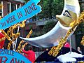
A parade float in the 2007 Strawberry Festival
See also
 In Spanish: Marysville (Washington) para niños
