Mayan cities facts for kids
Maya cities were busy places where many people lived in the ancient Maya civilization of Mesoamerica. These cities were like the hearts of their kingdoms. They were used for many important things:
- Running the government
- Trading goods
- Making things
- Practicing their religion
Unlike some other ancient cities, Maya cities were often spread out. This was because they were built in a tropical jungle environment. People could grow food even within the city limits! Maya cities didn't have neat, straight streets like Teotihuacán in central Mexico.
The Maya kings ruled their lands from grand palaces right in the center of their cities. Cities were often built in places that controlled important trade routes or had valuable resources. This helped the powerful leaders become even richer and more important. These wealthy cities could build amazing temples for public events, which drew even more people to live there. Cities with good food sources and access to trade often grew into the most powerful capitals of the early Maya states.
The way Maya cities interacted with each other was a bit like how city-states in ancient Greece or Renaissance Italy worked. Some cities were connected by long, straight limestone roads called sacbeob. We're not entirely sure if these roads were mainly for trade, politics, or religious journeys.
Contents
How Maya Cities Were Built
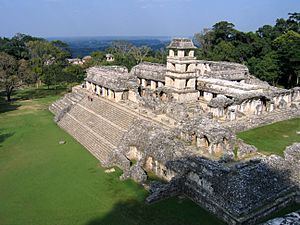
Maya cities didn't follow a strict plan when they were built. Instead, they grew bit by bit, with new palaces, temples, and other buildings added over time. Most Maya cities grew outwards from their center. They also grew upwards, as new buildings were often built on top of older ones.
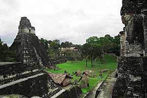
Every Maya city usually had a special area for ceremonies and government. This center was surrounded by a huge, spread-out area where people lived. The city centers always had sacred places, sometimes separated from homes by walls. These sacred areas included:
- Huge pyramid temples
- Other large buildings for important people and events
- Platforms that supported government buildings or fancy homes
Stone monuments were often put up to tell the stories of the ruling families. City centers also had open plazas, sacred ballcourts, and buildings used as marketplaces and schools. Sometimes, special roads called causeways connected the city center to areas further out.
Smaller groups of buildings in the outer parts of the city served as sacred places for important families who weren't royalty. The homes of wealthy families were usually close to these sacred areas. The art found in these rich homes shows how important and respected the families were. The biggest and wealthiest homes sometimes had art and sculptures just as beautiful as those found in royal palaces.
The ceremonial heart of a Maya city was where the rulers lived. It was also where government tasks were done and religious ceremonies took place. People gathered here for public events. The best land around the city center was taken by the homes of the elite. Ordinary people lived further away. Homes were often built on stone platforms to keep them safe from floodwaters during the rainy season.
How Many People Lived There?
For a long time, experts thought that Maya ruins weren't real cities. They believed they were just empty ceremonial places where priests performed rituals for farmers who lived scattered in the jungle. But since the 1960s, archaeologists have mapped these sites. They found that these ceremonial centers were actually the hearts of spread-out cities. Some of these cities had populations that reached tens of thousands of people!
| City Name | Location | Peak Population | Time Period |
|---|---|---|---|
| Coba | Quintana Roo, Mexico | 50,000 | Late Classic |
| Copán | Copán Department, Honduras | 15,000-21,000 | Late Classic |
| Calakmul | Campeche, Mexico | 50,000 | Late Classic |
| Caracol | Cayo District, Belize | 140,000 | Classic |
| Cival | Petén Department, Guatemala | 2,000-5,000 | Late Preclassic |
| El Pilar | Cayo District, Belize; Petén Department, Guatemala | 180,000 | Late Classic |
| Mixco Viejo (Jilotepeque Viejo) | Chimaltenango Department, Guatemala | 1,500 | Late Postclassic |
| Motul de San José | Petén Department, Guatemala | 1,200-2,000 | Late Classic |
| Quiriguá | Izabal Department, Guatemala | 1,200–1,600 | Late Classic |
| Qʼumarkaj | Quiché Department, Guatemala | 15,000 | Late Postclassic |
| Río Azul | Petén Department, Guatemala | 3,500 | Early Classic |
| Santa Rita, Corozal | Corozal District, Belize | 7,000 | Late Postclassic |
| Sayil | Yucatán, Mexico | 10,000 | Terminal Classic |
| Seibal | Petén Department, Guatemala | 10,000 | Late Preclassic |
| Tikal | Petén Department, Guatemala | 100,000 | Late Classic |
| Xunantunich | Cayo District, Belize | 10,000 | Terminal Classic |
A Brief History of Maya Cities
Early City Growth: Middle Preclassic Period
During the Middle Preclassic Period (1000-400 BC), small villages started to grow into cities. By 500 BC, these cities had large temples decorated with stucco masks of their gods. Nakbe in Guatemala is one of the earliest well-known cities in the Maya lowlands. Large buildings there date back to about 750 BC. Nakbe already had the big stone buildings, carved monuments, and causeways that would become common in later Maya cities.
Giant Cities Emerge: Late Preclassic Period
In the Late Preclassic Period (400 BC - 250 AD), the huge city of El Mirador grew to cover about 16 square kilometers (6 square miles). It had paved roads, massive pyramid complexes built around 150 BC, and stone carvings called stelae in its plazas. El Mirador is thought to be one of the first capital cities of the Maya. The swamps in the Mirador Basin seemed to attract the first people to the area, which explains why so many large cities grew up around them.
The city of Tikal was already important by 350 BC, even though it wasn't as big as El Mirador yet. Tikal would later become one of the most important cities of the Classic Period. The great growth of cities during the Late Preclassic period ended in the 1st century AD. Many of the large Maya cities were abandoned, but we don't know why this happened. In the highlands, Kaminaljuyu in Guatemala was already a sprawling city by AD 300.
The Golden Age: Classic Period Cities
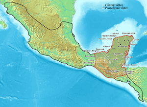
The Classic Period (AD 250-900) was when the Maya civilization reached its peak. In the Early Classic (AD 250-300), cities across the Maya region were influenced by the huge city of Teotihuacan in Mexico. At its height in the Late Classic, Tikal had a population of over 100,000 people. Tikal's main rival was Calakmul, another powerful city. In the southeast, Copán was the most important city. Palenque and Yaxchilán were powerful cities along the Usumacinta River. In the north, Coba was the most important Maya capital.
The size of Maya capital cities could vary a lot. This seemed to depend on how many smaller cities were connected to them. Rulers who controlled more lords could demand more tribute, like cacao (chocolate beans), cloth, and feathers.
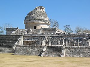
Around the 9th century AD, the central Maya region faced a big political change. Many cities were abandoned, ruling families ended, and people moved north. During this time, called the Terminal Classic, northern cities like Chichen Itza and Uxmal became very active. Major cities in Mexico's Yucatán Peninsula continued to be lived in long after the cities in the southern lowlands were abandoned.
Later Cities: Postclassic Period
The Postclassic Period (AD 900-c.1524) brought many changes to Maya cities. The once-great city of Kaminaljuyu was abandoned after being lived in for almost two thousand years. This was part of a larger change in the highlands and Pacific coast. Cities that were easy to attack were moved to safer, more easily defended hilltop locations. These new cities were often surrounded by deep ravines. Sometimes, ditches and walls were added to make them even safer.
Chichen Itza, in the north, became perhaps the largest, most powerful, and most diverse of all Maya cities. One of the most important cities in the Guatemalan Highlands at this time was Qʼumarkaj, also known as Utatlán. This was the capital of the powerful Kʼicheʼ Maya kingdom.
Conquest and Rediscovery
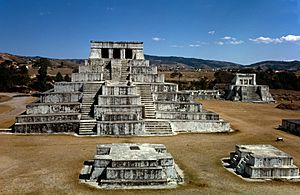
The cities of the Postclassic highland Maya kingdoms were conquered by the Spanish conquistadors in the first half of the 16th century. The Kʼicheʼ capital, Qʼumarkaj, was taken by Pedro de Alvarado in 1524. Soon after, the Spanish were invited as friends into Iximche, the capital city of the Kaqchikel Maya. But this friendship didn't last, and the city was abandoned a few months later. Then, Zaculeu, the Mam Maya capital, fell in 1525. In 1697, Martín de Ursúa attacked the Itza capital Nojpetén. This was the last independent Maya city to fall to the Spanish.
By the 1800s, people knew about five former Maya cities in the Petén region of Guatemala. Hernán Cortés had visited Nojpetén in 1525, and missionaries visited in the early 1600s. The city was finally destroyed when it was conquered in 1697. Juan Galindo, a governor of Petén, described the ruins of the Postclassic city of Topoxte in 1834. Modesto Méndez, another governor, wrote about the ruins of the great city of Tikal in 1848. Teoberto Maler described the ruins of Motul de San José in 1895. San Clemente was described by Karl Sapper in the same year. The number of known cities grew a lot during the 20th century. By 1938, 24 cities in Petén alone had been described.
 | Sharif Bey |
 | Hale Woodruff |
 | Richmond Barthé |
 | Purvis Young |


