
New York–New Jersey Harbor Estuary facts for kids
The New York–New Jersey Harbor Estuary, also known as the Hudson-Raritan Estuary, is a vital waterway system located in the northeastern United States. It sits between the states of New Jersey and New York. This incredible network of rivers, bays, and channels forms one of the most complex natural harbors in the world. It is also one of the busiest ports of the United States, handling a huge amount of ship traffic.
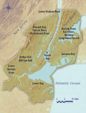


An estuary is a special place where fresh water from rivers mixes with salty ocean water. This creates a unique environment called "brackish" water. The New York–New Jersey Harbor Estuary connects to the New York Bight in the Atlantic Ocean to the southeast and Long Island Sound to the northeast.
While the basic shape of the estuary has stayed the same since explorer Giovanni da Verrazzano visited in 1524, many parts have changed. Some areas, like Ellis Island, look very different today. One of the biggest changes is how deep the shipping channels are. They were naturally about 17 feet (5.2 m) deep but have been made much deeper, to 45 feet (14 m), to allow large modern ships to pass. In some places, this even required blasting through solid rock!
The estuary has a very complex system of tides and currents. Both the Atlantic Ocean and Long Island Sound bring in salty water and tides. However, the Sound is a bit less salty than the open ocean. Rivers also add fresh water that flows into the system. This mix of fresh and salt water, along with the tides, reaches far up the rivers, even as far as Albany. To help understand these complex conditions, the New York Harbor Observing and Prediction System (NYHOPS) uses sensors and weather forecasts to provide real-time information.
Since a big storm in 1962, beaches along the East Coast have been regularly rebuilt. This is done by pumping sand from offshore areas. The United States Army Corps of Engineers (USACE) helps manage these projects. In 2016, the USACE and the Port Authority of New York and New Jersey created a big plan to restore natural areas in the harbor. This plan also aimed to help protect the region from the effects of sea level rise.
Contents
New York–New Jersey Harbor Estuary: A Natural Wonder
This amazing estuary is a hub of activity, both for nature and for people. It's a place where many different kinds of plants and animals thrive. It also serves as a crucial pathway for trade and travel.
What Makes This Estuary Special?
The New York–New Jersey Harbor Estuary is unique because it brings together so many different waterways. It's a dynamic environment where the land meets the sea, creating a rich habitat for wildlife. The constant flow of fresh and saltwater shapes its features.
Exploring the Estuary's Main Waterways
The harbor estuary is made up of many interconnected parts. Let's look at some of the most important ones.

Important Rivers Flowing In
Many rivers bring fresh water into the estuary. These rivers are essential for the ecosystem and for the communities along their banks.
- The Hudson River is one of the most famous. Its lowest part is sometimes called the North River.
- The Passaic River and Raritan River are also major rivers in New Jersey that flow into the estuary.
- The Hackensack River is another important waterway in the region.
- In New York, rivers like the Bronx River and Flushing River contribute to the system.
Key Bays and Inlets
Bays and inlets are large areas of water partly enclosed by land. They are crucial for shipping and provide sheltered habitats.
- New York Bay is divided into the Lower New York Bay and the Upper New York Bay. These are the main parts of the harbor.
- Newark Bay is a busy bay in New Jersey, connected to the Passaic and Hackensack Rivers.
- Raritan Bay is located where the Raritan River meets the Lower New York Bay.
- Jamaica Bay is a large bay in New York, known for its wildlife refuge.
- The Long Island Sound is a large tidal strait that connects to the Atlantic Ocean.
Islands of the Estuary
The estuary is home to many islands, some of which are very famous.
- Manhattan, Staten Island, and Long Island are major islands in New York.
- Ellis Island and Liberty Island are historic islands known for the Statue of Liberty and their role in immigration.
- Governors Island is a historic island in Upper New York Bay, now a public park.
- Rikers Island is a large island in the East River.
- Shooters Island is a smaller island partly in New Jersey and partly in New York.
Important Tidal Passages
Tidal straits are narrow waterways where tides flow strongly. They connect larger bodies of water.
- The Arthur Kill and Kill Van Kull are important straits between New Jersey and Staten Island.
- The Narrows is the strait between Staten Island and Brooklyn, connecting the Upper and Lower New York Bays.
- The East River is a tidal strait that connects Upper New York Bay to Long Island Sound.
- Hell Gate is a particularly narrow and historically challenging part of the East River.
A Busy Hub for Ships and Trade
The New York–New Jersey Harbor Estuary is one of the busiest ports in the world. It plays a huge role in bringing goods to and from the United States.
To allow large cargo ships to safely move through the harbor, special paths called Navigational channels are maintained. The Ambrose Channel is a very important one that leads from the ocean into the harbor. These channels need to be kept deep and clear.
Major Port Facilities
The Port Authority of New York and New Jersey manages most of the large shipping terminals. These facilities are where ships load and unload their cargo.
- In New Jersey, the Port Newark–Elizabeth Marine Terminal is one of the largest container ports in the world.
- In New York, the Red Hook Container Terminal in Brooklyn and the Howland Hook Marine Terminal on Staten Island are also very important.
Keeping the Harbor Safe and Healthy
Many groups work hard to keep the New York–New Jersey Harbor Estuary safe for ships and healthy for nature.
Guiding Ships with Lights
Lighthouses and other lights have guided ships through the harbor for centuries. They help captains navigate safely, especially at night or in bad weather.
- The Sandy Hook Light in New Jersey is one of the oldest working lighthouses in the United States.
- Other important lights include the Robbins Reef Light and the Coney Island Light.
Protecting Our Waterways
Several government agencies work together to protect and manage the estuary.
- The United States Army Corps of Engineers (USACE) helps maintain the shipping channels and works on environmental restoration projects.
- The Port Authority of New York and New Jersey not only runs the ports but also helps develop trade and protect the environment.
- The United States Coast Guard ensures safety on the water, from helping boats in distress to protecting against pollution.
- These groups, along with state and local governments, are always working to keep the estuary clean and healthy for everyone.
Images for kids
-
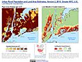
Population density and elevation above sea level in the New York City metropolitan area as of 2010.
.jpg)
See also
- Marine life of New York–New Jersey Harbor Estuary
- Land reclamation in Lower Manhattan
- New York Harbor Storm-Surge Barrier
- Newark Basin
