North Slope Borough, Alaska facts for kids
Quick facts for kids
North Slope Borough
|
||
|---|---|---|
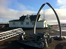
Point Barrow Refuge Station
|
||
|
||
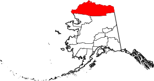
Location within the U.S. state of Alaska
|
||
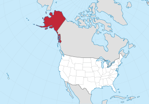 Alaska's location within the U.S. |
||
| Country | ||
| State | ||
| Incorporated | July 2, 1972 | |
| Named for | Alaska North Slope | |
| Seat | Utqiaġvik | |
| Largest city | Utqiaġvik | |
| Area | ||
| • Total | 94,796 sq mi (245,520 km2) | |
| • Land | 88,695 sq mi (229,720 km2) | |
| • Water | 6,101 sq mi (15,800 km2) 6.4% | |
| Population
(2020)
|
||
| • Total | 11,031 | |
| • Estimate
(2022)
|
10,805 |
|
| • Density | 0.116366/sq mi (0.0449290/km2) | |
| Time zone | UTC−9 (Alaska) | |
| • Summer (DST) | UTC−8 (ADT) | |
| Congressional district | At-large | |
The North Slope Borough is the northernmost borough in the US state of Alaska. This means it is the northernmost county-like area in the entire United States. In 2020, about 11,031 people lived here. The main city and government center is Utqiaġvik. It is also the largest city in the borough. Utqiaġvik is the northernmost town in the United States.
Contents
History of the North Slope Borough
The North Slope Borough was created in 1972. Most of the people living there are Inupiat, who are Indigenous to the region. They voted to form the borough after a law called the Alaska Native Claims Settlement Act was passed. The borough was named after the Alaska North Slope basin.
In 1974, the borough adopted its own rules, called a Home Rule Charter. This allowed it to have many governmental powers. The borough handles things like planning, zoning, taxes, and schools.
In 2020, an airline called Ravn Alaska stopped flying. The North Slope Borough tried to take over the airline's planes and equipment. They wanted to make sure flights and supplies could still reach their communities. However, the state's Attorney General said the borough did not have the power to do this.
Geography of the North Slope Borough
The North Slope Borough is very large. It covers about 94,796 square miles. This makes it bigger than 39 of the US states! About 6.4% of its area is water.
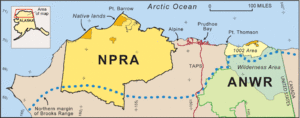
Its western coast is along the Chukchi Sea. Its eastern coast, past Point Barrow, is on the Beaufort Sea.
The North Slope Borough is the largest county-level area in the United States by land size. It has more land than the state of Utah. It is also one of the least crowded county-level places in the US.
Neighboring Areas
The North Slope Borough shares borders with:
- Yukon-Koyukuk Census Area, Alaska – to the southeast
- Northwest Arctic Borough, Alaska – to the southwest
It also shares its eastern border with Yukon, which is a territory in Canada.
Protected Natural Areas
Several parts of the North Slope Borough are protected natural areas. These places help keep nature safe.
- Alaska Maritime National Wildlife Refuge (part of the Chukchi Sea unit)
- Arctic National Wildlife Refuge (part)
- Mollie Beattie Wilderness (part)
- Gates of the Arctic National Park and Preserve (part)
- Noatak National Preserve (part)
- Noatak Wilderness (part)
Other Federal Lands
- National Petroleum Reserve–Alaska
People of the North Slope Borough
| Historical population | |||
|---|---|---|---|
| Census | Pop. | %± | |
| 1960 | 2,133 | — | |
| 1970 | 2,663 | 24.8% | |
| 1980 | 4,199 | 57.7% | |
| 1990 | 5,979 | 42.4% | |
| 2000 | 7,385 | 23.5% | |
| 2010 | 9,430 | 27.7% | |
| 2020 | 11,031 | 17.0% | |
| 2023 (est.) | 10,603 | 12.4% | |
| U.S. Decennial Census 1790-1960 1900-1990 1990-2000 2010-2020 |
|||
In 2020, the North Slope Borough had 11,031 people. Most of the people living there, about 53%, were Native American or Alaska Native. About 33% were White. Other groups included Hispanic or Latino, Native Hawaiian or Pacific Islander, and African American people. About 5% of the population were from two or more races.
Many people in the borough, especially the Iñupiat, speak the Iñupiaq language at home. The average household had about 3 to 4 people.
Economy of the North Slope Borough
Many communities in the North Slope Borough rely on "subsistence resources." This means they get a lot of their food by hunting, fishing, and gathering from the land. For example, in Nuiqsut, a high percentage of families get more than half of their food this way.
Communities in the North Slope Borough
Cities
- Anaktuvuk Pass
- Atqasuk
- Kaktovik
- Nuiqsut
- Point Hope
- Utqiagvik (This is the main city and government center)
- Wainwright
Census-designated places
These are areas defined by the government for counting people.
Unincorporated communities
These are smaller communities that are not officially part of a city or town.
Education in the North Slope Borough
The North Slope Borough has one large school district called the North Slope Borough School District. It is the biggest school district in the United States by area. It covers about 229,731 square kilometers.
See also
 In Spanish: Borough de North Slope para niños
 | Tommie Smith |
 | Simone Manuel |
 | Shani Davis |
 | Simone Biles |
 | Alice Coachman |


