
Pembroke, New Hampshire facts for kids
Quick facts for kids
Pembroke, New Hampshire
|
||
|---|---|---|

Town Hall in 2020
|
||
|
||
| Motto(s):
"Prosper in Pembroke"
|
||

Location in Merrimack County and the state of New Hampshire.
|
||
| Country | United States | |
| State | New Hampshire | |
| County | Merrimack | |
| Incorporated | 1759 | |
| Villages |
|
|
| Area | ||
| • Total | 22.8 sq mi (59.1 km2) | |
| • Land | 22.6 sq mi (58.6 km2) | |
| • Water | 0.2 sq mi (0.5 km2) 0.76% | |
| Elevation | 413 ft (126 m) | |
| Population
(2020)
|
||
| • Total | 7,207 | |
| • Density | 318/sq mi (122.9/km2) | |
| Time zone | UTC−5 (Eastern) | |
| • Summer (DST) | UTC−4 (Eastern) | |
| ZIP Code |
03275
|
|
| Area code(s) | 603 | |
| FIPS code | 33-60020 | |
| GNIS feature ID | 0873696 | |

Pembroke is a town in New Hampshire, located in Merrimack County. In 2020, about 7,207 people lived there. Part of the village of Suncook is also in Pembroke. It's even close to the very center of New Hampshire's population!
Contents
Discovering Pembroke's Past

Pembroke was first given land in 1728. It was called "Lovewell's Town" to honor Captain John Lovewell. He built a strong wooden fence, called a stockade, in Ossipee.
Soon after, the town was called "Suncook." This name came from the Pennacook Abenaki people and referred to the river flowing through the area. In 1759, when the town officially became a town, colonial Governor Benning Wentworth renamed it "Pembroke." This was to honor Henry Herbert, who was the ninth Earl of Pembroke in southern Wales.
Early Industries and Mills
Pembroke's early history shows how important its rivers were. Many mills were built downtown. They used the water power from the Suncook River.
Some of the most famous mills were Pembroke Mills, Webster Manufacturing, and China Manufacturing. They all made a type of fabric called print cloth. Pembroke also had brickmaking businesses. They made bricks from clay found along the Merrimack River. In 1852, a train station was built in Pembroke by the Concord and Portsmouth Railroad.
Exploring Pembroke's Location
According to the United States Census Bureau, Pembroke covers about 59.1 square kilometers (22.8 square miles). Most of this area, 58.6 square kilometers (22.6 square miles), is land. Only about 0.5 square kilometers (0.2 square miles) is water. This means water makes up less than 1% of the town.
Rivers and Hills
The town gets its water from the Merrimack River and its smaller rivers. These smaller rivers are the Suncook and the Soucook. The Merrimack River forms the southwest edge of the town. The Soucook River is on the northwest border. The Suncook River makes up the southeast border.
The highest point in Pembroke is Plausawa Hill. It is about 300 meters (1,000 feet) above sea level. You can find it in the northern part of town.
Neighboring Towns
Pembroke is surrounded by several other towns:
- Loudon (to the north)
- Chichester (to the north)
- Epsom (to the northeast)
- Allenstown (to the southeast)
- Bow (to the southwest)
- Concord (to the northwest)
People of Pembroke: Demographics
| Historical population | |||
|---|---|---|---|
| Census | Pop. | %± | |
| 1790 | 956 | — | |
| 1800 | 982 | 2.7% | |
| 1810 | 1,153 | 17.4% | |
| 1820 | 1,256 | 8.9% | |
| 1830 | 1,312 | 4.5% | |
| 1840 | 1,336 | 1.8% | |
| 1850 | 1,733 | 29.7% | |
| 1860 | 1,313 | −24.2% | |
| 1870 | 2,518 | 91.8% | |
| 1880 | 2,797 | 11.1% | |
| 1890 | 3,172 | 13.4% | |
| 1900 | 3,183 | 0.3% | |
| 1910 | 3,062 | −3.8% | |
| 1920 | 2,563 | −16.3% | |
| 1930 | 2,792 | 8.9% | |
| 1940 | 2,769 | −0.8% | |
| 1950 | 3,094 | 11.7% | |
| 1960 | 3,514 | 13.6% | |
| 1970 | 4,261 | 21.3% | |
| 1980 | 4,861 | 14.1% | |
| 1990 | 6,561 | 35.0% | |
| 2000 | 6,897 | 5.1% | |
| 2010 | 7,115 | 3.2% | |
| 2020 | 7,207 | 1.3% | |
| U.S. Decennial Census | |||
In 2000, there were 6,897 people living in Pembroke. These people lived in 2,661 homes, and 1,876 of these were families. On average, there were about 123 people per square kilometer (302 people per square mile).
Most people in Pembroke were White (97.84%). A small number were African American (0.38%), Native American (0.26%), or Asian (0.38%). About 0.43% of the population was Hispanic or Latino.
Households and Ages
About 37.3% of homes had children under 18 living there. More than half (55.7%) were married couples. About 10.4% of homes had a female head of household with no husband present.
The average home had 2.59 people. The average family had 3.06 people. The population was spread out by age. About 26.9% were under 18. About 33.1% were between 25 and 44 years old. The average age in Pembroke was 37 years.

Getting Around Pembroke: Transportation
Several important roads pass through Pembroke. These include three New Hampshire state routes, one Interstate Highway, and three U.S. routes.
- NH 9 goes through the northern part of town. It connects Concord in the west to Chichester in the east. It joins with US 4 and US 202 near the I-393 freeway. Locals call it Loudon Road.
- NH 28 crosses a small part of northeastern Pembroke. It comes from Allenstown in the south and follows the Suncook River. Then it goes into Epsom in the north. It is known as Pinewood Road.
- NH 106 starts where it meets US 3. This is between Suncook village and the Concord town line. It then heads north and crosses the Soucook River into Concord.
- US 3 enters from Allenstown in the south, crossing the Suncook River. It follows Pembroke Street northwest. Then it crosses the Soucook River into Concord.
- US 4 and US 202 enter the northern part of town from Concord. They are part of the I-393 freeway. They then merge with NH 9 before entering Chichester.
- I-393 ends shortly after entering the northern part of town from Concord. The road continues as NH 9, US 4, and US 202.
Learning in Pembroke: Education
Pembroke has three public schools. The Hill School is for children from kindergarten to fourth grade. Three Rivers School was built in the early 1990s. It is named after the three rivers that form most of the town's borders. This school teaches fifth through eighth grade.
The town's high school is Pembroke Academy. It started in 1818 as a private school. Today, it is a public school. Students from Pembroke attend, as well as students from nearby towns like Allenstown, Epsom, and Chichester. Historically, students from Deerfield also attended. Pembroke Academy has about 1,000 students. Its sports teams are in Class I, which is the second-highest class. The school's mascot is the Spartan.
Pembroke Town Library
The first library in Pembroke was not a public library like we know today. It was a proprietary library. This means people had to pay to be members to borrow books. This library, called the Proprietors of the Pembroke Library, started on December 7, 1798. Members paid yearly fees to buy books. Only members could borrow them.
A Modern Public Library
The Pembroke Town Library, which is a public library supported by taxes, began thanks to new laws in New Hampshire in the 1890s. A law in 1891 said the state would help towns that wanted to start a free public library. The state would give them $100 worth of books and advice on how to run a library.
In 1895, a new law was passed. It was the first of its kind in the country! This law required every town to set aside money for a public library and choose people to manage it. Towns could only avoid this if voters specifically said no each year.
This 1895 law led to the founding of the Pembroke Town Library in 1896. New town libraries often started in any available room. Pembroke's library was no different. After being in several places, planning for a proper library building began in June 1997. The new building officially opened on June 14, 2003.
Library Locations Over Time
Here's where the Pembroke Town Library has been located:
| 1896–1923 | (27 years) | Knox Tailor Shop, Baker's Block, 11 Glass Street |
| 1923–1937 | (14 years) | Another storefront in Baker's Block, 15 Glass Street |
| 1837–1981 | (44 years) | 136 Main Street |
| 1981–2003 | (22 years) | Marston House, 261 Pembroke Street |
| 2003 | New Pembroke Town Library Building |
Famous People from Pembroke
Many notable people have connections to Pembroke:
- Robert E. Cochran (1810–1836): Born in Pembroke, he was a defender at the Alamo. Cochran County, Texas, is named after him.
- Byron M. Cutcheon (1836–1908): An officer in the American Civil War, he received the Medal of Honor. He also served as a U.S. congressman.
- Brian Foster (born 1987): A professional ice hockey goaltender.
- Thomas W. Knox (1835–1896): A journalist and author. He was a correspondent for the New York Herald during the American Civil War.
- Megan McTavish (born 1949): A soap opera writer. She won Daytime Emmy awards for her work on shows like All My Children and General Hospital.
- Caleb Scofield (1978–2018): A bassist and singer for the alternative metal band Cave In.
- Caleb Stark (1759–1838): An officer during the American Revolutionary War. He was the son of General John Stark.
Images for kids
-
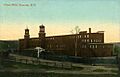
China Mills in 1909

See also
 In Spanish: Pembroke (Nuevo Hampshire) para niños
