Ripley County, Missouri facts for kids
Quick facts for kids
Ripley County
|
|
|---|---|

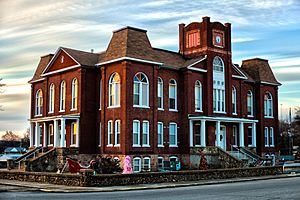
Ripley County Courthouse in Doniphan
|
|

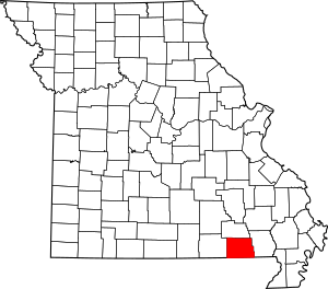
Location within the U.S. state of Missouri
|
|
 Missouri's location within the U.S. |
|
| Country | |
| State | |
| Founded | January 5, 1833 |
| Named for | Eleazer Wheelock Ripley |
| Seat | Doniphan |
| Largest city | Doniphan |
| Area | |
| • Total | 632 sq mi (1,640 km2) |
| • Land | 630 sq mi (1,600 km2) |
| • Water | 2.1 sq mi (5 km2) |
| Population
(2020)
|
|
| • Total | 10,679 |
| • Density | 16.897/sq mi (6.524/km2) |
| Time zone | UTC−6 (Central) |
| • Summer (DST) | UTC−5 (CDT) |
| Congressional district | 8th |
Ripley County is a place in the Ozarks area of Missouri. In 2020, about 10,679 people lived there. The biggest town and main center for the county government is Doniphan.
The county was officially started on January 5, 1833. It is named after Brigadier General Eleazer Wheelock Ripley. He was a brave soldier in the War of 1812.
The original area of Ripley County was much larger. It included parts of what are now Oregon, Howell, Shannon, and Carter counties. The historic Natchitoches Trail runs through Ripley County. This was a Native American path to the Southwest. Pioneers like Stephen F. Austin also used it.
During the American Civil War, many people in Ripley County supported the Southern side. Four colonels from the county fought for the Confederate Army. Some small battles happened in the county during the war. Today, popular places to visit include the Current River and the Mark Twain National Forest.
Contents
History of Ripley County
This area is deep in the rugged, wooded hills of Southern Missouri. Not many people lived here during the 1800s. Ripley County was started in 1833, but it did not become its current size until 1872.
How the County Grew
When the U.S. Congress created the Missouri Territory in 1812, the area that is now Ripley County was part of New Madrid County. Three years later, Lawrence County was formed. This county included all of southern Missouri west of the St. Francis River. It also had a part of northern Arkansas.
In 1818, Wayne County was created. This was a huge county, covering almost one-fifth of the Missouri Territory. Its main town was Greenville.
In 1833, the government created Ripley County from part of Wayne County. At first, Ripley County included today's Ripley, Carter, Shannon, Oregon, and Howell Counties. The county seat was Van Buren.
Over the next 26 years, Ripley County became smaller. New counties were formed from its land. These included Shannon (1841), Oregon (1845), and Carter (1859). The last time the county's borders changed was in 1872.
The County Seat and Courthouses
Most people lived in the southern part of the county. So, voters decided to move the county seat to the new town of Doniphan. A wooden courthouse was built there.
During the Civil War, Union soldiers burned this building. Almost the entire town of Doniphan was destroyed on September 19, 1864. Luckily, William Russell, a county official, had already hidden the county's important record books in a cave south of town. They stayed there until they were found two years after the war.
Because of the war's damage, a new courthouse was not built until 1871. A two-story brick courthouse was then constructed. It cost $10,000, which voters approved. This building was used for county offices until it burned down by accident in January 1898.
Ripley County's current courthouse was designed by William F. Schrage. It was built by John McDonald Anderson between 1898 and 1899. The building originally had a tall central tower. However, a tornado destroyed this tower in 1929.
Workers helped repair and update the courthouse in the 1930s. In the 1970s, it got central heating. This courthouse is now over 100 years old. It is listed on the National Register of Historic Places. It celebrated its 100th birthday in 1999.
Geography of Ripley County
The county covers about 632 square miles. Most of this area, about 630 square miles, is land. Only a small part, about 2.1 square miles, is water.
Neighboring Counties
- Carter County (north)
- Butler County (east)
- Clay County, Arkansas (southeast)
- Randolph County, Arkansas (southwest)
- Oregon County (west)
Main Roads
 U.S. Route 160
 Route 21
 Route 142
Protected Natural Areas
- Mark Twain National Forest (part)
People of Ripley County
| Historical population | |||
|---|---|---|---|
| Census | Pop. | %± | |
| 1840 | 2,856 | — | |
| 1850 | 2,830 | −0.9% | |
| 1860 | 3,747 | 32.4% | |
| 1870 | 3,175 | −15.3% | |
| 1880 | 5,377 | 69.4% | |
| 1890 | 8,512 | 58.3% | |
| 1900 | 13,186 | 54.9% | |
| 1910 | 13,099 | −0.7% | |
| 1920 | 12,061 | −7.9% | |
| 1930 | 11,176 | −7.3% | |
| 1940 | 12,606 | 12.8% | |
| 1950 | 11,414 | −9.5% | |
| 1960 | 9,096 | −20.3% | |
| 1970 | 9,803 | 7.8% | |
| 1980 | 12,458 | 27.1% | |
| 1990 | 12,303 | −1.2% | |
| 2000 | 13,509 | 9.8% | |
| 2010 | 14,100 | 4.4% | |
| 2020 | 10,679 | −24.3% | |
| U.S. Decennial Census 1790-1960 1900-1990 1990-2000 2010-2015 |
|||
In 2000, there were 13,509 people living in Ripley County. Most people were White (97.17%). About 1.33% were Native American. A small number were Black, Asian, or Pacific Islander. About 1.17% were from two or more races. About 0.98% of the people were Hispanic or Latino.
The average family size was about 2.95 people. About 24.8% of the population was under 18 years old. The median age was 39 years.
In 2008, the unemployment rate in Ripley County was 6.4%.
Religion in Ripley County
Ripley County is part of the "Bible Belt." This means that many people follow evangelical Protestant religions. The most common religions are Southern Baptists, Churches of Christ, and Baptist Missionary Association of America.
2020 Census Information
| Race | Number of People | Percentage |
|---|---|---|
| White (Not Hispanic) | 9,885 | 92.6% |
| Black or African American (Not Hispanic) | 31 | 0.3% |
| Native American (Not Hispanic) | 44 | 0.41% |
| Asian (Not Hispanic) | 28 | 0.26% |
| Pacific Islander (Not Hispanic) | 1 | 0.01% |
| Other/Mixed (Not Hispanic) | 563 | 5.3% |
| Hispanic or Latino | 127 | 1.2% |
Education in Ripley County
About 62.1% of adults aged 25 and older in Ripley County have a high school diploma or higher. About 7.8% have a bachelor's degree or higher.
Public Schools
- Current River Area Vocational School – Doniphan – (Grades 9-12)
- Doniphan R-I School District – Doniphan
- Doniphan Elementary School (Kindergarten-Grade 2)
- Doniphan Intermediate School (Grades 3-5)
- Doniphan Middle School (Grades 6-8)
- Doniphan High School (Grades 9-12)
- Naylor R-II School District – Naylor
- Naylor Elementary School (Kindergarten-Grade 6)
- Naylor High School (Grades 7-12)
- Ripley County (Gatewood) R-III School District – Gatewood – (Kindergarten-Grade 8)
- Ripley County (Lone Star) R-IV School District – Doniphan
Private Schools
- West Point Christian Academy – Doniphan – (Kindergarten-Grade 11) – This school is connected to the Assemblies of God church.
Public Libraries
- Doniphan-Ripley County Library
Communities in Ripley County
Cities
Census-Designated Places
Other Small Towns and Places
See also
 In Spanish: Condado de Ripley (Misuri) para niños
 | Jackie Robinson |
 | Jack Johnson |
 | Althea Gibson |
 | Arthur Ashe |
 | Muhammad Ali |

