Saline River (Kansas) facts for kids
Quick facts for kids Saline River |
|
|---|---|

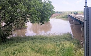
Saline River near Russell, Kansas
|
|

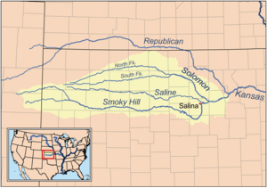
Map of the Smoky Hill drainage basin including the Saline River
|
|
| Other name(s) | Ne Miskua |
| Country | United States |
| State | Kansas |
| Physical characteristics | |
| River mouth | Smoky Hill River New Cambria, Kansas 1,171 ft (357 m) 38°51′28″N 97°30′22″W / 38.85778°N 97.50611°W |
| Length | 397 mi (639 km) |
| Basin features | |
| Basin size | 3,419 sq mi (8,860 km2) |
| Tributaries |
|
| Watersheds | Saline-Smoky Hill-Kansas-Missouri-Mississippi |
The Saline River is a long river in the central Great Plains of North America. It flows for about 397 miles (639 km). This river is a tributary of the Smoky Hill River. The entire Saline River is located within the state of Kansas in the United States. Its name comes from a French translation of its Native American name, Ne Miskua. This name means "salty water," which describes the river's taste.
Contents
Where the Saline River Flows
The Saline River begins in the High Plains of northwestern Kansas. It actually starts as two smaller rivers. The south part of the river begins near the border of Sherman County and Thomas County. The north part starts in the middle of Thomas County.
River's Journey Through Kansas
These two smaller rivers meet in Sheridan County. This meeting point is about 5 miles (8 km) northwest of Grinnell, Kansas. From there, the Saline River flows east for 397 miles (639 km). It travels through the Smoky Hills region in north-central Kansas. The river finally joins the Smoky Hill River about 1 mile south of New Cambria, Kansas in Saline County.
The Saline River flows slowly and is not used for boats or shipping. Its bottom is made of sand and mud. It does not have any other large rivers flowing into it.
Counties the River Crosses
The Saline River flows through several counties in Kansas:
- Thomas County, Kansas
- Sheridan County, Kansas
- Graham County, Kansas
- Trego County, Kansas
- Ellis County, Kansas
- Russell County, Kansas
- Lincoln County, Kansas
- Ottawa County, Kansas
- Saline County, Kansas
History of the Saline River
The first time the Saline River was written about was on October 18, 1724. A French explorer named Etienne Venyard de Bourgmont explored the area. He wrote that he found a "small river where the water was briny" (salty). Bourgmont was traveling to meet with the Padouca people. Their main village was located along the Saline River.
Early American Explorers and Native Peoples
In 1806, an American group led by Zebulon Pike crossed the river. They were on their way to visit the Pawnee. By 1817, the river was known as the "Grand Saline."
The Pawnee and the Kansa tribes used the land along the Saline River for hunting. They lived there until the 1850s, when American settlers started moving in. The Kansas–Nebraska Act of 1854 created the Kansas Territory. This territory included all of the Saline River area. By 1873, the U.S. government moved the Kansa people to a special area called a reservation. This reservation was in what is now Oklahoma.
Battles and Floods
In August 1867, Cheyenne warriors attacked a group of railroad workers in Ellis County. This event led to a fight between the Cheyenne and Buffalo Soldiers from Fort Hays. This fight is known as "The Battle of the Saline River."
The Saline River sometimes had floods in the late 1800s. Very bad floods happened in 1858, 1867, and 1903. To help control these floods, the U.S. Army Corps of Engineers built a dam on the river in 1964. This dam is in eastern Russell County and created Wilson Lake (Kansas).
Related Topics
See also
 In Spanish: Río Saline (Kansas) para niños

