Sumner County, Tennessee facts for kids
Quick facts for kids
Sumner County
|
|||
|---|---|---|---|

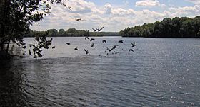
Old Hickory Lake at Bledsoe Creek State Park
|
|||
|
|||

Location within the U.S. state of Tennessee
|
|||
 Tennessee's location within the U.S. |
|||
| Country | |||
| State | |||
| Founded | November 1786 | ||
| Named for | Jethro Sumner | ||
| Seat | Gallatin | ||
| Largest city | Hendersonville | ||
| Area | |||
| • Total | 543 sq mi (1,410 km2) | ||
| • Land | 529 sq mi (1,370 km2) | ||
| • Water | 14 sq mi (40 km2) 2.5% | ||
| Population
(2020)
|
|||
| • Total | 196,281 | ||
| • Estimate
(2023)
|
207,994 |
||
| • Density | 361.5/sq mi (139.57/km2) | ||
| Congressional district | 6th | ||
Sumner County is a county located in the middle of northern Tennessee, United States. In 2020, about 196,281 people lived there.
The main city and county seat is Gallatin. The biggest city is Hendersonville. The county is named after General Jethro Sumner, a hero from the American Revolutionary War.
Sumner County is part of the larger Nashville-Davidson area. It has eight cities, including Gallatin, Hendersonville, and Portland. The county is about 25 miles (40 km) northeast of Nashville.
Contents
History
Long before Europeans arrived, different groups of Native Americans lived in Sumner County for thousands of years. They had campsites and villages, especially along the Cumberland River. You can still see large earth mounds built by the Mississippian people in places like Hendersonville and Castalian Springs. Native Americans also used the natural springs for their healing powers.
Longhunters, who were explorers and traders, came to the area in the 1760s. They followed trails made by Native Americans and buffalo. By the early 1780s, they built trading posts. One important post was Mansker's Station, built by Kasper Mansker. Another was Bledsoe's Station, built by Isaac Bledsoe.
Sumner County officially started in 1786. This was just three years after the American Revolutionary War ended. At that time, Tennessee was still the western part of North Carolina.
During the 1800s, the county became a farming area. Farmers grew crops like tobacco and hemp. They also raised special kinds of livestock. Many settlers came from Kentucky, where these products were also important. Large farms often used the labor of enslaved African Americans. Some buildings from this time, used to house enslaved people, still exist in Gallatin.
During the American Civil War, Union troops took control of most of Tennessee starting in 1862. A Union commander named Eleazer A. Paine was based in Gallatin. He was known for being very strict and harsh. He was later replaced because of how he treated people.
In 1873, a serious disease called cholera hit the county hard. Cholera is a sickness that spreads through dirty water. About 120 people in Sumner County died from cholera that year, mostly in the summer. Most of the people who died were African Americans. Many families, both Black and white, lost several members.
Geography
Sumner County covers a total area of 543 square miles (1,406 square kilometers). About 529 square miles (1,370 square kilometers) is land, and 14 square miles (36 square kilometers) is water.
The county is in Middle Tennessee, right on the border with Kentucky. The Cumberland River was very important for trade and travel a long time ago. It flows into the Ohio River, which then leads to the Mississippi River and the port of New Orleans. Sumner County is part of the greater Nashville area.
Nearby Counties
- Davidson County (southwest)
- Macon County (east)
- Robertson County (west)
- Trousdale County (southeast)
- Wilson County (south)
- Allen County, Kentucky (northeast)
- Simpson County, Kentucky (northwest)
Protected Areas
- Bledsoe Creek State Park
- Cragfont State Historic Site
- Gallatin Steam Plant Wildlife Management Area
- Old Hickory Lock and Dam Wildlife Management Area (part)
- Rock Castle State Historic Site
- Taylor Hollow State Natural Area
- Wynnewood State Historic Site
Major Roads
 I-65
I-65 US 31W
 US 31E
 US 41
US 41 US 231
 SR 25
SR 25 SR 52
SR 52 SR 76
SR 76 SR 109
 SR 174
 SR 257
 SR 258
 SR 259
 SR 386
People Living in Sumner County
| Historical population | |||
|---|---|---|---|
| Census | Pop. | %± | |
| 1800 | 4,616 | — | |
| 1810 | 13,792 | 198.8% | |
| 1820 | 19,211 | 39.3% | |
| 1830 | 20,569 | 7.1% | |
| 1840 | 22,415 | 9.0% | |
| 1850 | 22,717 | 1.3% | |
| 1860 | 22,030 | −3.0% | |
| 1870 | 23,711 | 7.6% | |
| 1880 | 23,625 | −0.4% | |
| 1890 | 23,668 | 0.2% | |
| 1900 | 26,072 | 10.2% | |
| 1910 | 25,621 | −1.7% | |
| 1920 | 27,708 | 8.1% | |
| 1930 | 28,622 | 3.3% | |
| 1940 | 32,719 | 14.3% | |
| 1950 | 33,533 | 2.5% | |
| 1960 | 36,217 | 8.0% | |
| 1970 | 56,106 | 54.9% | |
| 1980 | 85,790 | 52.9% | |
| 1990 | 103,281 | 20.4% | |
| 2000 | 130,449 | 26.3% | |
| 2010 | 160,645 | 23.1% | |
| 2020 | 196,281 | 22.2% | |
| 2023 (est.) | 207,994 | 29.5% | |
| U.S. Decennial Census 1790-1960 1900–1990 1990-2000 2010–2020 |
|||
2020 Census Information
| Group | Number | Percentage |
|---|---|---|
| White (not Hispanic) | 155,169 | 79.05% |
| Black or African American (not Hispanic) | 15,537 | 7.92% |
| Native American | 476 | 0.24% |
| Asian | 2,932 | 1.49% |
| Pacific Islander | 116 | 0.06% |
| Other/Mixed | 9,181 | 4.68% |
| Hispanic or Latino | 12,870 | 6.56% |
In 2020, there were 196,281 people living in Sumner County. There were 70,098 households and 51,272 families.
2010 Census Information
In 2010, the county had 160,645 people. There were about 304 people per square mile (117 people per square kilometer).
Most people in the county were White (89.67%). Other groups included African American (6.42%), Asian (1.02%), and Native American (0.29%). About 3.93% of the population was Hispanic or Latino.
About 26% of households had children under 18. Most households (57%) were married couples. The average household had 2.61 people.
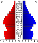
The average age of people in the county was 38.6 years. About 25% of the population was under 18, and 12.6% was 65 or older. Slightly more than half of the population (51.2%) were females.
The average income for a household in the county was $54,916. For families, it was $65,313. About 10.1% of all people lived below the poverty line.
Education
Public Schools
Schools in Sumner County are managed by the Sumner County Board of Education. This group has twelve members. Eleven members are elected from different school areas. The twelfth member is the Director of Schools. The board meets every month, and anyone can attend these meetings.
Private Schools
- Saint John Vianney Catholic Elementary School (Kindergarten to 8th grade)
- Sumner Academy (Kindergarten to 8th grade)
- John Paul II High School
- Aaron Academy (Kindergarten to 12th grade)
- Hendersonville Christian Academy (Pre-Kindergarten to 12th grade)
- Restoring Hope Christian Academy (Pre-Kindergarten to 12th grade)
Colleges
- Volunteer State Community College
- Union University (Hendersonville Campus)
- Welch College
Communities
Cities
- Gallatin (county seat)
- Goodlettsville (partly in Davidson County)
- Hendersonville
- Millersville (partly in Robertson County)
- Mitchellville
- Portland (partly in Robertson County)
- White House (small part in Robertson County)
Town
Census-Designated Places
Unincorporated Communities
Famous People
Horace Lawson Hunley, who invented submarines, was born in Sumner County on June 20, 1823. He and seven other crew members drowned during a test dive in 1863. After his death, his submarine was named the H.L. Hunley in his honor. On February 17, 1864, the Hunley became the first submarine to sink an enemy ship, the USS Housatonic.
James F. Neal, a lawyer who worked on the Watergate case, was born and grew up in Oak Grove. He graduated from Sumner High School in Portland in 1947.
Nacole Rice, a national R&B recording artist, was also born in Sumner County.
See also
 In Spanish: Condado de Sumner (Tennessee) para niños


