
Taylor County, Wisconsin facts for kids
Quick facts for kids
Taylor County
|
|
|---|---|

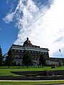
The Taylor County Courthouse in Medford
|
|

Location within the U.S. state of Wisconsin
|
|
 Wisconsin's location within the U.S. |
|
| Country | |
| State | |
| Founded | 1875 |
| Seat | Medford |
| Largest city | Medford |
| Area | |
| • Total | 984 sq mi (2,550 km2) |
| • Land | 975 sq mi (2,530 km2) |
| • Water | 9.5 sq mi (25 km2) 1.0%% |
| Population
(2020)
|
|
| • Total | 19,913 |
| • Estimate
(2023)
|
20,058 |
| • Density | 20.4/sq mi (7.9/km2) |
| Time zone | UTC−6 (Central) |
| • Summer (DST) | UTC−5 (CDT) |
| Congressional district | 7th |
Taylor County is a county located in the state of Wisconsin in the United States. In 2020, about 19,913 people lived here. The main town and county seat is Medford. Taylor County is mostly a countryside area. It has many farms and forests.
Contents
Exploring Taylor County's Past
The first recorded event in Taylor County happened in 1661. At that time, New France claimed Wisconsin. A group of Huron Indians from Ontario had escaped from the Iroquois. They found safety near the Black River, likely around Lake Chelsea.
The Mystery of Father Menard
Father René Menard, a French Jesuit priest, heard the Hurons were starving. He decided to try and reach them. He wanted to baptize them, even though he was not well. In the summer, he and a fur trader set out. They traveled in birchbark canoes down rivers into Wisconsin.
One day, close to the Huron camp, Father Menard left his friend. He went to carry supplies over some rapids. He was never seen again. People believe he disappeared near the Big Rib River, close to Goodrich. This area is in the southeast part of Taylor County.
Early Surveyors and Forests

On June 8, 1847, before any settlers arrived, surveyors entered the county. They worked for the U.S. government. Their job was to mark a north-south line. This line helped measure much of the land in Wisconsin.
For six days, they walked through woods and swamps. The leader of the team wrote about their difficult trip. He said they were always wet and bothered by many mosquitoes. These surveyors noted that the forest had many hemlock, yellow birch, and sugar maple trees. There were also many white pine trees.
The Logging Era
Logging started in the late 1850s. Loggers used rivers to float white pine logs. They sent them down the Big Rib River to the Wisconsin River. They also used the Black River and the Jump and Yellow River into the Chippewa. These log drives continued until about 1900. By then, most of the easy-to-float white pine was gone.
Railroads and New Towns
In 1872 and 1873, the Wisconsin Central Railroad built its line. It went through the forest that would become Medford. The railroad's owners named stations like Medford, Chelsea, and Westboro after towns in Massachusetts. The U.S. Government gave the railroad a lot of land to help pay for the line. This allowed the railroad to carry logs that could not float. Most early settlements grew along this railroad.
In 1875, Taylor County was officially created. It was named after William Robert Taylor, who was Wisconsin's governor at the time. The county seat was set in Medford.

More railroads were built in the early 1900s. These were mainly for logging. They helped move lumber and also carried people and goods. However, once the timber was gone, many of these logging railroads closed down.
Farms and Forests Change
After the valuable timber was cut, lumber companies sold the cleared land to farm families. At first, farmers tried different ways to make a living. They sold milk, eggs, beef, and wool. They also grew crops like cucumbers and peas. Soon, dairy became the main type of farming in the county. By 1923, Medford had one of the largest dairy co-ops in Wisconsin.
Much of the northern part of the county, where trees had been cut, became part of the Chequamegon National Forest in 1933. This land was not good for farming. In the 1930s, the government agreed to manage it as a National Forest.
The Civilian Conservation Corps (CCC) helped replant trees in these areas. The CCC also built the recreation area at Mondeaux. Today, hikers can enjoy the Ice Age National Scenic Trail through the national forest.

The main industries in the past were making lumber and shingles. Medford and Rib Lake had large sawmills. Tanneries in Medford, Perkinstown, and Rib Lake used local hemlock bark for tanning leather. Today, industries have grown to include creameries, window makers, plastics, and food processing. Most of these are in Medford.
Taylor County's Landscape
Taylor County covers about 984 square miles. Most of this is land, with a small amount of water.
How Glaciers Shaped the Land


Taylor County's landscape was mostly shaped by glaciers. Scientists believe that 15,000 to 25,000 years ago, a huge ice sheet called the Laurentide Ice Sheet moved down from Canada. It covered more than two-thirds of Taylor County.
As the ice melted, it left behind choppy hills and small lakes. This area is called the Perkinstown terminal moraine. North and west of this moraine, the land is more gently rolling. Here, you can find large boulders and eskers (long, winding ridges of sand and gravel).
The southeast part of the county was not covered by the last glacier. However, earlier glaciers did cover it. This area is generally flatter because erosion has had more time to smooth it out.
Rivers and Waterways
Taylor County sits on a divide for three river systems. The Jump River and Yellow River flow west into the Chippewa River. The Big Rib River flows southeast to the Wisconsin River. The Black River flows south. All these rivers eventually join the mighty Mississippi River.
Neighboring Counties
- Price County - north
- Lincoln County - east
- Marathon County - southeast
- Clark County - south
- Chippewa County - west
- Rusk County - northwest
Protected Areas
- Chequamegon National Forest (part)
Population Facts
| Historical population | |||
|---|---|---|---|
| Census | Pop. | %± | |
| 1880 | 2,311 | — | |
| 1890 | 6,731 | 191.3% | |
| 1900 | 11,262 | 67.3% | |
| 1910 | 13,641 | 21.1% | |
| 1920 | 18,045 | 32.3% | |
| 1930 | 17,685 | −2.0% | |
| 1940 | 20,105 | 13.7% | |
| 1950 | 18,456 | −8.2% | |
| 1960 | 17,843 | −3.3% | |
| 1970 | 16,958 | −5.0% | |
| 1980 | 18,817 | 11.0% | |
| 1990 | 18,901 | 0.4% | |
| 2000 | 19,680 | 4.1% | |
| 2010 | 20,689 | 5.1% | |
| 2020 | 19,913 | −3.8% | |
| U.S. Decennial Census 1790–1960 1900–1990 1990–2000 2010 2020 |
|||
Who Lives in Taylor County?
In 2020, the population of Taylor County was 19,913 people. Most residents, about 94.8%, were White. Other groups included Black or African American, Asian, and Native American people. About 2.8% of the population was Hispanic or Latino.
The southwest part of the county was settled by many Polish and other Eastern European immigrants. Taylor County's population decreased between 1950 and 1970. However, since 1970, the number of people living here has grown.
Getting Around Taylor County

Wisconsin manages about 120 miles of state highways in Taylor County. These include STH-13, STH-64, STH-73, STH-97, and STH-102. STH-13 goes north-south through the eastern part of the county. STH-73 is the main north-south road in the western part. STH-64 is the main east-west highway.
The Taylor County Highway Department helps maintain these state highways. There are also about 250 miles of county highways. These roads connect the rural areas of Taylor County. Towns are responsible for their own local roads.

Taylor County has a special road called Rustic Road 1. It is near Rib Lake. This 5-mile long gravel road was the first Rustic Road in Wisconsin, named in 1975. It winds through wooded hills and valleys. These were formed by glaciers thousands of years ago.
Main Highways
 Highway 13 (Wisconsin)
 Highway 64 (Wisconsin)
 Highway 73 (Wisconsin)
 Highway 97 (Wisconsin)
 Highway 102 (Wisconsin)
Railroads
- Canadian National
- Watco
Airports
- KMDZ - Taylor County
The main airport in the county is the Taylor County Airport (KMDZ). It is about three miles southeast of Medford. This is the only public airport. It handles about 7,000 flights each year. Most of these are general aviation flights. The airport has two asphalt runways. It also offers fuel, car rental, and flight instruction.
Communities in Taylor County

City
- Medford (county seat)
Villages
Towns
Census-designated places
- Chelsea
- Jump River
- Westboro
- Whittlesey
Unincorporated communities
- Bellinger
- Gad (partial)
- Goodrich
- Hannibal
- Little Black
- Murat
- Perkinstown
- Polley
- Queenstown
Ghost towns

Images for kids
-
The Taylor County Courthouse in Medford
See also
 In Spanish: Condado de Taylor (Wisconsin) para niños
