Texas County, Missouri facts for kids
Quick facts for kids
Texas County
|
|
|---|---|

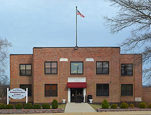
Texas County Administrative Center
|
|

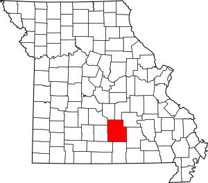
Location within the U.S. state of Missouri
|
|
 Missouri's location within the U.S. |
|
| Country | |
| State | |
| Founded | February 14, 1845 |
| Named for | Republic of Texas |
| Seat | Houston |
| Largest city | Licking |
| Area | |
| • Total | 1,179 sq mi (3,050 km2) |
| • Land | 1,177 sq mi (3,050 km2) |
| • Water | 2.0 sq mi (5 km2) 0.2% |
| Population
(2020)
|
|
| • Total | 24,487 |
| • Density | 20.769/sq mi (8.019/km2) |
| Time zone | UTC−6 (Central) |
| • Summer (DST) | UTC−5 (CDT) |
| Congressional district | 8th |
Texas County is a county in the southern part of Missouri, a state in the United States. In 2020, about 24,487 people lived here. The main town and county seat is Houston.
The county was first set up in 1843. It was called Ashley County back then. In 1845, its name changed to Texas County. This new name honored the Republic of Texas. In 2010, the middle point of the entire U.S. population was found to be in Texas County.
Contents
History of Texas County
Texas County was first created in 1843. It was named after William H. Ashley. He was Missouri's first lieutenant governor. On February 14, 1845, the county was officially organized. At this time, it was renamed to honor the Republic of Texas.
In 1846, a main town was planned for the county. It was built near the center of the county on Brushy Creek. This town was named Houston. It was named after the first president of the Texas Republic. The historic Texas County Courthouse was built in 1932. It was the sixth courthouse for the county. Today, it is used as the county's main office building. It was updated in 1977 and again in 2007. A new justice center was finished in 2008.
Texas County has many rugged hills, springs, creeks, rivers, and caves. Many old Native American mounds have been found here. Their ancient paintings can still be seen on bluffs. This area was part of the land given up by the Osage Nation in 1808.
Pioneers started coming to Texas County in the 1820s. They came from states like Virginia, Kentucky, and Tennessee. They built sawmills along the Big Piney River. These pioneers earned money by floating timber down the Piney River to St. Louis. About 48,000 acres (190 km2) in the northern part of the county are now part of the Mark Twain National Forest. Some land in the southeast is part of the Ozark National Scenic Riverways Park. Small family farms are still a big part of the county's look. In 1850, the first official count showed 2,312 people living in Texas County.
The American Civil War caused a lot of trouble in Texas County. Most people in the area supported the Southern side. The courthouse was used by the Union Army as their headquarters. Houston was an important stop between federal bases in Springfield and Rolla. Some small battles happened here. Confederate soldiers attacked the town and burned many buildings.
Geography and Nature
Texas County is the largest county in Missouri by land area. The U.S. Census Bureau says the county covers about 1,179 square miles (3,050 km2). Most of this, 1,177 square miles (3,049 km2), is land. Only 2.0 square miles (5.2 km2) is water.
Neighboring Counties
- Pulaski County (north)
- Phelps County (north)
- Dent County (northeast)
- Shannon County (east)
- Howell County (south)
- Douglas County (southwest)
- Wright County (west)
- Laclede County (northwest)
Main Roads
Protected Natural Areas
- Mark Twain National Forest (part of it is in the county)
- Ozark National Scenic Riverways (part of it is in the county)
People of Texas County
| Historical population | |||
|---|---|---|---|
| Census | Pop. | %± | |
| 1850 | 2,812 | — | |
| 1860 | 6,067 | 115.8% | |
| 1870 | 9,618 | 58.5% | |
| 1880 | 12,206 | 26.9% | |
| 1890 | 19,406 | 59.0% | |
| 1900 | 22,192 | 14.4% | |
| 1910 | 21,458 | −3.3% | |
| 1920 | 20,548 | −4.2% | |
| 1930 | 18,580 | −9.6% | |
| 1940 | 19,813 | 6.6% | |
| 1950 | 18,992 | −4.1% | |
| 1960 | 17,758 | −6.5% | |
| 1970 | 18,320 | 3.2% | |
| 1980 | 21,070 | 15.0% | |
| 1990 | 21,476 | 1.9% | |
| 2000 | 23,003 | 7.1% | |
| 2010 | 26,008 | 13.1% | |
| 2020 | 24,487 | −5.8% | |
| U.S. Decennial Census 1790-1960 1900-1990 1990-2000 2010-2015 |
|||
In 2000, there were 23,003 people living in Texas County. About 9,378 homes and 6,647 families were counted. The county had about 21 people per square mile. Most people (96.47%) were White. About 0.96% were Native American. About 0.96% of the population was Hispanic or Latino.
About 30.8% of homes had children under 18. Most homes (58.1%) were married couples. The average home had 2.42 people. The average family had 2.89 people.
The median age in the county was 40 years old. About 24.9% of people were under 18. About 17.8% were 65 or older. For every 100 females, there were about 93.5 males.
The median income for a home was $29,260. For a family, it was $34,503. About 21.4% of all people lived below the poverty line. This included 29.1% of those under 18.
Religion in the County
Texas County is part of the "Bible Belt." This means many people follow evangelical Protestant religions. The most common groups are Southern Baptists and Christian Churches & Churches of Christ.
2020 Census Information
| Race | Number | Percent |
|---|---|---|
| White (not Hispanic) | 21,992 | 89.81% |
| Black or African American (not Hispanic) | 780 | 3.2% |
| Native American (not Hispanic) | 142 | 0.58% |
| Asian (not Hispanic) | 65 | 0.26% |
| Pacific Islander (not Hispanic) | 6 | 0.02% |
| Other/Mixed (not Hispanic) | 987 | 4.03% |
| Hispanic or Latino | 515 | 2.1% |
Education in Texas County
Most adults (71.4%) in Texas County have a high school diploma or higher. About 10.8% have a bachelor's degree or more education.
Public Schools
- Cabool R-IV School District – Cabool
- Cabool Elementary School (Grades PK–4)
- Cabool Middle School (Grades 5–8)
- Cabool High School (Grades 9–12)
- Houston R-I School District – Houston
- Houston Elementary School (Grades PK–5)
- Houston Middle School (Grades 6–8)
- Houston High School (Grades 9–12)
- Licking R-VIII School District – Licking
- Licking Elementary School (Grades PK–6)
- Licking High School (Grades 7–12)
- Plato R-V School District – Plato
- Plato Elementary School (Grades PK–5)
- Plato High School (Grades 6–12)
- Raymondville R-VII School District – Raymondville
- Raymondville Elementary School (Grades PK–8)
- Success R-VI School District – Success
- Success Elementary School (Grades K–8)
- Summersville R-II School District – Summersville
- Summersville Elementary School (Grades K–6)
- Summersville High School (Grades 7–12)
Private Schools
- Wellspring Christian School – Houston – (Grades 5–8) – A Christian school.
Special and Vocational Schools
- Exceptional Child Cooperative – Houston – (Grades K–12) – For special education needs.
- Gentry Residential Treatment Facility – Cabool (Grades 6–12) – An alternative school.
Public Libraries
- Texas County Library
Towns and Communities
Famous People from Texas County
- Kenneth Lay - He started and led Enron Corporation.
- Claire McCaskill - A U.S. Senator from Missouri.
- Emmett Kelly - A famous circus performer.
- Orville Tuttle - A professional American Football Player from Licking, Missouri.
See also
 In Spanish: Condado de Texas (Misuri) para niños
 | Toni Morrison |
 | Barack Obama |
 | Martin Luther King Jr. |
 | Ralph Bunche |


