Acworth, New Hampshire facts for kids
Quick facts for kids
Acworth, New Hampshire
|
|
|---|---|
|
Town
|
|

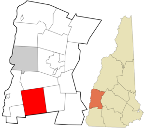
Location in Sullivan County and the state of New Hampshire.
|
|
| Country | United States |
| State | New Hampshire |
| County | Sullivan |
| Incorporated | 1772 |
| Villages |
|
| Area | |
| • Total | 39.1 sq mi (101.2 km2) |
| • Land | 38.8 sq mi (100.5 km2) |
| • Water | 0.3 sq mi (0.7 km2) 0.65% |
| Elevation | 1,489 ft (454 m) |
| Population
(2020)
|
|
| • Total | 853 |
| • Density | 22/sq mi (8.5/km2) |
| Time zone | UTC-5 (Eastern) |
| • Summer (DST) | UTC-4 (Eastern) |
| ZIP codes | |
| Area code(s) | 603 |
| FIPS code | 33-00260 |
| GNIS feature ID | 873525 |
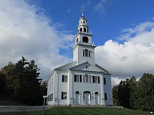
Acworth is a small town in Sullivan County, New Hampshire, United States. It is a quiet place with a rich history. In 2020, about 853 people lived there.
Contents
History of Acworth

Acworth was first planned out by a colonial governor named Benning Wentworth in 1752. It was originally called "Burnet." This name came from William Burnet, who used to be a governor of the Massachusetts Bay Colony.
However, a big war called the French and Indian War started in 1754. Because of the war, no one settled in the area at that time.
Later, in 1766, Governor Wentworth gave the land a new name: Acworth. He named it after Sir Jacob Acworth, who was a leader in the Royal Navy. The first people to permanently settle in Acworth arrived in 1768. They were families from Londonderry, New Hampshire.
Growth and Industry
Acworth officially became a town in 1772, thanks to Governor John Wentworth. But once again, war slowed things down. This time it was the American Revolution.
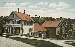
After the Revolution ended, Acworth started to grow very quickly. By 1859, over 1,200 people lived there. Most of them worked in agriculture, which means farming.
The Cold River was very important for the town's businesses. It provided water power for many factories. These included five sawmills (for cutting wood), a gristmill (for grinding grain), a factory that made woolen cloth, and another that made bobbins (parts for weaving). There was also a factory that made pegs and another that made boots and shoes.
Acworth is also known for finding special crystals, like beryl, which are sometimes found in museums. Interestingly, a town in Georgia, called Acworth, Georgia, was named after this town. This happened because a railroad engineer from Acworth, New Hampshire, moved there.
Geography of Acworth
Acworth covers an area of about 101.2 square kilometers (about 39 square miles). Most of this area, about 100.5 square kilometers (38.8 square miles), is land. A small part, about 0.7 square kilometers (0.3 square miles), is water.
The town gets its water from the Cold River and its smaller streams. The entire town is part of the Connecticut River watershed. This means all the water in Acworth eventually flows into the Connecticut River.
The highest point in Acworth is Gove Hill. It is located in the northeastern part of the town. Gove Hill is about 454 meters (1,489 feet) above sea level.
Roads and Nearby Towns
One main state road, New Hampshire Route 123A, goes through Acworth. It follows the Cold River and passes through the village of South Acworth. Other important roads in town include Cold River Road, Hill Road, and a part of Charlestown Road.
Neighboring Towns
Acworth shares its borders with several other towns:
- Unity (to the north)
- Lempster (to the east)
- Marlow (to the southeast)
- Alstead (to the south)
- Langdon (to the southwest)
- Charlestown (to the northwest)
Population of Acworth
| Historical population | |||
|---|---|---|---|
| Census | Pop. | %± | |
| 1790 | 704 | — | |
| 1800 | 1,376 | 95.5% | |
| 1810 | 1,523 | 10.7% | |
| 1820 | 1,479 | −2.9% | |
| 1830 | 1,401 | −5.3% | |
| 1840 | 1,450 | 3.5% | |
| 1850 | 1,251 | −13.7% | |
| 1860 | 1,180 | −5.7% | |
| 1870 | 1,050 | −11.0% | |
| 1880 | 982 | −6.5% | |
| 1890 | 717 | −27.0% | |
| 1900 | 594 | −17.2% | |
| 1910 | 536 | −9.8% | |
| 1920 | 436 | −18.7% | |
| 1930 | 471 | 8.0% | |
| 1940 | 477 | 1.3% | |
| 1950 | 418 | −12.4% | |
| 1960 | 371 | −11.2% | |
| 1970 | 459 | 23.7% | |
| 1980 | 590 | 28.5% | |
| 1990 | 776 | 31.5% | |
| 2000 | 836 | 7.7% | |
| 2010 | 891 | 6.6% | |
| 2020 | 853 | −4.3% | |
| U.S. Decennial Census | |||
The census is a count of how many people live in a place. In 2000, there were 836 people living in Acworth. These people lived in 318 households, and 234 of those were families.
Most people in Acworth (about 96.77%) were White. A small number of people were African American (0.84%), Native American (0.84%), or Asian (0.24%). About 1.32% of the population identified with two or more races. About 1.08% of the people were Hispanic or Latino.
About 30.8% of the households had children under 18 living there. Most households (60.7%) were married couples living together. About 19.8% of households were people living alone.
The average age of people in Acworth in 2000 was 43 years old. About 25.7% of the population was under 18 years old.
Notable People from Acworth
Many interesting people have connections to Acworth, New Hampshire. Here are a few:
- George W. Anderson (1861–1938), a federal judge.
- Nedom L. Angier (1814–1882), who was a mayor of Atlanta and a state treasurer in Georgia.
- John Graham Brooks (1846–1938), a sociologist and political reformer.
- Thomas J. Cram (1804–1883), an engineer who worked for the U.S. Corps of Topographical Engineers.
- Adrian Dubois (born 1987), a professional soccer player.
- Alice B. Fogel, who was the Poet Laureate of New Hampshire from 2014 to 2019.
- Perley Keyes (1774–1834), a member of the New York Senate.
- Talcott Parsons (1902–1979), a famous sociologist from Harvard University.
- Fritz Wetherbee (born 1936), a television personality.
- Hiram Wilson (1803–1864), an abolitionist (someone who worked to end slavery).
- Joseph Gardner Wilson (1826–1873), an Oregon supreme court justice and a U.S. congressman.
- Urban A. Woodbury (1838–1915), a Civil War veteran and the 45th governor of Vermont.
See also
 In Spanish: Acworth (Nuevo Hampshire) para niños


