
Atchison County, Kansas facts for kids
Quick facts for kids
Atchison County
|
|
|---|---|
.png)
Atchison County Courthouse in Atchison (2023)
|
|

Location within the U.S. state of Kansas
|
|
 Kansas's location within the U.S. |
|
| Country | |
| State | |
| Founded | August 25, 1855 |
| Named for | David Rice Atchison |
| Seat | Atchison |
| Largest city | Atchison |
| Area | |
| • Total | 434 sq mi (1,120 km2) |
| • Land | 431 sq mi (1,120 km2) |
| • Water | 2.6 sq mi (7 km2) 0.6%% |
| Population
(2020)
|
|
| • Total | 16,348 |
| • Density | 37.9/sq mi (14.6/km2) |
| Time zone | UTC−6 (Central) |
| • Summer (DST) | UTC−5 (CDT) |
| Area code | 913 |
| Congressional district | 2nd |
Atchison County is a county in the northeast part of Kansas. Its main city and county seat is Atchison. In 2020, about 16,348 people lived here. The county got its name from David Rice Atchison, a U.S. Senator from Missouri. He was involved in a time of conflict called "Bleeding Kansas."
Contents
History of Atchison County
Early Days in Kansas
For thousands of years, Native Americans lived on the Great Plains. They often moved around, following animal herds. In the 16th to 18th centuries, France claimed much of North America.
Later, in 1762, France secretly gave this land to Spain. This happened after the French and Indian War.
Kansas Becomes a State
In 1802, Spain gave most of the land back to France. Then, in 1803, the United States bought a huge area from France. This was part of the Louisiana Purchase. It included most of what is now Kansas.
The Kansas Territory was set up in 1854. Kansas officially became the 34th U.S. state in 1861. Atchison County was created in 1855.
Geography of Atchison County
Atchison County covers about 434 square miles. Most of this is land, with a small amount of water. It is one of the smaller counties in Kansas.
On July 4, 1804, the Lewis and Clark Expedition named Independence Creek. This creek is near the city of Atchison. They named it to celebrate Independence Day.
Neighboring Counties
Atchison County shares borders with several other counties:
- Doniphan County (to the north)
- Buchanan County, Missouri (to the northeast)
- Leavenworth County (to the southeast)
- Platte County, Missouri (to the east)
- Jefferson County (to the south)
- Jackson County (to the west)
- Brown County (to the northwest)
Main Roads in Atchison County
Several important roads run through Atchison County:
- U.S. Route 59
- U.S. Route 73
- U.S. Route 159
- Kansas Highway 7
- Kansas Highway 9
- Kansas Highway 116
People and Population

| Historical population | |||
|---|---|---|---|
| Census | Pop. | %± | |
| 1860 | 7,729 | — | |
| 1870 | 15,507 | 100.6% | |
| 1880 | 26,668 | 72.0% | |
| 1890 | 26,758 | 0.3% | |
| 1900 | 28,606 | 6.9% | |
| 1910 | 28,107 | −1.7% | |
| 1920 | 23,411 | −16.7% | |
| 1930 | 23,945 | 2.3% | |
| 1940 | 22,222 | −7.2% | |
| 1950 | 21,496 | −3.3% | |
| 1960 | 20,898 | −2.8% | |
| 1970 | 19,165 | −8.3% | |
| 1980 | 18,397 | −4.0% | |
| 1990 | 16,932 | −8.0% | |
| 2000 | 16,774 | −0.9% | |
| 2010 | 16,924 | 0.9% | |
| 2020 | 16,348 | −3.4% | |
| 2023 (est.) | 16,016 | −5.4% | |
| U.S. Decennial Census 1790-1960 1900-1990 1990-2000 2010-2020 |
|||
Atchison County is part of the Atchison, KS Micropolitan Statistical Area. This area is also part of the larger Kansas City metropolitan area.
In 2000, there were 16,774 people living in the county. The population density was about 39 people per square mile. Most people were White (91.62%). About 5.32% were Black or African American. Other groups included Native American, Asian, and Hispanic people.
The average age in the county was 36 years old. About 26.70% of the population was under 18.
Education in Atchison County
Local School Districts
The county has two main school districts:
- Atchison County USD 377
- Atchison USD 409
Communities in Atchison County

Atchison County has several cities and smaller communities.
Cities in Atchison County
Unincorporated Communities
These are smaller towns or settlements without their own local government. Some might even be in a neighboring county too.
Ghost Towns
These are places where people used to live, but now they are mostly empty.
Indian Reservations
Townships
Atchison County is divided into eight areas called townships. The city of Atchison is separate from these townships for census purposes.
Images for kids
-
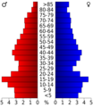
This chart shows the age groups of people in Atchison County in 2000.
-
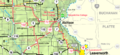
2005 map of Atchison County. The map legend explains the symbols.
See also
 In Spanish: Condado de Atchison (Kansas) para niños
