
Canada–United States border facts for kids
The Canada–United States border, also called the International Boundary, is the longest border in the world between any two countries. This border stretches for about 8,891 kilometers (5,525 miles) across land and water. It includes parts of the Atlantic, Pacific, and Arctic coasts, as well as the Great Lakes. About 2,475 kilometers (1,538 miles) of this border is shared with Alaska. It is the only land border that Canada has.


Contents
How the Canada-US Border Was Created
The border between Canada and the United States has a long history. It was created and changed over many years through different treaties and agreements.
Early Border Agreements (1700s)
The first major agreement about the border came after the American Revolutionary War.
Treaty of Paris (1783)
The Treaty of Paris in 1783 officially ended the war between Great Britain and the United States. This treaty set many of the first border lines. For example, it drew a line from Nova Scotia to the Connecticut River, then down to the 45th parallel of north latitude.

This 45th parallel had already been used since the 1760s as the border between the provinces of Quebec and New York. Surveyors named John Collins and Thomas Valentine mapped this line from 1771 to 1773.
Further west, the St. Lawrence River and the Great Lakes became the border between the United States and what is now Ontario. The border then followed rivers to the Lake of the Woods. From there, it was supposed to go straight west to the Mississippi River. However, this line never actually reaches the Mississippi because the river's source is further south.
Jay Treaty (1794)
The Jay Treaty of 1794 created the International Boundary Commission. This group was in charge of surveying and mapping the border more carefully. It also made sure that British military outposts on the U.S. side were removed. This treaty was later replaced by the Treaty of Ghent in 1815, which ended the War of 1812.
Border Changes in the 1800s
After the War of 1812, more treaties helped to settle border disputes and make the border peaceful.
.jpg)
Rush–Bagot Treaty (1817)
The Rush–Bagot Treaty of 1817 helped to reduce military forces along the border. It also set some early rules for how the border between British North America (Canada) and the United States would be drawn.
London Convention (1818)
The Treaty of 1818 extended the border westward. It drew the line along the 49th parallel from the Northwest Angle at Lake of the Woods all the way to the Rocky Mountains. This treaty also settled land claims for both sides. For example, Britain gave up claims to land south of the 49th parallel, and the U.S. gave up claims to land north of it.
Webster–Ashburton Treaty (1842)
Sometimes, there were disagreements about where the border actually was because of surveying mistakes. The Webster–Ashburton Treaty of 1842 helped fix these problems.

This treaty resolved a conflict called the Aroostook War over the border between Maine, New Brunswick, and the Province of Canada. It also redefined the border in other areas, like between New Hampshire, Vermont, and New York and the Province of Canada.
One interesting story from this time is about "Fort Blunder". The U.S. started building a fort near Rouses Point, New York, on Lake Champlain. But after much of it was built, new measurements showed that the fort was actually in Canada! The treaty solved this problem by leaving the border on the surveyed line, even if it wasn't exactly on the 45th parallel.
Oregon Treaty (1846)
In the 1840s, there was a big argument over the Oregon Country in the west. Some people in the U.S. wanted the border to be much further north, at 54°40′N. Great Britain wanted the border to follow the Columbia River.

The Oregon Treaty of 1846 finally settled this dispute. It set the 49th parallel as the border through the Rocky Mountains.
Boundary Surveys (Mid-1800s)
After these treaties, more surveys were done to mark the border clearly. The Northwest Boundary Survey (1857–1861) mapped the land border. The International Boundary Survey (1872) focused on the border from the Lake of the Woods to the Rocky Mountains. These surveys helped place markers and clear paths to show exactly where the border was.
The Border in the 1900s
The 20th century brought more agreements to manage the border.

In 1903, a dispute over the Alaska border was settled by a special group from the United Kingdom, Canada, and the U.S.
In 1908, a new treaty helped to survey and mark the border through the St. Lawrence River and Great Lakes using modern tools. In 1925, the International Boundary Commission became a permanent group. Its job is to keep the border clear of trees and bushes for about 6 meters (20 feet) wide, 3 meters (10 feet) on each side of the line. This cleared path is called the "border vista".
In 1909, the International Joint Commission was created under the Boundary Waters Treaty. This group helps Canada and the U.S. work together on projects that affect shared waters along the border.
The Border in the 2000s
Recent events have also affected how the border operates.
Border Closures (2020–2021)
After the September 11 attacks in 2001, the border was temporarily closed without warning. This led to new plans to make sure that goods could still cross even if people couldn't. These plans were used again during the COVID-19 pandemic in 2020.

In March 2020, Canada and the U.S. agreed to close the border to "non-essential" travel because of the COVID-19 pandemic. This meant people could not cross for tourism or entertainment. Essential travel, like for work or school, was still allowed. This closure lasted for a long time, until July 2021 for Canadians entering Canada, and November 2021 for Canadians entering the U.S. It was reportedly the first long-term, widespread closure of the border since the War of 1812.
Business groups and politicians from border areas asked for more flexible rules instead of a complete ban on non-essential travel.
See also
 In Spanish: Frontera entre Canadá y Estados Unidos para niños
- United States Customs and Border Protection
- Canada–United States relations
- Mexico–United States border
Images for kids
-
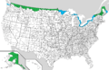
U.S. counties (or county equivalents) sharing a land or water border with Canada Land border Water border only
-
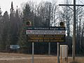
Canadian border crossing sign with lights to alert those crossing to report to customs remotely. Remote customs exists in areas where staffed border crossings are unavailable.
-

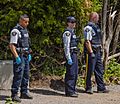
Canada Border Services Agency and U.S. Customs and Border Protection agents reviewing identification. Valid identification is required for crossing the border.
-
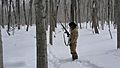
A United States Border Patrol agent tracking someone in harsh winter conditions on the northern border.
-
Members of the Royal Canadian Mounted Police waiting for migrants to cross at Roxham Road in August 2017.
-
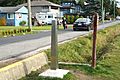
0 Avenue on the Canadian side and the border marker.
-
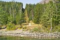
Boundary markers and a 25 foot (7.6 m) swath cut into the forest marking the Alberta-Montana border.
-
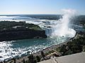
The Horseshoe Falls and the Niagara River mark the Ontario-New York border. Lakes and waterways make up most of Ontario's borders with the United States.
-
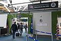
Entrance to a U.S. pre-clearance area at Vancouver International Airport. Pre-clearance areas are situated in several Canadian airports to help speed up the customs process.
-
Ramp facilities at Piney Pinecreek Border Airport. The left-hand building and ramp are north of the border in Canada; those on the right are in the United States.
-
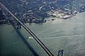
Ambassador Bridge is a suspension bridge that connects Detroit, Michigan, with Windsor, Ontario. This bridge is North America's busiest international crossing for trade.
-
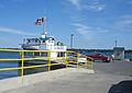
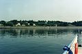
A ferry departing Wolfe Island, Ontario for Cape Vincent, New York.
-
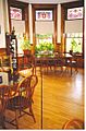
The Haskell Library sits on the international boundary, with the border marked by a black line on the floor of its reading room.
-
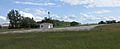
Campobello Island is a Canadian island that can only be reached by land through Maine in the U.S.
-
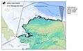
Map of Alaska and the Beaufort Sea. The cross-hatched region marks the disputed water border between Canada and the U.S.


.jpg)


.jpg)
_(9450082470).jpg)
.jpg)


.jpg)

