
Castine, Maine facts for kids
Quick facts for kids
Castine, Maine
|
|
|---|---|

Castine Harbor from Perkins Street
|
|

Castine, Maine
Location in Maine

Castine, Maine
Location in the United States
|
|
| Country | United States |
| State | Maine |
| County | Hancock |
| Founded | 1613 |
| Incorporated | 1796 |
| Villages | Castine North Castine |
| Area | |
| • Total | 20.01 sq mi (51.83 km2) |
| • Land | 7.78 sq mi (20.15 km2) |
| • Water | 12.23 sq mi (31.68 km2) |
| Elevation | 30 ft (9 m) |
| Population
(2020)
|
|
| • Total | 1,320 |
| • Density | 170/sq mi (65.5/km2) |
| Time zone | UTC−5 (Eastern (EST)) |
| • Summer (DST) | UTC−4 (EDT) |
| ZIP Codes |
04420–04421
|
| Area code(s) | 207 |
| FIPS code | 23-11265 |
| GNIS feature ID | 0582396 |
Castine is a small town in Hancock County, located in eastern Maine, United States. In 2020, about 1,320 people lived there. Castine is special because it's home to the Maine Maritime Academy. This school trains future officers and engineers for the United States Merchant Marine and other ocean-related jobs.
The local Abenaki Indians called this area Majabigwaduce. Castine is one of the oldest towns in New England. It was settled even before the Plymouth Colony. It sits on Penobscot Bay, near the historic Fort Pentagouet. Castine has a very exciting history, often called the "battle line of four nations." This means it was fought over by many different countries.
During the 1600s and early 1700s, when France had colonies in North America, Castine was the southern edge of Acadia. New France considered the Kennebec River as Acadia's southern border. The town is named after Jean-Vincent d'Abbadie de Saint-Castin, a French nobleman.
Contents
Castine's Long History

Castine's location was very important in the 1600s. It sits at the mouth of the Penobscot River estuary. This area was rich in furs and timber. It was also a major route into the land. Because of this, European countries were very interested in controlling it.
The area, known as Majabagaduce, changed hands many times. It was controlled by the French, Dutch, and England's Plymouth Colony at different times.
Who Controlled Castine?
Castine was first settled in the winter of 1613. A French leader named Claude de Saint-Étienne de la Tour set up a small trading post here. He traded with the Tarrantine Indians, who are now called the Penobscots.
In 1613, an English captain, Samuel Argall, raided nearby Mount Desert Island. This started a long argument about the border between French Acadia and the English colonies. There's evidence that de La Tour quickly rebuilt his trading post after Argall's raid. Captain John Smith mapped the area in 1614. He also mentioned French traders living there.
In 1625, Charles de la Tour built a fort called Fort Pentagouet. English colonists from the Plymouth Colony took it in 1628. They used it as an outpost for their colony. Governor William Bradford even visited to claim it.

The French took the fort back in 1635. Governor Isaac de Razilly sent Charles de Menou d'Aulnay de Charnisay to get the village back. In 1638, d'Aulnay built a stronger fort called Fort St. Pierre.
In 1653, Acadian Emmanuel Le Borgne attacked the settlement with 100 men. In 1654, Major General Robert Sedgwick led English soldiers and volunteers against Acadia. Before taking its capital, Port Royal, Sedgwick captured and robbed the French settlement at Pentagouêt. The English then controlled Acadia for 16 years.

In 1667, the Treaty of Breda brought peace. French leaders sent Baron Jean-Vincent de Saint-Castin to take charge of Pentagouêt. The baron married an Abenaki woman, the daughter of the chief Modockawando. She was named Mathilde and they had 10 children. He later married another Abenaki woman, Marie Pidiwammiskwa, and had two more children. Castine soon became important for trade and diplomacy.
Castine was the main city for the Acadian region between 1670 and 1674.
During the Franco-Dutch War (1674), Dutch captain Jurriaen Aernoutsz captured Pentagouët and other Acadian ports. He came from New Amsterdam and renamed Acadia to New Holland. The Dutch destroyed most of the fort after a second attack. Saint-Castin took it back in 1676 and renamed the town Bagaduce.
During King William's War, English Governor Sir Edmund Andros robbed Saint-Castin's settlement in 1688. In response, Saint-Castin led an Abenaki war party to attack the English settlement at Pemaquid in August 1689. In 1692, the English took the village again. Major Benjamin Church destroyed the fort and looted the settlement. After Baron de Saint-Castin and his sons went back to France, fewer people lived in the settlement.

During Queen Anne's War, the French attacked Deerfield in February 1704. In response, English Colonel Benjamin Church raided Saint-Castin's settlement (then called Penobscot). He then raided other Acadian villages. Saint-Castin's daughter was captured in this raid.
Becoming a British Colony
After the French and Indian War, England gained control of North America. This opened up lands along the Maine coast for settlers from Massachusetts. By the late 1760s, farmers and traders started settling in "Major Baggadoose." The fur trade was gone, but the area had lots of fish and timber. The British government was interested in the timber for their navy. Bagaduce was especially good for getting pine trees for masts on British warships.
Castine in the American Revolution

In July 1779, during the American Revolution, a British force arrived in Castine's harbor. They landed troops and started building Fort George. This alarmed the Massachusetts government. They sent a large military group known as the Penobscot Expedition. This group included 19 armed ships and 24 transport ships. They carried 344 guns and about 1,200 soldiers. Colonel Paul Revere was in charge of the weapons.

The British soldiers, though outnumbered, fought off American attacks for almost three weeks. In mid-August, more British soldiers arrived. The Americans gave up and retreated up the Penobscot River. They destroyed their own ships to keep them from falling into British hands. This failed Penobscot Expedition cost the Americans a lot of money and 43 ships. It was the biggest American naval defeat until Pearl Harbor in 1941. The British held Castine until the war ended.
After the Revolutionary War, many Americans who supported Britain (called Loyalists) moved to Canadian Maritimes. Some even moved their houses by boat. They crossed the new border at the St. Croix River and started St. Andrews, one of the oldest towns in New Brunswick. Many British soldiers also settled there instead of returning to Britain.
Castine Becomes a Town
In 1762, the Massachusetts government gave the land called Township Number Three to a group of owners. After some disagreements, the land was officially recognized. In 1787, it became the Town of Penobscot. This area included what are now Castine, Penobscot, and Brooksville.
On February 10, 1796, Massachusetts divided Penobscot into two towns: Castine and Penobscot. Castine held its first town meeting on April 4, 1796.
The War of 1812 in Castine

By 1810, Castine had 1,036 people. During the War of 1812, British forces from Halifax, Nova Scotia, attacked Maine in 1814. They wanted to create a new colony called New Ireland. In just 26 days, they took control of Hampden, Bangor, and Machias. They also destroyed or captured 17 American ships.
The British won the Battle of Hampden and occupied Castine for the rest of the war. During this time, a lot of smuggling happened between Castine and the rest of Maine. The Treaty of Ghent ended the war and returned this land to the United States. The British left in April 1815. They took with them about 10,750 pounds from taxes collected in Castine. This money, called the "Castine Fund," was used to help start Dalhousie University in Halifax, Nova Scotia. By 1820, Castine's population was 975.
Castine's Growth and Changes (1820–1960)

After the War of 1812, Castine became a busy and successful place. It was the main town for Hancock County. It was also a center for building ships and trading along the coast. By the 1820s, it was a major stop for American fishing fleets going to the Grand Banks of Newfoundland. Castine also made money from the lumber industry.
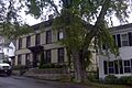
During this time, many beautiful Federal and Greek Revival style mansions were built. You can still see them on the town's streets today.

Castine became less important after the Civil War. Its ships, which once sailed worldwide, now mostly carried coal and wood along the coast. They faced competition from railroads and steamships. Many young people left Castine to find work elsewhere. In 1838, the main county office moved to Ellsworth.
By the 1870s, Castine's charming old buildings and cool summer weather attracted "rusticators." These were wealthy city families looking for a relaxing vacation. Writers like Harriet Beecher Stowe and Henry Wadsworth Longfellow also loved Castine. They wrote about its history, making it seem very romantic. By the 1890s, rich families from places like Boston and Chicago were buying old farms and sea captains' houses. Hotels and inns opened, and Castine became a popular summer spot. Since 1867, it was also home to the Eastern State Normal School.
In the 1930s, the Great Depression and the rise of cars hurt Castine's hotel business. The steamship lines that connected coastal towns also disappeared. The local fishing industry suffered too. The town didn't really recover until the 1960s. That's when new summer visitors rediscovered its charm.
Modern Castine (1980s–2000s)


A big reason for Castine's comeback has been the growth of the Maine Maritime Academy. This school started in 1941 to train sailors. By the 1980s, it offered many courses in engineering, management, and ocean science. Its campus, once the Eastern State Normal School, has a library open to the public and great sports facilities.

Castine has many historic sites and parks. These include the old British earthworks at Fort George. It has a deep harbor for small boats. There's also a club with golf, tennis, and yachting. You can find restaurants and four churches in town. Castine also has a public library, a historical society, and the Wilson Museum. This museum shows exhibits about people, nature, and local history.

Castine's streets are lined with beautiful old houses. These include Federal, Greek Revival, and Cape Cod styles. Large elm trees shade the streets. When old elms get sick, they are replaced with new, disease-resistant ones. The Castine Post Office is in one of the oldest post office buildings in the United States that's still in use. The government started renting the building (built in 1817) in 1833 and later bought it.
Castine's Location
According to the United States Census Bureau, Castine covers about 20.01 square miles (51.83 square kilometers). About 7.78 square miles (20.15 square kilometers) is land, and 12.23 square miles (31.68 square kilometers) is water. The Bagaduce River estuary flows through Castine.

State routes 166 and 166A cross the town. Castine is on a peninsula in Penobscot Bay. It shares a border with Penobscot to the northeast. Brooksville is across the Bagaduce River to the southeast. Islesboro is nearby to the southwest.
Castine's Population
Castine's population was 1,366 people in the 2010 census. There were 380 households and 193 families living in the town. The population density was about 175.6 people per square mile (67.8 people per square kilometer).
Most of the people in Castine were White (96.7%). About 1.2% of the population was Hispanic or Latino. The average age in town was 22.2 years old. Many residents (50.6%) were between 18 and 24 years old, likely students at the Maine Maritime Academy. The town had more males (66.5%) than females (33.5%).
Famous People from Castine

- Philip Booth, poet and teacher
- Noah Brooks, journalist and author
- Deborah Joy Corey, author
- Peter Davis, award-winning film director
- Molly Dewson, activist and feminist
- Germain Doucet, military officer
- David Hall, sound archivist
- Elizabeth Hardwick, writer and critic
- Katharine Butler Hathaway, writer
- Robert Lowell, poet
- Mary McCarthy, novelist
- Don McLean, singer and songwriter
- Benjamin Milliken. American Loyalist
- Richard Rosen, state senator
- Hezekiah Williams, U.S. congressman
Images for kids
-

Castine Harbor from Perkins Street
-
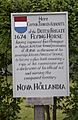
Marker commemorating the Dutch conquest of Acadia (1674)
-

Baron Jean-Vincent de Saint-Castin
-
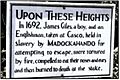
Sign at site of death of John Gyles' brother
-

Ruins of former Fort George in Castine
-
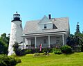
Dice Head Lighthouse in Castine
-
Castine's post office, established in 1794
-
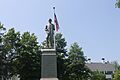
The Civil War monument on the village green
-
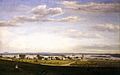
Castine from Fort George, 1856, by Fitz Henry Lane
-

The Witherle Memorial Library
-

Unitarian Universalist Church at 86 Court Street in Castine dates to 1790.
-

Main Street toward the Castine dock on a cloudy day
-
Main Street as viewed from the dock on a sunny summer day
-

Four Flags gift shop in Castine
-
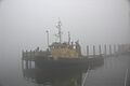
Pentagoet, a tugboat of the Maine Maritime Academy
-

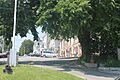
A view in Castine

See also
 In Spanish: Castine (Maine) para niños
