Chetco River facts for kids
Quick facts for kids Chetco River |
|
|---|---|
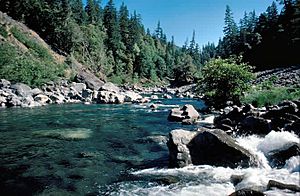
Chetco River near Boulder Creek
|
|
 |
|
| Country | United States |
| State | Oregon |
| County | Curry County |
| Physical characteristics | |
| Main source | Northwest of Chetco Peak Oregon Coast Range, Curry County, Oregon 3,201 ft (976 m) 42°07′47″N 123°52′39″W / 42.12972°N 123.87750°W |
| River mouth | Pacific Ocean Brookings, Curry County, Oregon 0 ft (0 m) 42°02′43″N 124°16′14″W / 42.04528°N 124.27056°W |
| Length | 56 mi (90 km) |
| Basin features | |
| Basin size | 352 sq mi (910 km2) |
| Type: | Wild, Scenic, Recreational |
| Designated: | October 28, 1988 |
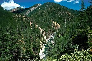
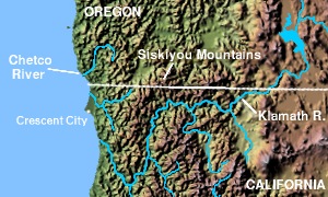
The Chetco River is a 56-mile-long (90 km) river in southwestern Oregon. It flows through Curry County. The river starts high in the mountains and quickly drops to the Pacific Ocean. Most of the river is inside the Rogue River – Siskiyou National Forest. It begins in the Kalmiopsis Wilderness and flows into the ocean near Brookings and Harbor. This is about 6 miles (10 km) north of the California border.
The Chetco River area is mostly untouched. This is thanks to the national forest and wilderness protection. Since 1988, the upper 45 miles (72 km) of the river have been named "Wild and Scenic." This means it's protected for its natural beauty.
Native American people have lived along the Chetco River for thousands of years. Explorers like Sir Francis Drake and Jedediah Smith visited the area long ago. They found the Chetco people living there. Later, settlers came when gold was found in the 1840s and 1850s. Today, over 14,000 people in Brookings and Harbor get their drinking water from the Chetco River.
The Chetco River has very clean water. It is home to many salmon and trout. Many other animals also live here. Some are found only in the Siskiyou Mountains. The world's northernmost group of Redwood trees grows near the river. These are the tallest trees on Earth! Overall, the river supports over 200 kinds of animals. About 97% of the land around the river is covered in forests.
Contents
Where Does the Chetco River Flow?
The Chetco River starts about 4 miles (6 km) east of Chetco Peak. This is about 3,201 feet (975.7 m) above sea level. It flows north, picking up smaller streams like the Little Chetco River. The river then turns west near Pearsoll Peak, which is 5,098-foot-tall (1,554 m). This peak is the highest point in the river's watershed.
The Chetco River then flows south. It joins with the South Fork Chetco River. A few miles further south, it goes through a Redwood forest. The river flows between Bosley Butte and Mount Emily. Mount Emily is famous because it was hit by one of only four bombs dropped in the U.S. by an enemy plane during World War II. This happened in 1942.
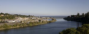
The river then turns southwest. It flows through Alfred A. Loeb State Park. The North Fork Chetco River joins it about 5 miles (8 km) from the mouth. The Chetco River becomes an estuary (where fresh and salt water mix) about 1.7 miles (2.7 km) before it reaches the ocean. It passes by Brookings to the north and Harbor to the south. Finally, it flows into the Pacific Ocean.
How Much Water Does the Chetco River Carry?
The United States Geological Survey measures the river's flow. They have a station about 10.7 miles (17 km) upstream from the mouth. The average flow is 2,263 cubic feet per second (64.08 m3/s). The highest flow ever recorded was 85,400 cubic feet per second (2,420 m3/s) on December 22, 1964. The lowest flow was 42 cubic feet per second (1.2 m3/s) on October 14, 1987.
What is the Chetco River Watershed Like?
The Chetco River watershed is the area of land that drains into the river. It covers 352 square miles (912 km2) of southern Oregon Coast. Most of this land (about 78%) is owned by the United States Forest Service. Another 5% is managed by the Bureau of Land Management. The rest is privately owned or managed by local cities and the state.
About 97% of the land is forest. Two percent is used for farming, and 1% is urban areas. The region is mostly mountains with steep river valleys. The land ranges from sea level up to 5,098 feet (1,554 m) at Pearsoll Peak.
It rains a lot here, between 45 and 140 inches (1,143 and 3,556 mm) each year. Most of the rain falls from October to June. About 70% of the water in the river comes from rain. The rest comes from rain melting snow. Temperatures usually range from 32 and 82 °F (0 and 28 °C). Sometimes, a special weather event called the "Brookings effect" brings very hot winds to the area. This happens because cool air funnels down the river valley and heats up.
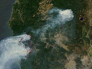
Earthquakes are common in this region. Large ones happen about every 300 years. A huge earthquake in 1700 caused a tsunami that reached Japan! Strong winds are also common. The "Columbus Day Storm" in 1962 brought winds over 190 miles per hour (310 km/h) to a nearby town. Wildfires also happen often. The "Biscuit Fire" in 2002 burned over 500,000 acres (200,000 ha) of the Kalmiopsis Wilderness.
As of 2010, Brookings had about 6,336 people, and Harbor had 2,391. Over 14,000 people in this area rely on the Chetco River for their drinking water.
Plants and Animals of the Chetco River
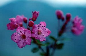
The Chetco River watershed is mostly covered by temperate coniferous forest. This means it has many evergreen trees like Douglas fir, western hemlock, and Port Orford cedar. You can also find Jeffrey pine and golden chinquapin. Other trees like tanoak and bigleaf maple are common. Smaller plants like manzanita and hazelnut grow underneath the trees. The rare Kalmiopsis plant, which the Kalmiopsis Wilderness is named after, only grows in the Siskiyou Mountains.
The most famous trees in the southern part of the watershed are the coastal redwoods. These are some of the tallest trees on Earth! The world's northernmost redwood grove is about 15 miles (24 km) from the river's mouth. These trees are very old, from 300 to 800 years old. Some are over 300 feet (91 m) tall. In the past, many redwoods were cut down. These huge trees create their own special weather by catching moisture from fog and providing a lot of shade.
Over 200 types of animals live in the river and its smaller streams. Birds like loons, ducks, and bald eagles live near the water. Auks and gulls are seen near the river's mouth. The Kalmiopsis area has more different kinds of wildlife than any other place in Oregon.
Mammals like black bears, black-tailed deer, bobcats, and gray foxes are common. The rare Siskiyou chipmunk is found only in the Klamath Mountains. The most common fish that swim from the ocean to the river are steelhead and chinook and coho salmon. Steelhead are found in most streams. Chinook and coho salmon usually stay in the middle part of the river. Coastal cutthroat trout live throughout the watershed. Some go to the ocean, while others stay in the river all year.
How Was the Chetco River Area Formed?
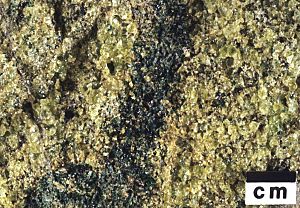
The Chetco River flows through very old rocks, between 400 and 100 million years old. These are the oldest rocks in Oregon. This area was once part of a small continent called the Klamath microcontinent. It was under the ocean near southern California. Over millions of years, it moved north. Pieces of rock, ocean floor, and coral reefs slowly joined together to form small islands.
About 212 to 170 million years ago, volcanoes erupted on this microcontinent. This joined the islands into one large landmass. Later, about 170 to 165 million years ago, the area went through a period of intense plate tectonics. This pushed rocks deep into the Earth, melting them into granite. This granite slowly rose to the surface. A rare rock called peridotite, which comes from deep inside the Earth, is also found here.
The mountains around the Chetco River were formed about 130 million years ago. This happened when the Klamath microcontinent crashed into the much larger North American continent. This collision pushed up the land to create the Klamath Mountains. During the last ice age, glaciers carved out U-shaped valleys and bowls in the mountains. Some alpine lakes still exist from that time.
Today, the main types of rocks in the Chetco region are sandstone, shale, granite, and serpentine. The soil is mostly loam. There is a lot of erosion (when soil and rock are worn away) because of heavy rain, steep slopes, and landslides.
History of the Chetco River Region
People have lived in the Chetco River area for about 1,000 to 3,000 years. The first people were likely ancestors of the Chetco Indians. They built at least nine villages along the river. Two of these were at the river's mouth. The Native Americans called the river "chit taa-ghii~-li~'".
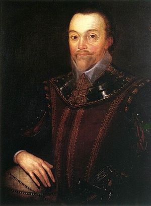
The first Europeans to visit might have been Sir Francis Drake in 1579. He was sailing around the world. The Vancouver Expedition also explored the area in 1792. In 1828, Jedediah Smith and his fur traders camped near a Native American village. Between 1853 and 1855, there were fights between settlers and Native Americans. Many villages were destroyed. In 1856, the remaining Chetco people were moved to the Siletz Reservation.
Oregon became a U.S. state in 1859. Gold and other metals were found in the Chetco area in the 1840s and 1850s. This brought many new settlers. The town of Harbor was founded in 1891. A ferry crossed the river until a bridge opened in 1915.
In 1912, a lumber company moved to the area. They built a sawmill in 1914 and founded the town of Brookings. Brookings became an official town in 1951. The area was hard to reach because of the mountains. But in 1924, Highway 101 was extended to Brookings. In 1932, the Isaac Lee Patterson Bridge was built over the Rogue River to the north. This connected the region to the rest of the Oregon coast.
The Siskiyou National Forest was created in 1906. This protected the upper part of the Chetco watershed. In 2004, it joined with another forest to become the huge Rogue River – Siskiyou National Forest. In 1964, the U.S. Congress created the Kalmiopsis Wilderness. This protected a large area of the eastern Chetco River watershed. It has been expanded several times and is now very large.
On October 28, 1988, a 44.5-mile (71.6 km) part of the Chetco River was named a National Wild and Scenic River. This protects it from its source to the national forest boundary. In 2002, the "Biscuit Fire" burned over 500,000 acres (202,000 ha) of the eastern watershed. It started from lightning strikes and burned for over five months.
In 2007, a gold mining camp opened on the Little Chetco River. This caused concerns about the environment. In 2010, the Chetco River was named one of America's most endangered rivers. This was due to the threat of mining. However, the mining claims were later given up in 2011.
Is the Chetco River Polluted?
The Oregon Department of Environmental Quality (DEQ) checks the Chetco River's water quality. They look at things like temperature, oxygen, and bacteria. Some parts of the Chetco River and its smaller streams have higher temperatures and turbidity (cloudiness) than allowed. High turbidity is usually caused by landslides and erosion.
The DEQ uses a score from 10 (worst) to 100 (ideal) for water quality. The Chetco River usually scores very high, around 90-95. This means its water quality is "excellent." Even with these great scores, the Chetco River is considered the second most polluted stream in Curry County. This shows how clean the other rivers in the county are!
Fun Things to Do on the Chetco River
The Chetco River watershed is a great place for outdoor activities. You can go fishing, four-wheel driving, swimming, boating, camping, and picnicking. Whitewater kayaking is popular in winter when the water is high. There are also many trails for hiking in the Kalmiopsis Wilderness.
There are eight places to launch boats on the river. Alfred A. Loeb State Park is on the river banks. It has cabins and camping sites.
Brookings has several large parks. Azalea Park has five types of wild azaleas. It hosts a music festival in the summer and a light show in December. Chetco Point Park is near the river's mouth. It has picnic tables and great views of the river and ocean. It is also home to the rare Wolf's Evening Primrose flower.
 | Kyle Baker |
 | Joseph Yoakum |
 | Laura Wheeler Waring |
 | Henry Ossawa Tanner |


