
Death Valley facts for kids
Quick facts for kids Death Valley |
|
|---|---|

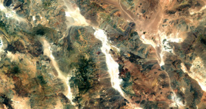
Death Valley as seen from Space Shuttle Columbia in October 1995
|
|

Death Valley
Location in California
|
|
| Floor elevation | −282 ft (−86 m) |
| Area | 3,000 square miles (7,800 km2) |
| Geography | |
| Rivers | Furnace Creek Amargosa River |
Death Valley (called Panamint: Tümpisa by the local Native Americans) is a famous desert valley in Eastern California, United States. It is part of the northern Mojave Desert and borders the Great Basin Desert. This amazing place holds the record for the hottest surface temperature ever recorded on Earth.
Death Valley is also home to Badwater Basin, which is the lowest point in all of North America. It sits about 282 feet (86 m) (86 metres (282 ft)) below sea level! Imagine being below the ocean's surface. This spot is about 84.6 miles (136.2 km) east-southeast of Mount Whitney, which is the highest point in the contiguous United States. Mount Whitney has an elevation of 14,505 feet (4,421 m).
On July 10, 1913, a temperature of 134 °F (57 °C) was recorded at Furnace Creek, California. This is considered the highest ambient air temperature ever recorded on Earth's surface. However, some experts today question if this reading was perfectly accurate.
Most of Death Valley is in Inyo County, California, close to the border with Nevada. It lies east of the Sierra Nevada mountains. Death Valley makes up a large part of Death Valley National Park. It stretches from north to south between the Amargosa Range to the east and the Panamint Range to the west. The Grapevine Mountains and the Owlshead Mountains mark its northern and southern edges. The valley covers an area of about 3,000 sq mi (7,800 km2). The highest point in the National Park is Telescope Peak, which is 11,043 feet (3,366 m) (3,366 metres (11,043 ft)) tall.
The Timbisha tribe of Native Americans has lived in Death Valley for at least a thousand years. Their name for the valley, Tümpisa, means "rock paint." This is because of the red ochre, a type of clay, found there.
The valley got its English name, Death Valley, in the winter of 1849–1850. A group of American pioneers, known as the Death Valley 49ers, got lost while trying to reach the California gold rush. They feared they would all die there. Luckily, most of them made it out, though one person was lost.
Contents
Geology: How Death Valley Was Formed

Death Valley is a special type of valley called a graben. Imagine a block of land that has dropped down between two mountain ranges. That's what a graben is! It sits at the southern end of a long geological ditch called Walker Lane, which goes all the way north to Oregon.
The valley is cut through by a system of strike slip faults, which are cracks in the Earth's crust where land slides past each other. These include the Death Valley Fault and the Furnace Creek Fault. Rivers like Furnace Creek and the Amargosa River flow through parts of the valley. Eventually, their water disappears into the sandy floor.
Death Valley also has large salt pans. These are flat areas covered in salt. Scientists believe that at different times during the Pleistocene era (which ended about 10,000 to 12,000 years ago), a huge inland lake called Lake Manly filled Death Valley. This lake was nearly 100 miles (160 km) long and 600 feet (180 m) deep! It was the last in a chain of lakes that started far north with Mono Lake.
As the climate became a desert, the water in Lake Manly evaporated. This left behind a lot of salts, like common table salt and borax. These salts were later mined in the region, especially between 1883 and 1907.
Climate: Why Death Valley is So Hot and Dry

Death Valley has a subtropical hot desert climate. This means it has very long, extremely hot summers and short, warm winters. It also gets very little rain.
The Rain Shadow Effect
The valley is incredibly dry because it is in the rain shadow of four major mountain ranges. These include the Sierra Nevada and Panamint Range. Imagine moisture-filled air from the Pacific Ocean trying to move inland. As this air rises over each mountain range, it cools down. The moisture then turns into rain or snow on the western slopes of the mountains. By the time the air reaches Death Valley, most of its moisture is gone. This is why there is so little rain.
Reasons for Extreme Heat
Death Valley's extreme heat comes from several factors working together:
- Solar Heating: The ground in the valley (soil, rocks, sand) gets very hot from the sun. The air is clear and dry, and there are not many plants to provide shade. This is especially true in mid-summer when the sun is almost directly overhead.
- Trapping Warm Air: Warm air naturally rises and cools. But in Death Valley, this warm air gets trapped by the tall, steep valley walls. It keeps getting reheated and pushed back down to the valley floor. The valley's north-south direction also traps warm air from the usual west-to-east winds.
- Warm Air from Other Areas: Warm desert regions adjacent to Death Valley, especially to the south and east, often heat the air before it even arrives in Death Valley.
- Warm Mountain Winds: When winds blow up and over mountains, they can get warmer. These dry, warm winds are called foehn winds. Their warmth can come from water vapor turning into clouds. Also, because Death Valley is so far below sea level, the air gets compressed, which heats it up even more.

The intense heat and dryness cause constant drought conditions. This also stops many clouds from forming or passing through the valley. Often, any rain that does fall evaporates before it even reaches the ground. This is called a virga.
The valley's deep, narrow shape plays a big role in its climate. Summer nights offer little relief, with temperatures often staying between 82 to 98 °F (28 to 37 °C). Super-heated air masses constantly blow through the valley, making the air temperature extremely high.
Record Temperatures
The hottest air temperature ever recorded in Death Valley was 134 °F (56.7 °C) on July 10, 1913, at Furnace Creek, California. This is still the highest atmospheric temperature ever recorded on Earth's surface. On June 30, 2013, a verified temperature of 129.2 °F (54.0 °C) (54 °C (129 °F)) was recorded. This ties with Mitribah, Kuwait, for one of the hottest reliably measured air temperatures on Earth. More recently, temperatures of 130 °F (54.4 °C) were recorded in August 2020 and July 2021, but these are still being officially checked. The lowest temperature ever recorded in the valley was 15 °F (−9 °C) (−9.4 °C (15.1 °F)) on January 2, 1913.
The highest ground surface temperature ever recorded in Death Valley was an incredible 201.0 °F (93.9 °C) on July 15, 1972, at Furnace Creek. This is the only recorded surface temperature above 200 °F (93.3 °C).
The summer of 2001 had 154 days in a row where the temperature reached at least 100 °F (38 °C). In July 2024, Death Valley experienced its hottest month ever recorded, with an average daily temperature of 108.5 °F (42.5 °C).

Rainfall and Flooding
Death Valley is very dry. In 1929, 1953, and 1989, no rain was recorded for the entire year. The driest period on record was from 1931 to 1934, when only 0.64 inches (16 mm) of rain fell over 40 months. The average yearly rainfall is about 2.36 inches (60 mm).

Sometimes, Death Valley gets a lot of rain at once. In 2005, it received four times its average annual rainfall of 1.5 inches (38 mm). This caused the lowest part of the valley to fill with a wide, shallow ephemeral lake called Lake Badwater. However, the extreme heat quickly evaporated the lake.

These images show Lake Badwater forming in February 2005 and then evaporating by February 2007. The valley floor returned to its usual look of salt-covered salt flats.
When heavy rains fall on the steep mountains to the west, they can cause flash floods. These floods rush through narrow canyons, carrying everything from fine clay to large rocks. When the water reaches the wider valley, it slows down and spreads out, forming fan-shaped deposits called alluvial fans.
Ecology: Life in the Desert

Even with the extreme heat and little rain, Death Valley is full of life! In spring, after snowmelt, beautiful flowers can carpet the desert floor, sometimes blooming into June. You might spot bighorn sheep, red-tailed hawks, and even wild donkeys.
Death Valley has over 600 springs and ponds. Salt Creek, a shallow, mile-long stream in the middle of the valley, is home to the special Death Valley pupfish. These small fish are a living reminder of the much wetter climate that existed here long ago.
Darwin Falls, on the western edge of the valley, drops 100 feet (30 m) into a large pond. This area is surrounded by willow and cottonwood trees, and more than 80 different kinds of birds have been seen there.
Sometimes, a rare event called salt flowers or Efflorescence happens. This is when rain soaks into the soil and dissolves salt beneath the surface. As the water evaporates, the salt comes to the surface, making the ground look like it has a light dusting of snow.
History: People and Discoveries
Death Valley has been home to the Timbisha tribe of Native Americans for at least the last thousand years. They were also known as the Panamint Shoshone. Their name for the valley, tümpisa, means "rock paint" because of the red clay found there. Some Timbisha families still live in the valley at Furnace Creek today.
The valley got its English name in 1849 during the California Gold Rush. Prospectors and other travelers called it Death Valley because 13 pioneers from an early group of wagon trains died while trying to cross it on their way to the gold fields.
During the 1850s, people mined for gold and silver in the valley. In the 1880s, borax was discovered. It was famously transported out of the valley by mule-drawn wagons.
On February 11, 1933, President Herbert Hoover declared Death Valley a National Monument, which protected the area. In 1994, it became Death Valley National Park and was made much larger to include other nearby valleys.
Notable Attractions and Locations to Explore

Death Valley National Park has many interesting places to visit:
- Badwater Basin
- China Ranch
- Dante's View
- Darwin Falls
- Devils Hole
- Father Crowley Viewpoint
- Furnace Creek
- Harmony Borax Works
- Hells Gate
- Myers Ranch
- Oasis at Death Valley
- Russell Camp
- New Ryan
- Upper and Lower Noonday Camp
- Racetrack Playa, a large dry lakebed within the Valley
- Sailing stones, famous moving stones of Death Valley
- Scotty's Castle
- Shoreline Butte
- Stovepipe Wells
- Tecopa
- Tecopa Hot Springs
- West Side Borax Camp
- Wilson Ranch
- Wildrose Ranger Station
- Zabriskie Point
See also
 In Spanish: Valle de la Muerte para niños
- List of weather records
- Harry Wade Exit Route
