Eagle Ford Group facts for kids
Quick facts for kids Eagle Ford GroupStratigraphic range: Cenomanian-Turonian ~96–90Ma |
|
|---|---|
| Type | Group |
| Sub-units | Britton Formation, Arcadia Park Shale Formation, Lake Waco Formation, South Bosque Formation, Boquillas Formation |
| Underlies | Austin Chalk |
| Overlies | Woodbine Formation or Buda Limestone |
| Lithology | |
| Primary | Shale |
| Other | Marl, limestone, sandstone, volcanic ash beds |
| Location | |
| Region | Texas |
| Country | United States |
| Type section | |
| Named for | Eagle Ford, Texas |
| Named by | Robert T. Hill |
| Year defined | 1887 |
 |
|
The Eagle Ford Group (also known as the Eagle Ford Shale) is a type of rock that formed from sediments. It was laid down during the Cenomanian and Turonian ages of the Late Cretaceous period, about 90 to 96 million years ago. This rock formation covers a large part of what is now Texas. The Eagle Ford is mostly made of shale and marl rich in organic matter and fossils, with some thin layers of limestone.
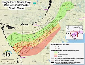
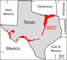
It gets its name from rocks seen near the old community of Eagle Ford, which is now part of Dallas. The Eagle Ford rock layers can be found from the Oklahoma border down to San Antonio, and west to the Rio Grande. It's also deep underground in East Texas and South Texas. This rock is important because it's a "source rock" for oil found in other formations like the Woodbine Formation and Austin Chalk. People have been drilling into the Eagle Ford to get oil and gas, especially in South Texas. In the early 2010s, it was a very active area for drilling, but production slowed down by 2015 due to changes in oil prices.
Contents
What Fossils Are Found in Eagle Ford Rocks?
Fossils are quite common in the Eagle Ford Group. Scientists have found fossils of many different creatures that lived in the ancient sea.
- Sea Animals with Backbones: These include large swimming reptiles like plesiosaurs and mosasaurs. They also found teleost fish and teeth from sharks and other fish.
- Sea Animals Without Backbones: Smaller fossils include crustaceans (like crabs), sea urchins, swimming crinoids (sea lilies), ammonites (ancient shelled creatures), oysters, and other types of snails (called gastropods).
How the Eagle Ford Rocks Formed
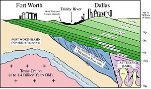
The Eagle Ford Group formed in a large, shallow inland sea that covered much of modern-day Texas during the Late Cretaceous period. This ancient sea was surrounded by land areas like the Ouachita Uplift to the north and the Sabine Uplift to the east.
The water at the bottom of the Eagle Ford sea had very little oxygen for most of the time these rocks were forming. This low-oxygen environment was good for preserving tiny bits of organic matter (like dead plants and animals). Over millions of years, this organic matter turned into the hydrocarbons (oil and gas) found in the Eagle Ford today. Scientists know the water had low oxygen because they find lots of organic matter, very few fossils of creatures that lived on the seafloor, and certain chemicals in the rocks.
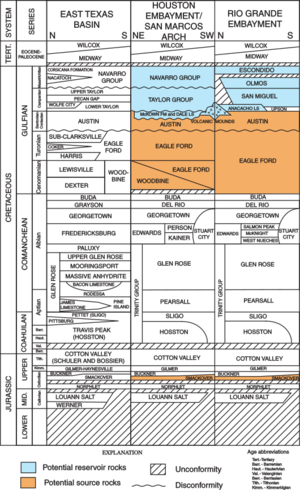
Around 96 million years ago, after a drop in sea level, the sea began to rise again. This allowed the first layers of the Lower Eagle Ford to be deposited. These early layers included organic-rich marls and limestones. As the sea level continued to rise, it covered ancient river deltas in East Texas, starting Eagle Ford rock formation there too.
Later, a river delta started to grow from the Ouachita Uplift into the northern East Texas area. This delta brought sandstone and siltstone into the sea. In other areas, where less sediment was coming in, thin layers of organic-rich marls, limestones, and even volcanic ash were laid down. These layers contain tiny microfossils like coccoliths and foraminifera, as well as fragments of Inoceramus clams and fish bones.
Towards the end of the Late Cenomanian period, the bottom waters of the sea became oxygen-rich again. This event is called the "Benthonic Zone." Evidence for this includes more fossils of seafloor creatures and signs that they stirred up the mud. This change marks the boundary between the Lower and Upper Eagle Ford rocks.
As the sea level began to drop again in the Early Turonian period, the water became shallower. This led to the formation of limestone-rich layers with very little organic matter and many sea urchin fossils. In some areas, like Dallas, new limestone layers formed that show signs of shallow water. Finally, as the sea level continued to fall, more sandstones from deltas were deposited.
What Is the Eagle Ford Unconformity?
After the Woodbine and Eagle Ford formations were laid down, a land area called the Sabine Uplift in East Texas started to rise again about 88 million years ago. This rising caused the eastern parts of the Woodbine and Eagle Ford formations to be lifted out of the water and exposed to the air. Because they were exposed, these rocks started to wear away (erode).
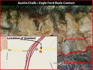
Later, the Austin Chalk formation was deposited on top of these eroded layers. This created a "middle Cretaceous unconformity," which is a gap in the rock record showing where erosion happened. This unconformity is important because it helped trap oil and gas in the East Texas area. Today, the Sabine Uplift is buried deep underground, and the unconformity is also hidden beneath many layers of younger rocks.
Oil and Natural Gas from the Eagle Ford
The Eagle Ford Group is a very important source of oil and natural gas in the United States.
In 2008, a company called Petrohawk drilled the first well to get gas from the Eagle Ford using new methods. This was in La Salle County, Texas. Soon, oil companies found that the productive area stretched about 400 miles from the Texas-Mexico border towards East Texas. The rock layer is about 50 miles wide and 250 feet thick, found at depths between 4,000 and 12,000 feet underground. The Eagle Ford shale has a lot of carbonate, which makes it brittle. This is good because it makes it easier to use hydraulic fracturing (a process to crack the rock) to release the oil and gas.
In 2011, it was estimated that the Eagle Ford Shale had about 3 billion barrels of oil that could be recovered. The U.S. Energy Information Administration also estimated it held over 50 trillion cubic feet of natural gas.
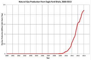
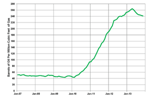
By the end of 2013, oil and gas production from the Eagle Ford had grown very quickly, reaching over 1 million barrels of oil equivalent per day. This huge increase in oil production was one reason why oil prices dropped in late 2014. The oil and gas operations in the Eagle Ford are so large that they can be seen from space at night as a bright patch of lights!
Eagle Ford in Mexico
The Eagle Ford Formation also extends into northern Mexico, where it is known as the Boquillas Formation. In this area, it is about 200 meters (650 feet) thick. Experts believe there are huge amounts of natural gas and oil that could be recovered there. Mexico's national oil company, Pemex, started exploring this area in 2010 and began producing the nation's first shale gas well in 2013.
Challenges for Oil Production
When crude oil prices dropped around the world in 2015, the Eagle Ford area faced tough times. Many drilling rigs were shut down, and oil-field workers in South Texas were especially affected. It became too expensive to drill for oil in some areas when prices were low.
 | Janet Taylor Pickett |
 | Synthia Saint James |
 | Howardena Pindell |
 | Faith Ringgold |


