Eaton County, Michigan facts for kids
Quick facts for kids
Eaton County
|
||
|---|---|---|

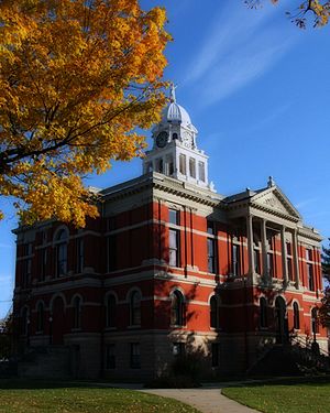
Eaton County Courthouse
|
||
|
||

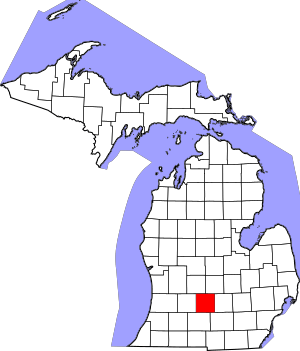
Location within the U.S. state of Michigan
|
||
 Michigan's location within the U.S. |
||
| Country | ||
| State | ||
| Founded | 1837 | |
| Named for | John Eaton | |
| Seat | Charlotte | |
| Largest city | Charlotte | |
| Area | ||
| • Total | 579 sq mi (1,500 km2) | |
| • Land | 575 sq mi (1,490 km2) | |
| • Water | 4.3 sq mi (11 km2) 0.7%% | |
| Population
(2020)
|
||
| • Total | 109,175 | |
| • Estimate
(2023)
|
108,820 |
|
| • Density | 188.56/sq mi (72.80/km2) | |
| Time zone | UTC−5 (Eastern) | |
| • Summer (DST) | UTC−4 (EDT) | |
| Congressional districts | 2nd, 7th | |
Eaton County is a county in the state of Michigan. It's like a special area within the state. In 2020, about 109,175 people lived here. The main city, or county seat, is Charlotte.
Eaton County was officially started in 1837. It was named after John Eaton. He was an important person who worked for U.S. President Andrew Jackson. Because of this, Eaton County is one of Michigan's "Cabinet counties." Eaton County is part of the larger Lansing-East Lansing area in Central Michigan.
Contents
History of Eaton County
Eaton County was created in 1837 from land that wasn't yet part of any county. It got its name from John H. Eaton, who was the Secretary of War for President Andrew Jackson. This is why it's called one of the "Cabinet counties."
The idea for Eaton County began on October 29, 1829. The Michigan government decided where the county's borders would be. They named it after General John H. Eaton. At first, Eaton County was connected to other counties for rules and laws. For example, it was part of St. Joseph County for a short time.
Later, in 1830, it was linked to Kalamazoo County. Then, in 1835, it became a township called "Belleville." The first town meeting was supposed to be held in Eaton County. But at that time, no white settlers lived there!
By 1837, Michigan became a state. On December 29, 1837, Eaton County officially became its own independent county. This meant it had all the same rights as other counties in Michigan.
The first organized township in the county was called "Belleville." However, it was often called "Bellevue" in official papers. Even though the name might have changed, "Bellevue" is what people used.
In 1837, the town of Bellevue was divided. Two new townships were formed: Eaton and Vermontville. Vermontville included the northwest part of the county. Eaton township covered the southeast part. The rest of the county was still part of Bellevue. But in 1838, the northeast part was separated and became the town of Oneida.
In 1832, a surveyor named George W. Barnes bought land in the middle of Eaton County. This land is now part of Charlotte. He asked the governor to choose a county seat. In 1833, a group of people picked Barnes's land as the county seat. They chose a beautiful flat area near Battle Creek.
Geography of Eaton County
Eaton County covers about 579 square miles. Most of this is land (575 square miles). A small part, about 4.3 square miles, is water.
Rivers in Eaton County
Lakes in Eaton County
- Crandell Lake
- Lake Delta
- Lake Interstate
- Pine Lake
Counties Next to Eaton County
- Clinton County – to the northeast
- Ingham County – to the east
- Jackson County – to the southeast
- Calhoun County - to the south
- Barry County – to the west
- Ionia County – to the northwest
Transportation in Eaton County
Main Roads
 I-69
I-69 BL I-69
 BL I-69
 I-96
I-96 BL I-96
 I-496
I-496 M-43
M-43 M-50
M-50 M-66
M-66 M-78
M-78 M-79
M-79 M-99
M-99- M-100
- M-188
Airports in Eaton County
- Fitch H. Beach Airport is in Charlotte. It's used for smaller planes.
- Capital Region International Airport is nearby in Clinton County, Michigan. This airport has flights for travelers.
- Rapids Airway Airport is a small, private airport near Eaton Rapids.
People of Eaton County (Demographics)
| Historical population | |||
|---|---|---|---|
| Census | Pop. | %± | |
| 1840 | 2,379 | — | |
| 1850 | 7,058 | 196.7% | |
| 1860 | 16,476 | 133.4% | |
| 1870 | 25,171 | 52.8% | |
| 1880 | 31,225 | 24.1% | |
| 1890 | 32,094 | 2.8% | |
| 1900 | 31,668 | −1.3% | |
| 1910 | 30,499 | −3.7% | |
| 1920 | 29,377 | −3.7% | |
| 1930 | 31,728 | 8.0% | |
| 1940 | 34,124 | 7.6% | |
| 1950 | 40,023 | 17.3% | |
| 1960 | 49,684 | 24.1% | |
| 1970 | 68,892 | 38.7% | |
| 1980 | 88,337 | 28.2% | |
| 1990 | 92,879 | 5.1% | |
| 2000 | 103,655 | 11.6% | |
| 2010 | 107,759 | 4.0% | |
| 2020 | 109,175 | 1.3% | |
| 2023 (est.) | 108,820 | 1.0% | |
| US Decennial Census 1790-1960 1900-1990 1990-2000 2010-2018 |
|||
In 2010, about 107,759 people lived in Eaton County. Most people (87.8%) were White. About 6.3% were Black or African American. Around 1.7% were Asian. About 4.7% of the people were Hispanic or Latino.
Many people in the county have English (24.2%), German (22.9%), or Irish (9.3%) family backgrounds.
In 2000, the average age of people in the county was 36 years old. About 26.1% of the population was under 18.
Education in Eaton County
Here are some of the school districts in Eaton County:
- Bellevue Community Schools, Bellevue
- Charlotte Public Schools, Charlotte
- Eaton Intermediate School District, Charlotte
- Eaton Rapids Public Schools, Eaton Rapids
- Grand Ledge Public Schools, Grand Ledge
- Maple Valley Schools, Vermontville
- Olivet Community Schools, Olivet
- Oneida Township S/D #3, Oneida Township
- Potterville Public Schools, Potterville
- Roxand Township School District #12, Roxand Township
- Waverly Community Schools, Delta Township
Some students who live in Eaton County go to schools in other counties:
- Students from Dimondale might attend Holt Public Schools in Ingham County.
- Students from Sunfield might attend Lakewood Public Schools in Ionia County.
- A small part of Delta Township is served by Lansing Public Schools in Ingham County.
Communities in Eaton County
Cities
- Charlotte (This is the county seat)
- Eaton Rapids
- Grand Ledge
- Lansing (Only a part of Lansing is in Eaton County)
- Olivet
- Potterville
Villages
Special Place (Census-designated place)
Other Small Communities
- Ainger
- Bismark
- Brookfield
- Canada Settlement
- Carlisle
- Charlesworth
- Chester
- Clinton Junction
- Delta Center
- Delta Mills
- Delwood
- East Walton
- Elmira
- Five Points Corner
- Gresham
- Hoytville
- Kalamo
- Kelly
- Kingsland
- Little Venice
- Millett
- Moore's Station
- Needmore
- Oneida Center
- Packard
- Petrieville
- Shaytown
- Stalls Corner
- Walton
- West Benton
- West Windsor
- Woodbury
Townships
- Bellevue Township
- Benton Township
- Brookfield Township
- Carmel Township
- Chester Township
- Delta Charter Township
- Eaton Rapids Township
- Eaton Township
- Hamlin Township
- Kalamo Township
- Oneida Charter Township
- Roxand Township
- Sunfield Township
- Vermontville Township
- Walton Township
- Windsor Charter Township
See also
 In Spanish: Condado de Eaton para niños
 | DeHart Hubbard |
 | Wilma Rudolph |
 | Jesse Owens |
 | Jackie Joyner-Kersee |
 | Major Taylor |


