
Henry County, Illinois facts for kids
Quick facts for kids
Henry County
|
|
|---|---|
.jpg)
Henry County Courthouse
|
|

Location within the U.S. state of Illinois
|
|
 Illinois's location within the U.S. |
|
| Country | |
| State | |
| Founded | January 13, 1825 |
| Named for | Patrick Henry |
| Seat | Cambridge |
| Largest city | Kewanee |
| Area | |
| • Total | 826 sq mi (2,140 km2) |
| • Land | 823 sq mi (2,130 km2) |
| • Water | 2.7 sq mi (7 km2) 0.3% |
| Population
(2020)
|
|
| • Total | 49,284 |
| • Estimate
(2023)
|
48,448 |
| • Density | 59.67/sq mi (23.037/km2) |
| Time zone | UTC−6 (Central) |
| • Summer (DST) | UTC−5 (CDT) |
| Congressional districts | 16th, 17th |
Henry County is a place in Illinois, a state in the United States. It's like a big district or area within the state. In 2020, about 49,284 people lived here. The main town where the county government is located is called Cambridge. Henry County is also part of a larger area known as the Quad Cities, which includes cities like Davenport, Moline, and Rock Island.
Contents
History of Henry County
Henry County was officially created on January 13, 1825. It was formed from a part of Fulton County, Illinois. The county is named after Patrick Henry, a very important person during the American Revolutionary War. He was known for his strong speeches about freedom and individual rights. He famously said, "Give me liberty, or give me death!"
Early settlers came to Henry County from places like New England and western New York. Many of these people were descendants of English Puritans who had settled in New England a long time ago. These New England settlers helped start five towns in the county: Andover, Wethersfield, Geneseo, Morristown, and La Grange.
The town of Cambridge started in 1843. A person named Rev. Ithamar Pillsbury owned the land there. He decided to set aside some of his property for a town. People bought pieces of land, and building the town began on June 9, 1843. These early settlers from New England made Henry County feel a lot like the culture of early New England.
-
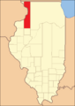
Henry County from the time it was created until 1827
-
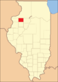
The county between 1827 and 1831
-
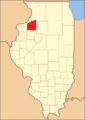
Henry between 1831 and 1836
-
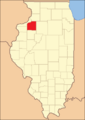
Henry in 1836, after Whiteside County was created


Geography and Climate
Henry County covers a total area of 826 square miles. Most of this area, 823 square miles, is land, and a small part (2.7 square miles) is water. It is the 29th largest county in Illinois. The land in Henry County is mostly flat. The height above sea level ranges from about 650 feet in the northwest to 850 feet in the southeast. A large part of the county, about 86.7% of its land, is used for farming.
Weather in Cambridge
| Weather chart for Cambridge, Illinois | |||||||||||||||||||||||||||||||||||||||||||||||
|---|---|---|---|---|---|---|---|---|---|---|---|---|---|---|---|---|---|---|---|---|---|---|---|---|---|---|---|---|---|---|---|---|---|---|---|---|---|---|---|---|---|---|---|---|---|---|---|
| J | F | M | A | M | J | J | A | S | O | N | D | ||||||||||||||||||||||||||||||||||||
|
1.5
29
13
|
1.6
35
19
|
2.7
47
30
|
3.7
61
40
|
4.2
73
52
|
4.2
82
61
|
3.9
86
66
|
4.3
83
63
|
3.3
76
55
|
3
63
43
|
2.8
47
31
|
2.2
33
19
|
||||||||||||||||||||||||||||||||||||
| temperatures in °F precipitation totals in inches source: The Weather Channel |
|||||||||||||||||||||||||||||||||||||||||||||||
|
Metric conversion
|
|||||||||||||||||||||||||||||||||||||||||||||||
The weather in Henry County changes throughout the year. In Cambridge, the county seat, average temperatures can be as low as 13 degrees Fahrenheit in January. In July, they can reach a high of 86 degrees Fahrenheit. The coldest temperature ever recorded was -24 degrees Fahrenheit in February 1996. The hottest was 103 degrees Fahrenheit in July 1983. The amount of rain and snow also changes. January usually gets about 1.52 inches, while August gets the most, with about 4.32 inches.
Main Roads
 Interstate 74
 Interstate 80
 Interstate 280
 U.S. Highway 6
 U.S. Highway 34
 U.S. Highway 150
 Illinois Route 17
 Illinois Route 78
 Illinois Route 81
 Illinois Route 82
 Illinois Route 84
 Illinois Route 91
 Illinois Route 92
Neighboring Counties
- Rock Island County - northwest
- Whiteside County - northeast
- Bureau County - east
- Stark County - southeast
- Knox County - south
- Mercer County - west
People of Henry County
| Historical population | |||
|---|---|---|---|
| Census | Pop. | %± | |
| 1830 | 41 | — | |
| 1840 | 1,260 | 2,973.2% | |
| 1850 | 3,807 | 202.1% | |
| 1860 | 20,660 | 442.7% | |
| 1870 | 35,506 | 71.9% | |
| 1880 | 36,597 | 3.1% | |
| 1890 | 33,338 | −8.9% | |
| 1900 | 40,049 | 20.1% | |
| 1910 | 41,736 | 4.2% | |
| 1920 | 45,162 | 8.2% | |
| 1930 | 43,851 | −2.9% | |
| 1940 | 43,798 | −0.1% | |
| 1950 | 46,492 | 6.2% | |
| 1960 | 49,317 | 6.1% | |
| 1970 | 53,217 | 7.9% | |
| 1980 | 57,968 | 8.9% | |
| 1990 | 51,159 | −11.7% | |
| 2000 | 51,020 | −0.3% | |
| 2010 | 50,486 | −1.0% | |
| 2020 | 49,284 | −2.4% | |
| 2023 (est.) | 48,448 | −4.0% | |
| US Decennial Census 1790-1960 1900-1990 1990-2000 2010 |
|||

In 2010, there were about 50,486 people living in Henry County. Most people (94.8%) were white. Smaller groups included Black or African American people (1.6%), Asian people (0.4%), and American Indian people (0.2%). About 4.8% of the population was of Hispanic or Latino background.
Many people in Henry County have ancestors from different parts of the world. For example, 30% had German ancestors, 14.6% had Irish ancestors, 12.3% had Swedish ancestors, and 11.5% had English ancestors. About 7.2% identified their ancestry as American.
The average age of people in the county was 41.8 years old. Families living in the county earned a median income of about $61,467 per year.
Towns and Villages
Henry County has many different communities, from larger cities to smaller villages and unincorporated areas.
Cities
Towns
Villages
- Alpha
- Andover
- Bishop Hill
- Cambridge
- Cleveland
- Coal Valley (partially in Henry County)
- Hooppole
- Orion
- Woodhull
Unincorporated Communities
These are smaller areas that are not officially part of a city, town, or village.
- Aliceville
- Briar Bluff
- Brook Lawn
- Dayton
- German Corner
- Green River
- Green Rock
- Hickory Hills
- Level Acres
- Lynn Center
- Morristown
- Nekoma
- Opheim
- Osco
- Shady Beach
- Sunny Hill
- Sunny Hill Estates
- Timber Ridge
- Ulah
- Warner
- Woodcrest
Former Communities
These are places that used to be communities but are no longer active towns or villages.
- Kedron
- Oxford
- Saxon
Townships
Henry County is divided into many smaller areas called townships.
- Alba
- Andover
- Annawan
- Atkinson
- Burns
- Cambridge
- Clover
- Colona
- Cornwall
- Edford
- Galva
- Geneseo
- Hanna
- Kewanee
- Loraine
- Lynn
- Munson
- Osco
- Oxford
- Phenix
- Weller
- Western
- Wethersfield
- Yorktown
See also
 In Spanish: Condado de Henry (Illinois) para niños
