
Jefferson County, West Virginia facts for kids
Quick facts for kids
Jefferson County
|
||
|---|---|---|
_and_West_Virginia_State_Route_51_(Washington_Street)_in_Charles_Town,_Jefferson_County,_West_Virginia.jpg)
|
||
|
||

Location within the U.S. state of West Virginia
|
||
 West Virginia's location within the U.S. |
||
| Country | ||
| State | ||
| Founded | October 26, 1801 | |
| Named for | Thomas Jefferson | |
| Seat | Charles Town | |
| Largest city | Charles Town | |
| Area | ||
| • Total | 212 sq mi (550 km2) | |
| • Land | 210 sq mi (500 km2) | |
| • Water | 2.0 sq mi (5 km2) 1.0%% | |
| Population
(2020)
|
||
| • Total | 57,701 | |
| • Estimate
(2021)
|
58,370 |
|
| • Density | 272.2/sq mi (105.09/km2) | |
| Time zone | UTC−5 (Eastern) | |
| • Summer (DST) | UTC−4 (EDT) | |
| Congressional district | 2nd | |

Jefferson County is a county in West Virginia, located in the beautiful Shenandoah Valley. It's the easternmost county in the state. In 2020, about 57,701 people lived here. The main town and county seat is Charles Town. The county was created in 1801. Today, it's part of the larger Washington metropolitan area.
Contents
History of Jefferson County
How Jefferson County Was Formed
Jefferson County was created from Berkeley County in 1801. People living in the southeastern part of Berkeley County found it too far to travel to their county seat, Martinsburg. Charles Washington, who founded Charles Town and was the brother of George Washington, asked for a new county to be made.
The county was named after Thomas Jefferson. He was the author of the Declaration of Independence and the third President of the United States.
The Story of John Brown's Raid

The county's courthouse was the place where John Brown had his trial. John Brown was an abolitionist, meaning he was against slavery. In October 1859, he led a raid on the federal armory in Harpers Ferry.
About 90 U.S. Marines, led by Army Colonel Robert E. Lee, stopped the raid. John Brown was found guilty of murder and other serious crimes. He was hanged on December 2, 1859, in a field near the Charles Town jail. Many important people watched, including 1,500 cadets from Virginia Military Institute.
Jefferson County During the Civil War
Jefferson County saw a lot of fighting during the American Civil War. Union and Confederate armies often moved through the Shenandoah Valley. Towns like Charles Town and Harpers Ferry changed hands many times.
Jefferson County was special because it was the only part of modern-day West Virginia where the Emancipation Proclamation immediately freed enslaved people. This happened on January 1, 1863.
The Charles Town Courthouse is unique. It held two very important trials for treason. One was John Brown's trial in 1859. The other was about coal companies from the southern part of the state.
Joining West Virginia

Both Berkeley and Jefferson counties had voted to leave the Union in 1861. However, these counties, located along the Potomac River, later voted to join West Virginia in 1863. This vote happened with the permission of the Reorganized Government of Virginia and was overseen by the Union Army.
After the Civil War, Virginia tried to get these counties back. But the counties remained part of West Virginia. In 1871, the U.S. Supreme Court decided that West Virginia, including Berkeley and Jefferson counties, had legally separated from Virginia.
First Rural Free Delivery
In October 1896, Jefferson County made history. It was the first county in the United States to start Rural Free Delivery service. This meant mail was delivered directly to people's homes in the countryside, starting in the towns of Halltown and Uvilla.
Geography of Jefferson County
Jefferson County covers about 212 square miles. Most of this is land, with about 2 square miles of water. It's the only county in West Virginia where you can find the Blue Ridge Mountains and the Shenandoah River, which are famous from the song "Take Me Home, Country Roads" by John Denver. The lowest point in West Virginia is in Jefferson County, where the Potomac River flows into Maryland.
Protected Areas
- Harpers Ferry National Historical Park (part of it)
Rivers and Streams
Neighboring Counties
- Washington County, Maryland (north)
- Loudoun County, Virginia (east)
- Clarke County, Virginia (southwest)
- Berkeley County (northwest)
Main Roads
 U.S. Highway 340
 West Virginia Route 9
 West Virginia Route 45
 West Virginia Route 51
 West Virginia Route 115
 West Virginia Route 230
Population and People
| Historical population | |||
|---|---|---|---|
| Census | Pop. | %± | |
| 1810 | 11,851 | — | |
| 1820 | 13,087 | 10.4% | |
| 1830 | 12,927 | −1.2% | |
| 1840 | 14,082 | 8.9% | |
| 1850 | 15,357 | 9.1% | |
| 1860 | 14,535 | −5.4% | |
| 1870 | 13,219 | −9.1% | |
| 1880 | 15,005 | 13.5% | |
| 1890 | 15,553 | 3.7% | |
| 1900 | 15,935 | 2.5% | |
| 1910 | 15,889 | −0.3% | |
| 1920 | 15,729 | −1.0% | |
| 1930 | 15,780 | 0.3% | |
| 1940 | 16,762 | 6.2% | |
| 1950 | 17,184 | 2.5% | |
| 1960 | 18,665 | 8.6% | |
| 1970 | 21,280 | 14.0% | |
| 1980 | 30,302 | 42.4% | |
| 1990 | 35,926 | 18.6% | |
| 2000 | 42,190 | 17.4% | |
| 2010 | 53,498 | 26.8% | |
| 2020 | 57,701 | 7.9% | |
| 2021 (est.) | 58,370 | 9.1% | |
| U.S. Decennial Census 1790–1960 1900–1990 1990–2000 2010–2020 |
|||
Population in 2020
In 2020, Jefferson County had 57,701 people living in 21,162 households. Most people (81.2%) were White. About 6% were African American, and 1.5% were Asian. People of Hispanic or Latino origin made up 7.2% of the population.
The average age in the county was 41 years old. About 22.1% of the population was under 18. The average household income was $86,711. About 9.7% of the population lived below the poverty line.
Population in 2010
In 2010, there were 53,498 people in the county. The population density was about 255 people per square mile. Most people (87.6%) were white. About 6.6% were black or African American. People of Hispanic or Latino origin made up 4.7% of the population.
The average age was 38.9 years. The average household income was $65,603. About 8.4% of the population lived below the poverty line.
Towns and Communities
Cities in Jefferson County
- Charles Town (This is the county seat)
- Ranson
Towns in Jefferson County
Special Census Areas
These are places that are like towns but not officially incorporated:
Smaller Communities and Villages
- Aldridge
- Bakerton
- Bardane
- Blair
- Bloomery
- Blue Ridge Acres
- Browns Corner
- Clips Mill
- Duffields
- Egypt
- Engle
- Franklintown
- Gibsontown
- Halltown
- Jamestown
- Johnsontown
- Kabletown
- Kearneysville
- Keyes Ferry Acres
- Leetown
- Mannings
- Mechanicstown
- Mechlenberg Heights
- Meyerstown
- Millville
- Moler Crossroads
- Mountain Mission
- Reedson
- Rippon
- Riverside
- Silver Grove
- Skeetersville
- Summit Point
- Uvilla
- Wheatland
- Zoar
Magisterial Districts

Jefferson County is divided into five areas called magisterial districts:
- Charles Town
- Harpers Ferry
- Kabletown
- Middleway
- Shepherdstown
Historic Buildings and Places
Jefferson County has many old and important buildings and places. Many of these are listed on the National Register of Historic Places. Here are a few examples:
- Middleway Historic District (built in 1734)
- White House Farm (built in 1740)
- Hopewell (Millville, West Virginia) (built in 1765)
- Harewood (West Virginia) (built in 1770)
- Mount Ellen (around 1790)
- New Hopewell (built in 1774), a farm with old buildings and fields near Johnsontown and Leetown.
- Happy Retreat (built in 1780)
- Blakeley (West Virginia) (built in 1820)
- Claymont Court (built in 1820)
- Cedar Lawn (built in 1825)
- Barleywood Manor (built in 1846)
- Jacks-Manning Farm (Vinton Farm) (built in 1848)
- John Brown's Fort (built in 1848)
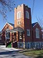
- Grace Episcopal Church (built in 1851)
- Kabletown Church (built in 1861)
- Brown Shugart House (built in 1885)
Images for kids
-
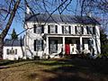
Mount Ellen
-

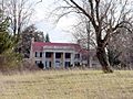
Happy Retreat
-
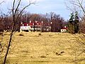
Blakeley
-
Claymont Court
-
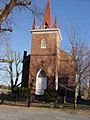
Grace Episcopal Church
-
Kabletown Church


See also
 In Spanish: Condado de Jefferson (Virginia Occidental) para niños
