
List of Great Basin watersheds facts for kids
The Great Basin is a huge, dry area in North America. It's special because all the water that falls there, like rain or snow, stays within the basin. It doesn't flow out to the ocean! Instead, it collects in lakes or sinks into the ground. This type of area is called an endorheic basin, which means "internal drainage."
Imagine a giant bathtub with no drain leading outside. All the water stays inside! That's kind of how the Great Basin works. It's the biggest area like this in North America. This article will tell you about some of the main places where water collects in this unique region, especially those areas larger than 500 square miles (about 1,300 square kilometers).

Contents
Water Basins in Utah
Utah has some of the largest water collection areas in the Great Basin.
Great Salt Lake: Utah's Giant Lake
The Great Salt Lake is the biggest saltwater lake in the Western Hemisphere. It's so big that parts of its basin stretch into Idaho and Wyoming! It covers a massive area of about 19,162 square miles (49,629 square kilometers).
- Bear River: The Bear River is a major river that flows into the Great Salt Lake. It's about 7,561 square miles (19,583 square kilometers).
- Bear Lake: This beautiful lake, Bear Lake, is also part of the Bear River system. It's shared by Idaho and Utah.
- Weber River: The Weber River also feeds into the Great Salt Lake, covering about 2,093 square miles (5,421 square kilometers).
- Jordan River: The Jordan River flows from Utah Lake into the Great Salt Lake. Its basin is about 3,551 square miles (9,197 square kilometers).
- Utah Lake: This large freshwater lake, Utah Lake, is a key part of the Jordan River system. It's about 2,536 square miles (6,568 square kilometers).
- Provo River: The Provo River is one of the rivers that flows into Utah Lake.
- Spanish Fork: Another important river feeding Utah Lake is the Spanish Fork.
- Utah Lake: This large freshwater lake, Utah Lake, is a key part of the Jordan River system. It's about 2,536 square miles (6,568 square kilometers).
Bonneville Salt Flats: A Dry Lakebed
The Bonneville Salt Flats are famous for land speed records! This huge, flat area was once a giant lake called Lake Bonneville. Now, it's mostly a dry lakebed, but it's still a major drainage area, about 8,602 square miles (22,274 square kilometers). It stretches into Nevada.
- Snake Valley: Snake Valley is a large area within the Bonneville Salt Flats basin, shared by Nevada and Utah.
Sevier Lake: Utah's Other Large Basin
The Sevier Lake basin is another significant area in Utah, covering about 9,387 square miles (24,312 square kilometers).
- Sevier River: The Sevier River is the main river flowing into Sevier Lake, with its own large drainage area of about 8,591 square miles (22,248 square kilometers).
Water Basins in Nevada
Nevada has many large, dry lakebeds and river systems that stay within the Great Basin.
Carson Sink: A Huge Dry Lakebed
The Carson Sink is a very large dry lakebed, covering about 19,839 square miles (51,382 square kilometers), and extends into California.
- Humboldt River: The Humboldt River is the longest river in Nevada and flows into the Carson Sink. Its basin is about 16,753 square miles (43,390 square kilometers).
- Reese River: The Reese River is a major tributary of the Humboldt River.
- Carson River: The Carson River also flows into the Carson Sink, with a basin of about 2,585 square miles (6,695 square kilometers).
Black Rock Desert: Another Famous Dry Lakebed
The Black Rock Desert is well-known for events like Burning Man. This vast, dry area is about 8,509 square miles (22,038 square kilometers) and reaches into Oregon.
- Quinn River: The Quinn River is the main river system that drains into the Black Rock Desert, covering about 7,590 square miles (19,658 square kilometers).
Pyramid Lake: A Beautiful Blue Lake
Pyramid Lake is a large, beautiful lake in Nevada, about 3,112 square miles (8,060 square kilometers).
- Truckee River: The Truckee River flows from Lake Tahoe into Pyramid Lake. Its basin is about 2,332 square miles (6,040 square kilometers).
- Lake Tahoe: This famous, deep blue lake, Lake Tahoe, is shared by California and Nevada and is the source of the Truckee River.
Walker Lake: A Shrinking Desert Lake
Walker Lake is another significant lake in Nevada, about 3,561 square miles (9,223 square kilometers).
- Walker River: The Walker River feeds Walker Lake, with a basin of about 2,753 square miles (7,130 square kilometers).
Water Basins in Oregon
Oregon also has parts of the Great Basin, with several important lakes.
Malheur Lake: A Large Wetland Area
Malheur Lake is a large, shallow lake in Oregon, known for its wetlands and birdlife. Its basin is about 3,062 square miles (7,930 square kilometers).
- Silvies River: The Silvies River is a key river flowing into Malheur Lake.
Harney Lake: Malheur's Neighbor
Harney Lake is right next to Malheur Lake and is also a large basin, about 1,810 square miles (4,688 square kilometers).
- Silver Creek: Silver Creek is a major waterway for Harney Lake.
Lake Abert: A Salty Oregon Lake
Lake Abert is a very salty lake in Oregon, covering about 897 square miles (2,323 square kilometers).
- Chewaucan River: The Chewaucan River flows into Lake Abert.
Water Basins in California
California's Great Basin areas include some very dry and hot regions.
Honey Lake: A Seasonal Lake
Honey Lake is a large, shallow lake in California that often dries up in summer. Its basin is about 1,905 square miles (4,934 square kilometers).
- Susan River: The Susan River flows into Honey Lake.
Mono Lake: A Unique Salty Lake
Mono Lake is a very old and salty lake in California, famous for its unique "tufa towers" (limestone formations). Its basin is about 785 square miles (2,033 square kilometers).
Owens Lake: A Dried-Up Lake
Owens Lake was once a large lake but is now mostly dry due to water being diverted for cities. Its basin is about 3,501 square miles (9,067 square kilometers).
- Owens River: The Owens River used to be the main source of water for Owens Lake.
Amargosa River: A Desert River
The Amargosa River is a unique desert river that mostly flows underground or as a dry wash, but its basin is huge, about 8,785 square miles (22,753 square kilometers). It flows towards Death Valley.
- Death Valley Wash: This wash is a significant part of the Amargosa River system, leading into Death Valley.
Salton Sea: California's Largest Lake
The Salton Sea is California's largest lake, though it's an accidental one, formed by a Colorado River flood. It's very salty and has faced environmental challenges. Its basin, known as the Salton Sink, is about 6,022 square miles (15,597 square kilometers).
- Whitewater River: The Whitewater River flows into the Salton Sea.
- New River: The New River also flows into the Salton Sea, coming from Mexico.
Water Basins in Mexico
A small part of the Great Basin's drainage extends into Mexico.
Laguna Salada: A Mexican Dry Lakebed
Laguna Salada is a large dry lakebed in Mexico, part of the larger Salton Sink system. It covers about 1,680 square miles (4,351 square kilometers).
Images for kids
-
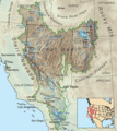
Map of the Great Basin, showing where all the water stays inside!
See also
de:Great Basin Basin gránde fr:Great Basin fi:Great Basin
