List of rivers of the Great Basin facts for kids
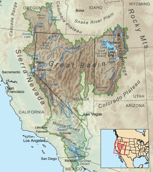
The Great Basin is a huge, dry region in the western United States. It's special because its rivers and streams don't flow into the ocean. Instead, they flow into lakes that have no outlets, or they simply dry up in the desert. This article lists the important rivers in this unique area.
Rivers of the Great Basin
The Great Basin is made up of many connected watersheds. A watershed is an area of land where all the water drains into a single river, lake, or ocean. The Great Basin is surrounded by other big river systems. To the west are the Sacramento and San Joaquin rivers. To the north are the Columbia and Snake rivers. To the south and east are the Colorado and Green rivers.
Most of the important rivers in the Great Basin are found in Utah and Nevada. The longest rivers here are the Bear River (about 350 miles long), the Sevier River (about 385 miles long), and the Humboldt River (about 290 miles long). The Humboldt River can seem even longer, up to 390 miles, because it twists and turns so much.
Here are some of the main rivers in the Great Basin:
- Amargosa River – This river flows into Death Valley in Nevada and California. It is about 185 miles (298 km) long.
- American Fork – This river flows into Utah Lake in Utah.
- Bear River – The longest river in the Great Basin, it flows into the Great Salt Lake. It runs through Utah, Wyoming, and Idaho, and is about 350 miles (563 km) long.
- Malad River (Idaho, Utah)
- Logan River (Utah)
- Little Bear River (Utah)
- Blacksmith Fork River (Utah)
- Chewaucan River – This river flows into Lake Abert in Oregon. It is about 53 miles (85 km) long.
- Dairy Creek (Oregon)
- Elder Creek (Oregon)
- Bear Creek (Oregon)
- Carson River – This river flows into the Carson Sink in Nevada. It is about 131 miles (211 km) long.
- Donner und Blitzen River – This river flows into the Harney Basin in Oregon. It is about 61 miles (98 km) long.
- Humboldt River – This river flows into the Humboldt Sink in Nevada. It is about 151 miles (243 km) long, but its winding path makes it seem longer.
- Jordan River – This river connects Utah Lake to the Great Salt Lake in Utah. It is about 51.4 miles (82.7 km) long.
- Mojave River – This river flows through the Mojave Desert in California. It is about 110 miles (177 km) long.
- Owens River – This river flows through the Owens Valley in California. It is about 183 miles (295 km) long.
- Provo River – This river flows into Utah Lake in Utah. It is about 80 miles (129 km) long.
- Quinn River – This river flows into the Black Rock Desert in Nevada. It is about 110 miles (177 km) long.
- Salton Sea – The Salton Sea is a large, shallow, salty lake in California. Several rivers flow into it.
- Sevier River – This river flows into Sevier Lake in Utah. It is about 385 miles (619 km) long, making it one of the longest in the Great Basin.
- East Fork Sevier River
- Beaver River
- San Pitch River
- Silvies River – This river flows into the Harney Basin in Oregon. It is about 119 miles (192 km) long.
- Susan River – This river flows into Honey Lake in California. It is about 20 miles (32 km) long.
- Spanish Fork – This river flows into Utah Lake in Utah. It is about 20 miles (32 km) long.
- Soldier Creek
- Thistle Creek
- Truckee River – This river flows from California into Pyramid Lake in Nevada. It is about 121 miles (195 km) long.
- Walker River – This river flows into Walker Lake in Nevada. It is about 62 miles (100 km) long.
- East Walker River
- West Walker River
- Little Walker River
- Weber River – This river flows into the Great Salt Lake in Utah. It is about 125 miles (201 km) long.
More Information
 | Valerie Thomas |
 | Frederick McKinley Jones |
 | George Edward Alcorn Jr. |
 | Thomas Mensah |


