List of islands of Hawaii facts for kids
|
Native name:
Mokupuni o Hawai‘i
|
|
|---|---|
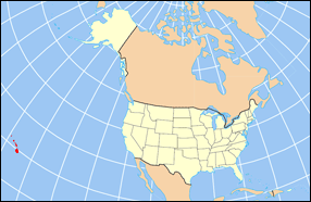
Location of Hawaii within the United States
|
|
| Geography | |
| Location | North Pacific |
| Archipelago | Hawaiian Islands |
| Total islands | Approximately 132 Islands (including 4 of the Midway Atoll) |
| Major islands | Hawaiʻi, Maui, Kahoʻolawe. Lānaʻi, Molokaʻi, Oʻahu, Kauaʻi, Niʻihau |
| Area | 6,423 sq mi (16,640 km2) |
| Length | 1,500 mi (2,400 km) |
| Coastline | 750 mi (1,210 km) |
| Highest point | 13,796 ft (4,205 m) (Mauna Kea) |
| Administration | |
|
United States
|
|
| State | Hawaii (excluding the federally governed Midway Atoll) |
| Demographics | |
| Population | 1,455,271 (2020) |
Hawaii is a special state in the United States because it's made up entirely of islands! It has the fourth-longest ocean coastline in the country, stretching about 750 miles (1,207 km). The chain of islands goes on for about 1,500 miles (2,414 km) from the biggest island, Hawaiʻi, all the way to the Kure Atoll in the north.
Even though Midway Atoll is near Hawaii, it's not officially part of the state. It's managed by the U.S. government, not by Hawaii itself.
Hawaii has five main areas called counties. Each island belongs to one of these counties. For example, Honolulu County manages not only the main island of Oʻahu but also many smaller islands far to the northwest. The state usually talks about eight main islands: Hawaiʻi, Maui, Kahoʻolawe, Lānaʻi, Molokaʻi, Oʻahu, Kauaʻi, and Niʻihau.
Hawaii officially recognizes 137 islands. This number includes tiny islets, rocks, and coral reefs that might not even show up on maps. Some islands, like Shark and Skate islands, have even disappeared due to erosion.
Most of Hawaii's islands are not lived on. Niʻihau is the westernmost island with people, but only about 130 native residents live there. No one else is allowed to visit. All the islands west of Niʻihau are empty and are now part of a special protected area called the Papahānaumokuākea Marine National Monument.
The island of Oʻahu is home to over one million people, which is about 70% of Hawaii's total population. The island of Hawaiʻi, often called the "Big Island," is the largest. It covers about 4,028 square miles (10,432 km²), which is more than half of the state's land!
People first settled these islands around 300 AD. They were brave Polynesian explorers who traveled long distances by sea. The first European to arrive was British captain James Cook in 1778. The islands were independent until 1898 when they became a U.S. territory. Finally, on August 21, 1959, Hawaii became the 50th state of the United States.
Contents
How Hawaii's Islands Were Formed
The Hawaiian Islands are actually the tops of huge underwater mountains. These mountains were created by volcanoes! They formed over a "hotspot" in the Earth's deep mantle. Imagine the Earth's plates slowly moving over a fixed spot where hot magma pushes up. As the Pacific plate moved northwest, new islands formed over the hotspot.
The islands in the northwest are older. They have been exposed to wind and waves for longer, so they are smaller due to erosion. Scientists can tell how old the islands are by studying their rocks. For example, the Kure Atoll in the far northwest is about 28 million years old. But the island of Hawaiʻi, in the southeast, is only about 400,000 years old. It's still growing with active volcanoes, making it one of the most active hotspots on Earth!
Hawaiʻi County: The Big Island

Hawaiʻi County is all about the island of Hawaiʻi. This island is often called the "Big Island" so people don't confuse it with the state of Hawaii. It's huge, covering about 4,028 square miles (10,432 km²). That's bigger than all the other Hawaiian islands put together! It's also the largest island in the United States.
The Big Island is home to Mauna Kea, the state's highest mountain, which is about 13,803 feet (4,207 meters) tall. Hawaiʻi County has 27 islands in total and about 185,079 people live there.
| Island | Coordinates |
|---|---|
| Coconut Island (Moku Ola) | 19°43′57″N 155°04′17″W / 19.73250°N 155.07139°W |
| Hawaiʻi | 19°30′02″N 155°30′02″W / 19.50056°N 155.50056°W |
| Kaulaʻināiwi Island | 19°44′06″N 155°04′21″W / 19.73500°N 155.07250°W |
| Keaoi Island | 19°16′15″N 155°15′24″W / 19.27083°N 155.25667°W |
| Mahikea Island | 19°44′16″N 155°01′54″W / 19.73778°N 155.03167°W |
| Mokuhonu | 18°56′49″N 155°41′52″W / 18.94694°N 155.69778°W |
| Mokupuku | 20°11′43″N 155°42′09″W / 20.19528°N 155.70250°W |
| Paʻakea | 18°58′10″N 155°36′52″W / 18.96944°N 155.61444°W |
| Paokalani Island | 20°11′42″N 155°42′19″W / 20.19500°N 155.70528°W |
| Pulehua Island | 18°58′00″N 155°37′23″W / 18.96667°N 155.62306°W |
| Reeds Island | 19°43′38″N 155°05′53″W / 19.72722°N 155.09806°W |
Honolulu County: The Capital Island
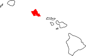
Honolulu County is special because it includes both the big city of Honolulu (which is Hawaii's capital) and the rest of the island of Oʻahu. It also manages the Northwestern Hawaiian Islands, except for Midway Atoll.
Oʻahu is the third largest island, about 596.7 square miles (1,545 km²). It's also the most populated, with about 70% of all Hawaiians living there! Honolulu County has 63 islands in total, and 32 of those are part of the Northwestern Hawaiian Islands.
| Island | Coordinates |
|---|---|
| Ahu O Laka Island | 21°27′59″N 157°48′37″W / 21.46639°N 157.81028°W |
| Coconut Island (Mokuoloe) | 21°26′01″N 157°47′18″W / 21.43361°N 157.78833°W |
| Ford Island | 21°22′00″N 157°57′53″W / 21.36667°N 157.96472°W |
| Kapapa Island | 21°28′48″N 157°48′05″W / 21.48000°N 157.80139°W |
| Mānana Island | 21°19′54″N 157°39′35″W / 21.33167°N 157.65972°W |
| Mokoliʻi | 21°30′46″N 157°49′57″W / 21.51278°N 157.83250°W |
| Moku Manu | 21°28′23″N 157°43′23″W / 21.47306°N 157.72306°W |
| Moku Nui | 21°22′16″N 157°57′08″W / 21.37111°N 157.95222°W |
| Oʻahu | 21°26′00″N 157°58′00″W / 21.43333°N 157.96667°W |
| Popoia Island | 21°24′11″N 157°43′24″W / 21.40306°N 157.72333°W |
| Sand Island | 21°18′30″N 157°53′00″W / 21.30833°N 157.88333°W |
Northwestern Hawaiian Islands: Remote and Protected
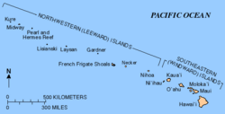
The Northwestern Hawaiian Islands are a group of small islands and atolls (ring-shaped coral reefs) located northwest of the main islands of Kauaʻi and Niʻihau. All these islands are managed by Honolulu County.
These islands are very small, adding up to only about 3.1 square miles (8 km²) of land. No one lives on them permanently. They are important for wildlife and are part of a large marine protected area.
Midway Atoll is a group of four small islands. It used to have military people living there. It's very far northwest and even has a different time zone! Because of its military past, Midway Atoll is managed by the U.S. federal government, not by Hawaii.
- Indicates an island that is part of the Midway Atoll
| Island | Coordinates |
|---|---|
| Disappearing Island | 23°42′58″N 166°08′10″W / 23.71601°N 166.13602°W |
| Eastern Island | 28°12′35″N 177°19′46″W / 28.20985°N 177.32933°W |
| East Island | 23°44′48″N 166°08′58″W / 23.74675°N 166.14954°W |
| French Frigate Shoals | 23°44′56″N 166°08′46″W / 23.74889°N 166.14611°W |
| Gardner Pinnacles | 25°00′01″N 167°55′00″W / 25.00028°N 167.91667°W |
| Green Island | 28°23′40″N 178°17′51″W / 28.39444°N 178.29750°W |
| Kure Atoll | 28°25′00″N 178°20′00″W / 28.41667°N 178.33333°W |
| Laysan Island | 25°46′15″N 171°44′15″W / 25.77083°N 171.73750°W |
| La Perouse Pinnacle | 23°44′50″N 166°09′32″W / 23.74714°N 166.15881°W |
| Lisianski Island | 26°02′00″N 174°00′01″W / 26.03333°N 174.00028°W |
| Maro Reef | 25°24′54″N 170°35′24″W / 25.41500°N 170.59000°W |
| Midway Atoll | 28°14′12″N 177°22′15″W / 28.23660°N 177.37092°W |
| Necker Island | 23°35′00″N 164°42′00″W / 23.58333°N 164.70000°W |
| Nihoa | 23°06′00″N 161°58′00″W / 23.10000°N 161.96667°W |
| North Island | 27°55′00″N 175°44′00″W / 27.91667°N 175.73333°W |
| Pearl Atoll | 27°50′00″N 175°50′00″W / 27.83333°N 175.83333°W |
| Sand Island1 | 28°12′34″N 177°22′43″W / 28.20955°N 177.37851°W |
| Sand Island2 | 27°47′09″N 175°51′40″W / 27.78583°N 175.86111°W |
| Southeast Island | 27°46′51″N 175°48′42″W / 27.78083°N 175.81167°W |
| Spit Island | 28°12′23″N 177°20′59″W / 28.20637°N 177.34967°W |
| Tern Island | 23°45′45″N 166°09′55″W / 23.76238°N 166.16516°W |
Kalawao County: Smallest County
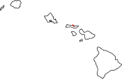
Kalawao County is unique because it's the smallest county in the United States by land area. It's so small that it's often left off maps! It shares the island of Molokaʻi with Maui County.
Kalawao County only takes up a tiny part of Molokaʻi's northern shore. It has a very small population of about 90 people.
| Island | Coordinates |
|---|---|
| Molokai | 21°11′49″N 156°58′02″W / 21.19694°N 156.96722°W |
| Mōkapu | 21°11′12″N 156°55′37″W / 21.18667°N 156.92694°W |
| Huelo | 21°10′27″N 156°55′09″W / 21.17417°N 156.91917°W |
| ʻOkala Island | 21°10′40″N 156°55′55″W / 21.17778°N 156.93194°W |
Kauaʻi County: The Garden Isle
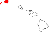
Kauaʻi County is the northwesternmost county in Hawaii, not counting the very distant Northwestern Hawaiian Islands. It includes two main islands: Kauaʻi and Niʻihau.
Kauaʻi is the fourth largest island in Hawaii, about 562.3 square miles (1,456 km²). Most of the county's population lives on Kauaʻi. The remaining residents live on Niʻihau. Lehua and Kaʻula are two other small, uninhabited islands in this county. Kaʻula is the westernmost Hawaiian island that is not part of the Northwestern Hawaiian Island chain. Kauaʻi County has eight islands in total.
| Island | Coordinates |
|---|---|
| Kaʻula | 21°39′40″N 160°32′30″W / 21.66111°N 160.54167°W |
| Kauaʻi | 21°56′37″N 159°29′38″W / 21.94361°N 159.49389°W |
| Lehua | 22°01′10″N 160°06′02″W / 22.01944°N 160.10056°W |
| Mokuaeae | 22°14′16″N 159°24′20″W / 22.23778°N 159.40556°W |
| Niʻihau | 21°54′24″N 160°08′57″W / 21.90667°N 160.14917°W |
| Puʻukole | 22°00′27″N 160°05′49″W / 22.00750°N 160.09694°W |
Maui County: The Valley Isle and More
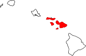
Maui County is made up of four of Hawaii's main islands: Maui, Kahoʻolawe, Lānaʻi, and Molokaʻi.
The island of Maui has the most residents in this county, and it's the second largest island in the state. It covers about 727.2 square miles (1,883 km²). Kahoʻolawe is the largest island in Hawaii with no permanent residents, covering about 44.6 square miles (115.5 km²).
Lānaʻi has a population of 3,193, and Molokaʻi has 7,404 people. Molokaʻi is the only island in Hawaii that is split between two counties (Maui County and Kalawao County). Maui County has 59 named islands in total.
| Island | Coordinates |
|---|---|
| Āhole Rock | 20°38′59″N 156°03′27″W / 20.64972°N 156.0575°W |
| Ālau Island | 20°43′53″N 155°58′49″W / 20.73139°N 155.98028°W |
| Kahoʻolawe | 20°33′00″N 156°36′00″W / 20.55000°N 156.60000°W |
| Kaneapua | 20°44′14″N 156°58′08″W / 20.73722°N 156.96889°W |
| Lānaʻi | 20°50′30″N 156°55′04″W / 20.84167°N 156.91778°W |
| Maui | 20°34′55″N 156°22′30″W / 20.58194°N 156.37500°W |
| Mokuhoʻoniki | 21°08′09″N 156°42′21″W / 21.13583°N 156.70583°W |
| Molokaʻi | 20°43′53″N 155°58′49″W / 20.73139°N 155.98028°W |
| Molokini | 20°38′01″N 156°29′50″W / 20.63361°N 156.49722°W |
| Moku Naio | 20°44′28″N 156°58′10″W / 20.74111°N 156.96944°W |
| Nanahoa | 20°49′43″N 156°59′43″W / 20.82861°N 156.99528°W |
| Puupehe | 20°44′15″N 156°53′35″W / 20.73750°N 156.89306°W |
 | Leon Lynch |
 | Milton P. Webster |
 | Ferdinand Smith |

