Manassa, Colorado facts for kids
Quick facts for kids
Town of Manassa, Colorado
|
|
|---|---|
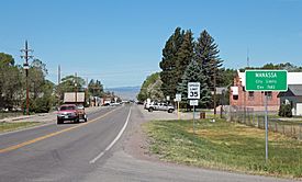
Main Street in Manassa looking west
|
|
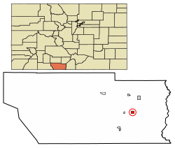
Location of Manassa in Conejos County, Colorado.
|
|
| Country | United States |
| State | Colorado |
| County | Conejos |
| Founded | 1851 |
| Incorporated (town) | June 6, 1889 |
| Government | |
| • Type | Statutory Town |
| Area | |
| • Total | 0.93 sq mi (2.41 km2) |
| • Land | 0.93 sq mi (2.41 km2) |
| • Water | 0.00 sq mi (0.00 km2) |
| Elevation | 7,691 ft (2,344 m) |
| Population
(2020)
|
|
| • Total | 947 |
| • Density | 1,018/sq mi (392.9/km2) |
| Time zone | UTC-7 (Mountain (MST)) |
| • Summer (DST) | UTC-6 (MDT) |
| ZIP code |
81141 (PO Box)
|
| Area code(s) | 719 |
| FIPS code | 08-48060 |
| GNIS feature ID | 2412937 |
The Town of Manassa is a small town in Colorado, United States. It was founded in 1851. Manassa is the biggest town in Conejos County. In 2020, about 947 people lived there.
Contents
- Where is Manassa Located?
- Manassa's History
- Railroad Connections
- Weather and Climate
- People in Manassa
- Manassa's Streets
- Pioneer Days Celebration
- Getting Around Manassa
- Schools in Manassa
- Higher Education Opportunities
- Churches in Manassa
- Hospitals and Healthcare
- Local Banking Services
- Fun Places to Visit Near Manassa
- Famous People from Manassa
- Manassa Turquoise Mine
- Nearby Federal Lands
- Local News and Media
- See also
Where is Manassa Located?
Manassa is a community where people farm and raise animals. It is in the eastern part of Conejos County, Colorado. The town is in a large area called the San Luis Valley in south-central Colorado.
Manassa is very high up, about 7,683 feet (2,342 meters) above sea level. The land in town is flat. Nearby, you can find rolling hills. Farther away, there are tall mountains, some over 14,000 feet (4,267 meters) high. These include the Sangre de Cristo Range to the east and the San Juan Mountains to the west.
Blanca Peak is a very important mountain in the area. It is about 37 miles (60 km) northeast of Manassa. This huge mountain stands over the Great Sand Dunes National Park and Preserve.
The San Luis Valley is a big, high-up area. It covers about 8,000 square miles (20,720 km2). The average height of the valley is 7,664 feet (2,336 meters) above sea level. The Rio Grande river flows through the valley, heading south into New Mexico. The valley has a cold desert climate. But it has a lot of water from the Rio Grande and underground water sources.
Manassa's History
People from northern New Mexico first settled the Manassa area in the mid-1800s. Many early settlers were descendants of Spanish colonists who arrived in New Mexico in 1598. Today, about half of Manassa's residents have Spanish and Mexican family roots.
Most other residents are descendants of Mormon pioneers. These pioneers founded Manassa in 1879. They named the town after Manasseh, a son of the Israelite Joseph. The Mormons bought land for the town from Hispanic settlers.
The settlers chose the land because they thought a railroad would be built nearby. However, the railroad ended up going through Romeo, which is just three miles west of Manassa.
Railroad Connections
The Colorado Pacific Rio Grande Railroad is a train line that runs in south-central Colorado. It uses 154 miles (248 km) of old Denver and Rio Grande Western Railroad tracks. The railroad has three lines that start from Alamosa. It connects with the Union Pacific Railroad in Walsenburg. A large part of this railroad is in the San Luis Valley. In 2022, a person named Stefan Soloviev bought the railroad.
Weather and Climate
Manassa is about 0.93 square miles (2.4 square kilometers) in size, and it's all land.
The town has a semi-arid climate. This means it has cold, dry winters. The summers are warm and a bit wetter.
| Climate data for Manassa, Colorado (1991–2020 normals, extremes 1893–present) | |||||||||||||
|---|---|---|---|---|---|---|---|---|---|---|---|---|---|
| Month | Jan | Feb | Mar | Apr | May | Jun | Jul | Aug | Sep | Oct | Nov | Dec | Year |
| Record high °F (°C) | 64 (18) |
69 (21) |
74 (23) |
82 (28) |
95 (35) |
95 (35) |
94 (34) |
95 (35) |
89 (32) |
82 (28) |
78 (26) |
68 (20) |
95 (35) |
| Mean maximum °F (°C) | 48.6 (9.2) |
53.2 (11.8) |
65.4 (18.6) |
72.5 (22.5) |
80.3 (26.8) |
86.0 (30.0) |
88.3 (31.3) |
85.3 (29.6) |
81.7 (27.6) |
75.2 (24.0) |
63.6 (17.6) |
51.8 (11.0) |
89.0 (31.7) |
| Mean daily maximum °F (°C) | 34.9 (1.6) |
41.3 (5.2) |
52.6 (11.4) |
60.4 (15.8) |
69.1 (20.6) |
78.6 (25.9) |
80.6 (27.0) |
78.6 (25.9) |
73.3 (22.9) |
63.1 (17.3) |
48.8 (9.3) |
35.8 (2.1) |
59.8 (15.4) |
| Daily mean °F (°C) | 19.9 (−6.7) |
26.9 (−2.8) |
36.8 (2.7) |
44.1 (6.7) |
52.8 (11.6) |
61.3 (16.3) |
64.9 (18.3) |
62.9 (17.2) |
56.5 (13.6) |
45.7 (7.6) |
32.9 (0.5) |
21.0 (−6.1) |
43.8 (6.6) |
| Mean daily minimum °F (°C) | 5.0 (−15.0) |
12.5 (−10.8) |
20.9 (−6.2) |
27.9 (−2.3) |
36.5 (2.5) |
44.0 (6.7) |
49.2 (9.6) |
47.2 (8.4) |
39.7 (4.3) |
28.2 (−2.1) |
17.0 (−8.3) |
6.1 (−14.4) |
27.8 (−2.3) |
| Mean minimum °F (°C) | −11.2 (−24.0) |
−7.8 (−22.1) |
3.3 (−15.9) |
11.6 (−11.3) |
22.0 (−5.6) |
32.5 (0.3) |
41.4 (5.2) |
39.4 (4.1) |
26.6 (−3.0) |
10.4 (−12.0) |
−1.3 (−18.5) |
−11.6 (−24.2) |
−16.2 (−26.8) |
| Record low °F (°C) | −37 (−38) |
−32 (−36) |
−22 (−30) |
−9 (−23) |
9 (−13) |
20 (−7) |
30 (−1) |
27 (−3) |
13 (−11) |
−7 (−22) |
−28 (−33) |
−33 (−36) |
−37 (−38) |
| Average precipitation inches (mm) | 0.21 (5.3) |
0.22 (5.6) |
0.43 (11) |
0.53 (13) |
0.59 (15) |
0.40 (10) |
1.08 (27) |
1.58 (40) |
1.12 (28) |
0.67 (17) |
0.49 (12) |
0.43 (11) |
7.75 (197) |
| Average snowfall inches (cm) | 4.6 (12) |
3.0 (7.6) |
5.5 (14) |
3.6 (9.1) |
0.4 (1.0) |
0.0 (0.0) |
0.0 (0.0) |
0.0 (0.0) |
0.0 (0.0) |
2.5 (6.4) |
4.5 (11) |
5.6 (14) |
29.7 (75) |
| Average precipitation days (≥ 0.01 in) | 2.3 | 2.7 | 3.0 | 3.3 | 4.0 | 3.6 | 8.6 | 9.3 | 6.8 | 4.0 | 2.8 | 2.7 | 53.1 |
| Average snowy days (≥ 0.1 in) | 2.7 | 2.3 | 2.4 | 1.7 | 0.4 | 0.0 | 0.0 | 0.0 | 0.0 | 1.0 | 1.8 | 2.7 | 15.0 |
| Source: NOAA | |||||||||||||
People in Manassa
| Historical population | |||
|---|---|---|---|
| Census | Pop. | %± | |
| 1880 | 250 | — | |
| 1890 | 642 | 156.8% | |
| 1900 | 739 | 15.1% | |
| 1910 | 788 | 6.6% | |
| 1920 | 906 | 15.0% | |
| 1930 | 953 | 5.2% | |
| 1940 | 1,008 | 5.8% | |
| 1950 | 832 | −17.5% | |
| 1960 | 831 | −0.1% | |
| 1970 | 814 | −2.0% | |
| 1980 | 945 | 16.1% | |
| 1990 | 988 | 4.6% | |
| 2000 | 1,042 | 5.5% | |
| 2010 | 991 | −4.9% | |
| 2020 | 947 | −4.4% | |
In 2000, there were 1,042 people living in Manassa. These people lived in 362 households, with 280 of them being families. About 41% of households had children under 18. Most households (59%) were married couples.
The population was spread out by age. About 33.7% were under 18. The median age was 31 years old. This means half the people were younger than 31 and half were older.
Manassa's Streets
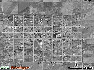
Manassa has wide streets set up in a grid pattern. This design is common in towns started by Mormons. The town is almost one square mile in size. It has eight blocks by eight blocks, making 64 city blocks in total.
The streets running from east to west are numbered First through Ninth. The streets from south to north have names like Main Street. Main Street is also known as State Highway 142. This highway connects Manassa to Romeo and U.S. Route 285 to the west. To the east, it connects to the historic town of San Luis.
Pioneer Days Celebration
Manassa celebrates Pioneer Days every year. This festival is for the whole community and people from all over the San Luis Valley. It features a colorful parade with amazing floats that goes down Main Street for two days.
At the fairgrounds, you can see exciting events like:
- Horse races
- Rodeo events
- Motocross races
- A popular demolition derby
- Fireworks
- Live entertainment
- Barbecues
- A morning 5K run
This festival is one of the best Western heritage events. It has a carnival with rides like the Tilt-a-Whirl and a ferris wheel. There's also live music, a hamburger stand, and vendor booths in Manassa's city park. A special tradition is lighting up the letter "M" painted on a nearby mountain with kerosene. This creates a burning spectacle that lights up the night sky.
Pioneer Days is a celebration of small-town fun and over a century of tradition. It happens every year for two days around July 24. This makes it one of the oldest festivals in Colorado. The 144th celebration was held in 2023. The weekend honors the arrival of Brigham Young and other members of The Church of Jesus Christ of Latter-day Saints in Utah's Great Salt Lake Valley on July 24, 1847. These Mormon pioneers left their home in Nauvoo, Illinois, and traveled west to find a safe place from religious persecution.
Each year, about 10,000 people attend Manassa Pioneer Days each day. People come from many parts of the country to visit family and friends and enjoy the fun.
Getting Around Manassa
If you want to travel to bigger cities, you usually connect through Colorado Springs, Denver, or Albuquerque.
The closest airport with daily flights to Denver is San Luis Valley Regional Airport. It is in Alamosa, about 24 miles (39 km) north of Manassa. Alamosa is the largest town and main trading center for the San Luis Valley.
Schools in Manassa
Students in Manassa go to public schools in the North Conejos School District RE1-J. There is an elementary school right in Manassa. Older students attend Centauri Middle School and Centauri High School. These schools are about 10 miles (16 km) north and west of Manassa, near the town of La Jara. The high school sports teams are called the Falcons, and their colors are red and white.
Higher Education Opportunities
Students from Manassa who want to continue their education close to home can go to Alamosa. Adams State University is in Alamosa, which has about 8,500 people. At Adams State, students can earn college degrees in many different subjects.
Alamosa also has a campus of Trinidad State College. This is a two-year community college. It offers many courses, including Massage, Nursing, Welding, Auto and Diesel Mechanics, and Law Enforcement Training.
Churches in Manassa
Manassa has two churches:
- St. Therese of the Child Jesus Catholic Church
- A meetinghouse for The Church of Jesus Christ of Latter-day Saints
Hospitals and Healthcare
Conejos County Hospital is in La Jara, Colorado, which is in Conejos County. It is a "critical access hospital," meaning it provides important healthcare services in a rural area. The hospital has 17 beds and is a Level IV trauma center. It serves Conejos and Costilla counties in the San Luis Valley. It is the only emergency service provider in this large 2,514 square mile area.
The hospital was built in 1963. It was first run by Mennonites until the 1970s. In 2019, the hospital finished a $6 million expansion. This included upgrading its emergency rooms.
Conejos County Hospital is part of San Luis Valley Health (SLV Health). This is a small hospital network started in 2013. The other hospital in this network is the San Luis Valley Regional Medical Center in Alamosa.
Local Banking Services
The closest bank is in La Jara, Colorado, about 10 miles (16 km) away. This bank is part of Community Banks of Colorado.
The Guadalupe Parish Credit Union is in Antonito, Colorado. It serves members of Our Lady of Guadalupe Parish in Antonito, St. Joseph's Parish in La Jara, and Sangre de Cristo Parish in San Luis.
Fun Places to Visit Near Manassa
Manassa is close to many interesting places:
- Great Sand Dunes National Park and Preserve: Huge sand dunes to explore.
- Cumbres and Toltec Scenic Railroad: A historic train ride through beautiful scenery.
- Colorado Gators Reptile Park: A park with many reptiles.
- Rio Grande Scenic Railroad: Another scenic train ride.
- Fort Garland Museum: A museum about the history of the area.
- UFO Watchtower: A unique spot for those interested in UFOs.
- Stations of the Crosses site in nearby San Luis, Colorado: The oldest town in Colorado.
Our Lady of Guadeloupe Catholic Church is in nearby Conejos. It is about 10 miles (16 km) southwest of Manassa. This church was founded in 1858, 18 years before Colorado became a state. It is the oldest church in Colorado.
Famous People from Manassa
- Jack Dempsey (also known as The Manassa Mauler): He was a famous American professional heavyweight boxing champion. The Jack Dempsey Museum in Manassa honors his memory.
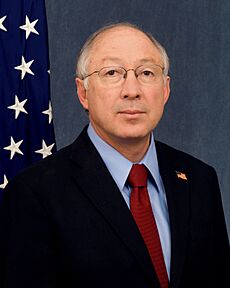
- Ken Salazar: He was appointed by President Joe R. Biden to be the United States Ambassador to Mexico. He was also the former Secretary of the U.S. Department of the Interior and a former U.S. Senator for Colorado. He was first elected Senator in 2004. Before that, he was the Attorney General for the State of Colorado.
- John Salazar: He served as the Commissioner of the Colorado Department of Agriculture from 2011 to 2015. He was also a U.S. Representative for Colorado's 3rd congressional district from 2005 to 2011. John Salazar is Ken Salazar's brother.
Manassa Turquoise Mine
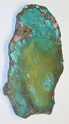
Mantissa turquoise is a special type of stone mined east of Manassa. It is known for its blue-green to green color. It often has golden or brown lines, called a matrix, that are not web-like. The Manassa mine is still active and owned by the King family. Because of this, the turquoise is sometimes called King's Manassa turquoise. Many people love this stone, especially its beautiful green color, which looks great with gold.
This mining site was first used by ancient Pueblo peoples. It was rediscovered in 1890 by a gold prospector named I.P. King. His family still works the mine today. King's Manassa turquoise is most famous for its bright green colors and golden matrices. However, blue and blue-green turquoise has also been found there.
Nearby Federal Lands
The Conejos River is a river about 92.5 miles (149 km) long in south-central Colorado. It flows into the Rio Grande. The river drains a beautiful area of the eastern San Juan Mountains. Fishing for trout is very popular on the Conejos River.
The Rio Grande National Forest is a huge forest in southwestern Colorado. It covers about 1.86 million acres (7,530 square kilometers). This forest includes the San Luis Valley, which is the world's largest farming valley at high elevation. It also has one of the world's largest high deserts near mountains. The Rio Grande river starts in this forest. The Continental Divide runs along most of its western edge. The forest is located in parts of nine counties.
The San Luis Hills WSA are a group of small mountains in Conejos and Costilla counties. They are part of the San Luis Valley in southern Colorado. These hills include the Fairy Hills, Brownie Hills, Piñon Hills, and South Piñon Hills. The highest point in the San Luis Hills is Flat Top, which is 9,206 feet (2,806 meters) high.
The South San Juan Wilderness is a special protected area in the San Juan National Forest. It is located east of Pagosa Springs in southern Colorado. This area is 158,790 acres (64,260 hectares) big. It was made a Wilderness Area by the United States Congress in 1980.
The Conejos, San Juan, and Blanco rivers all begin in this wilderness area. The last known grizzly bear in Colorado was killed here in 1979. Some people believe a few grizzlies might still live there, but there is no strong proof yet.
Local News and Media
Two media sources cover events in and near Manassa:
- The Valley Courier, based in Alamosa.
- The SLV Dweller, a website focused on everything about the San Luis Valley.
See also
 In Spanish: Manassa (Colorado) para niños


