Mauna Loa facts for kids
Quick facts for kids Mauna Loa |
|
|---|---|
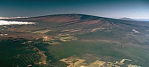
Mauna Loa as seen from the air.
Hualālai is visible in the background. |
|
| Highest point | |
| Elevation | 13,679 ft (4,169 m) |
| Prominence | 7,079 ft (2,158 m) |
| Listing |
|
| Geography | |
| Parent range | Hawaiian Islands |
| Topo map | USGS Mauna Loa |
| Geology | |
| Age of rock | 700,000–1 million |
| Mountain type | Shield volcano |
| Last eruption | November 27 – December 13, 2022 |
| Climbing | |
| First ascent | Ancient times |
| Easiest route | Ainapo Trail |
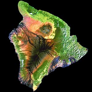
Mauna Loa (which means "Long Mountain" in Hawaiian) is one of five volcanoes that make up the Island of Hawaii in the Pacific Ocean. It is the largest active volcano on Earth by its size and volume. Scientists once thought it was the biggest volcano overall, until the underwater mountain Tamu Massif was found to be larger. Mauna Loa is a shield volcano, meaning it has gentle slopes, like a warrior's shield lying on the ground. Its peak is about 125 feet (38 meters) lower than its neighbor, Mauna Kea. The lava from Mauna Loa is very fluid and usually flows out calmly, not in big explosions.
Mauna Loa has been erupting for at least 700,000 years. It likely rose above the ocean surface about 400,000 years ago. The volcano gets its molten rock, called magma, from a special spot deep inside the Earth called the Hawaii hotspot. This hotspot has created the entire Hawaiian Island chain over millions of years. Eventually, the Pacific Plate (the part of Earth's crust it sits on) will move Mauna Loa away from this hotspot. In about 500,000 to one million years, the volcano will become inactive.
Mauna Loa's most recent eruption happened from November 27 to December 13, 2022. This was its first eruption since 1984. While no one has been hurt in recent eruptions, past lava flows have destroyed villages. For example, eruptions in 1926 and 1950 caused significant damage. Parts of the city of Hilo are even built on old lava flows from the late 1800s.
Because Mauna Loa can be dangerous to nearby towns, it is part of the Decade Volcanoes program. This program encourages scientists to study the world's most risky volcanoes. The Hawaiian Volcano Observatory has been watching Mauna Loa closely since 1912. Scientists also use observatories near the summit to study the atmosphere and the Sun. These include the Mauna Loa Observatory and the Mauna Loa Solar Observatory. The Hawaii Volcanoes National Park covers the top of Mauna Loa and parts of its sides. It also includes Kīlauea, another active volcano.
Contents
How Mauna Loa Formed
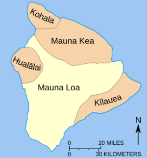
Like all Hawaiian volcanoes, Mauna Loa formed as the Pacific Plate moved over a hot spot in Earth's mantle. This process has been happening for over 70 million years. It created the 3,700-mile (6,000 km) long Hawaiian–Emperor seamount chain. Scientists believe this hotspot has stayed in roughly the same place for a very long time.
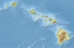
Mauna Loa is one of five volcanoes that make up the island of Hawaiʻi. The oldest volcano on the island is Kohala, which is over a million years old. Kīlauea is the youngest, at about 210,000 to 280,000 years old. Mauna Loa is the second youngest of the five volcanoes on the island. It is between 600,000 and 1 million years old.
Mauna Loa started as an underwater volcano. It slowly grew bigger through many eruptions of lava. About 400,000 years ago, it rose above the sea. Since then, it has erupted many times. There have been 34 recorded eruptions since 1843.
Inside Mauna Loa: Its Structure
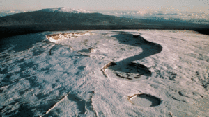
Mauna Loa is the largest active volcano on Earth. It covers an area of 5,271 square kilometers (2,035 sq mi). It makes up more than half of the island of Hawaiʻi. From its base on the ocean floor to its summit, Mauna Loa rises about 9,170 meters (30,085 ft). This is even taller than Mount Everest if measured from its base! Much of the mountain is hidden underwater. Its huge weight also pushes down the Earth's crust beneath it.
Mauna Loa is a classic shield volcano. It looks like a wide, gentle dome. Its slopes are not very steep, only about 12 degrees at their steepest. This shape is because its lava is very fluid and flows easily.
Mauna Loa's Summit and Caldera
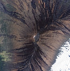
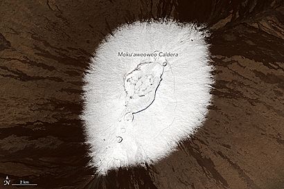
At the very top of Mauna Loa is a large bowl-shaped area called Mokuʻāweoweo. This is its caldera. It is made of three overlapping craters. The largest is about 4.2 by 2.5 kilometers (2.6 by 1.6 mi) wide. Mokuʻāweoweo means "fish-colored" in Hawaiian. This name might come from the fiery red color of eruptions, like the ʻāweoweo fish. This caldera formed between 1,000 and 1,500 years ago. A big eruption emptied a shallow magma chamber below, causing the ground to collapse.
Rift Zones: Where Lava Flows Out
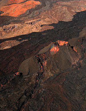
Mauna Loa also has two main "rift zones." These are long cracks in the volcano's sides where lava often erupts. You can see them from the air as lines of old lava flows and small cinder cones. One rift zone goes southwest from the caldera towards the sea for about 60 kilometers (37 mi). The other goes northeast towards Hilo for about 20 kilometers (12 mi). These rift zones are like pathways for magma to reach the surface.
Mauna Loa's Neighbors: Kīlauea and Mauna Kea
Mauna Loa interacts with its nearby volcanoes: Hualālai to the northwest, Mauna Kea to the northeast, and especially Kīlauea to the east. Kīlauea looks like a bulge on Mauna Loa's side. Because of this, people once thought Kīlauea was just a part of Mauna Loa. However, scientists have found that they have their own separate magma chambers. This means they are distinct volcanoes.
Interestingly, when one volcano is very active, the other often has less activity. For example, when Kīlauea was quiet from 1934 to 1952, Mauna Loa was active. But this isn't always true. The 1984 and 2022 eruptions of Mauna Loa both happened while Kīlauea was also erupting. Scientists think that magma moving deep inside Mauna Loa might sometimes affect Kīlauea.
Mauna Loa is slowly sliding eastward. This movement pushes against Kīlauea, causing it to move eastward by about 10 centimeters (4 inches) each year. This interaction has caused large earthquakes in the past. It also created a large area of debris off Kīlauea's side called the Hilina Slump.
Mauna Loa was tall enough to have glaciers during the last ice age, about 25,000 to 15,000 years ago. However, because Mauna Loa has been so active, new lava flows have covered most of the evidence of these ancient glaciers.
Mauna Loa's Eruptive History
Ancient Eruptions
Mauna Loa grew very quickly to become so large. Scientists have studied nearly 200 ancient lava flows. These studies show how fast the volcano grew over hundreds of thousands of years. Some of the oldest rocks found are about 470,000 years old.
Volcanic activity at Mauna Loa seems to follow a pattern. For several hundred years, eruptions are mostly at the summit. Then, activity shifts to the rift zones for several more centuries. This cycle repeats every 1,500 to 2,000 years. This pattern is special to Mauna Loa among Hawaiian volcanoes.
Modern Eruptions and Their Impact
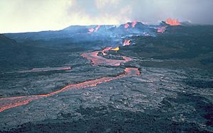
Ancient Hawaiians lived on the island for about 1,500 years. They had few written records of eruptions. The first fully confirmed eruption witnessed by people was in January 1843. Since then, Mauna Loa has erupted 32 times.
Mauna Loa's eruptions are usually calm, not explosive. They often start with lava fountains along a long crack, called a "curtain of fire." This usually happens at the summit or along one of its rift zones. Lava flows from Mauna Loa can be very large and fast. For example, the 1950 eruption sent lava to the ocean in just three hours.
Some eruptions have caused significant damage. In 1926, lava destroyed a village near Hoʻōpūloa. In 1950, the village of Hoʻokena-mauka was permanently covered by lava. The city of Hilo has also been threatened. In 1935, bombs were dropped to try and divert lava flows heading towards Hilo. In 1942, during World War II, an eruption caused a blackout. The military even dropped bombs to try and redirect lava threatening a water source. The 1984 eruption also came very close to Hilo.
The volcano was quiet for its longest recorded period, from 1985 to 2022. But on November 27, 2022, an eruption began at the summit. Lava flows soon moved to the Northeast Rift Zone. Lava fountains shot up to 200 feet (60 meters) high. These flows cut off the road to the Mauna Loa Observatory. By December 8, 2022, the lava flows slowed down and stopped. The eruption officially ended on December 13, 2022.
Volcano Hazards: What to Know
Mauna Loa is a Decade Volcano. This means it's one of 16 volcanoes worldwide that scientists study closely. They are chosen because they have a history of big, damaging eruptions and are near populated areas. The U.S. Geological Survey maps hazard zones on the island. Mauna Loa's active summit and rift zones are in the highest hazard level.
While Hawaiian eruptions rarely cause deaths, they can destroy property. Lava flows from Mauna Loa can be very fast. The 1950 eruption reached the ocean in just four hours, destroying a village and a highway. Hilo is still at risk from future eruptions.
A bigger danger could be a sudden, massive collapse of the volcano's sides. This happened between 100,000 and 200,000 years ago, forming Kealakekua Bay. Large earthquakes could trigger these collapses. This could cause huge landslides and giant tsunamis. For example, in 1975, a part of the volcano called the Hilina Slump moved several meters. This caused a 7.2 magnitude earthquake and a 14-meter (46 ft) tsunami.
Monitoring Mauna Loa
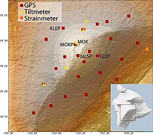
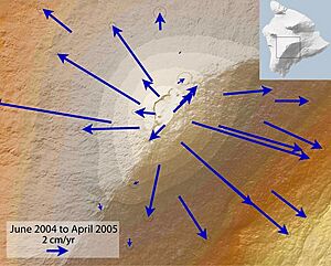
The Hawaiian Volcano Observatory (HVO) was started in 1912. It is the main group that watches and studies Hawaiian volcanoes. Scientists use many tools to monitor Mauna Loa.
Eruptions are almost always preceded by many small earthquakes. Monitoring these earthquakes was the main warning system in the past. It is still very important today. The HVO has seismic stations (which detect earthquakes) all over the island.
Today, the monitoring system also includes GPS stations, tiltmeters, and strainmeters. These tools measure how the ground changes shape. This helps scientists see when magma is building up underground. For example, before the 1975 and 1984 eruptions, the summit expanded by several inches. The HVO also has gas detectors at the summit and a live webcam.
People and Mauna Loa
Early Hawaiian Life
The first Hawaiians lived along the coasts where food and water were easy to find. They built trails to connect their homes to farms and resources. The five volcanic peaks, including Mauna Loa, were considered sacred. The Hawaiian volcano goddess, Pele, is often associated with all volcanic activity on the island.
One important trail was the Ainapo Trail. It went from the village of Kapāpala all the way to Mauna Loa's summit. This journey was difficult and took several days. Ancient Hawaiians likely used this trail during eruptions to leave offerings and prayers for Pele.
First Explorers to the Summit
In 1779, John Ledyard, a corporal with Captain James Cook's expedition, tried to reach Mauna Loa's summit. He and his group had to turn back because the route was too steep and thick with plants.
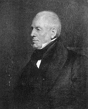
The Scottish botanist Archibald Menzies made three attempts to climb Mauna Loa. In February 1794, on his third try, he succeeded. He got advice from King Kamehameha I and followed the ʻAinapō Trail. Menzies was surprised to find heavy snow and freezing temperatures at the top. He was the first European to reach the summit.
The Wilkes Expedition
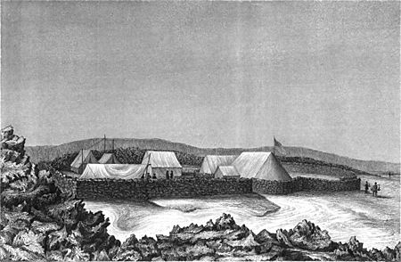
In 1840, the United States Exploring Expedition, led by Lieutenant Charles Wilkes, came to Hawaii. Wilkes decided to climb Mauna Loa. He hired many Hawaiian porters. He tried to make his own path through the forest, which upset the Hawaiians. His group faced snowstorms and altitude sickness.
After much effort, Wilkes and his men reached the rim of Mokuʻāweoweo. They built a stone shelter and set up scientific equipment. They spent weeks at the summit, even celebrating Christmas there. Wilkes tried to measure gravity and the height of Mauna Kea. The ruins of his campsite are now a historic site.
Trails to the Top Today
Today, a shelter stands at the summit, built with stones from Wilkes' camp. In 1916, Mokuʻāweoweo became part of Hawaii Volcanoes National Park. A new trail was built from the park headquarters, offering an easier route. The historic Ainapo Trail was reopened in the 1990s. Another modern route starts from the Saddle Road and goes to the Mauna Loa Observatory.
Mauna Loa's Climate
Trade winds blow across the Hawaiian islands from east to west. Mauna Loa greatly affects the weather. The eastern side of the volcano gets a lot of rain. Hilo is one of the wettest cities in the United States. This rain helps thick forests grow. The western side is much drier.
Higher up the mountain, there is less rain, and the skies are often clear. Temperatures are very low, so precipitation often falls as snow. The summit of Mauna Loa is a "periglacial" region. This means freezing and thawing ice play a big role in shaping the landscape. Mauna Loa has a tropical climate, but it gets colder as you go higher up.
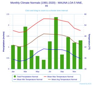
| Climate data for Mauna Loa 5 NNE (1991–2020 normals, extremes 2005–present) | |||||||||||||
|---|---|---|---|---|---|---|---|---|---|---|---|---|---|
| Month | Jan | Feb | Mar | Apr | May | Jun | Jul | Aug | Sep | Oct | Nov | Dec | Year |
| Record high °F (°C) | 66 (19) |
66 (19) |
66 (19) |
67 (19) |
67 (19) |
68 (20) |
69 (21) |
68 (20) |
67 (19) |
66 (19) |
64 (18) |
63 (17) |
69 (21) |
| Mean maximum °F (°C) | 60.1 (15.6) |
58.1 (14.5) |
58.5 (14.7) |
61.0 (16.1) |
63.7 (17.6) |
64.7 (18.2) |
65.3 (18.5) |
64.8 (18.2) |
62.8 (17.1) |
62.9 (17.2) |
59.4 (15.2) |
58.6 (14.8) |
66.6 (19.2) |
| Mean daily maximum °F (°C) | 51.1 (10.6) |
50.1 (10.1) |
50.5 (10.3) |
53.1 (11.7) |
55.5 (13.1) |
57.6 (14.2) |
57.5 (14.2) |
57.3 (14.1) |
56.5 (13.6) |
55.8 (13.2) |
52.4 (11.3) |
51.1 (10.6) |
54.0 (12.2) |
| Daily mean °F (°C) | 43.2 (6.2) |
42.2 (5.7) |
42.7 (5.9) |
44.8 (7.1) |
47.4 (8.6) |
49.3 (9.6) |
49.1 (9.5) |
49.0 (9.4) |
48.6 (9.2) |
47.7 (8.7) |
44.8 (7.1) |
43.4 (6.3) |
46.0 (7.8) |
| Mean daily minimum °F (°C) | 35.4 (1.9) |
34.3 (1.3) |
34.8 (1.6) |
36.5 (2.5) |
39.3 (4.1) |
41.1 (5.1) |
40.7 (4.8) |
40.7 (4.8) |
40.6 (4.8) |
39.6 (4.2) |
37.2 (2.9) |
35.8 (2.1) |
38.0 (3.3) |
| Mean minimum °F (°C) | 28.1 (−2.2) |
27.7 (−2.4) |
29.7 (−1.3) |
31.3 (−0.4) |
32.7 (0.4) |
35.4 (1.9) |
35.2 (1.8) |
35.6 (2.0) |
35.9 (2.2) |
34.8 (1.6) |
31.4 (−0.3) |
30.5 (−0.8) |
25.7 (−3.5) |
| Record low °F (°C) | 22 (−6) |
21 (−6) |
27 (−3) |
28 (−2) |
31 (−1) |
31 (−1) |
30 (−1) |
31 (−1) |
33 (1) |
32 (0) |
29 (−2) |
26 (−3) |
21 (−6) |
| Average precipitation inches (mm) | 1.10 (28) |
1.04 (26) |
1.94 (49) |
0.87 (22) |
0.60 (15) |
0.43 (11) |
1.27 (32) |
2.38 (60) |
0.67 (17) |
1.47 (37) |
1.21 (31) |
1.32 (34) |
14.30 (363) |
| Average precipitation days (≥ 0.01 inch) | 3.9 | 5.7 | 6.8 | 4.1 | 4.1 | 2.1 | 3.7 | 6.0 | 4.8 | 4.9 | 4.6 | 5.6 | 56.3 |
| Source: NOAA | |||||||||||||
Science on the Mountain: Observatories
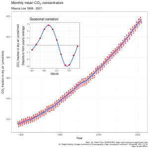
Mauna Loa's high elevation and clear skies make it a great place for scientific observatories. The Mauna Loa Solar Observatory (MLSO) studies the Sun. The NOAA Mauna Loa Observatory (MLO) monitors the Earth's atmosphere. It measures important gases like carbon dioxide, which is a greenhouse gas. These measurements help scientists understand changes in our planet's air.
The Yuan-Tseh Lee Array for Microwave Background Anisotropy (AMiBA) is also located on Mauna Loa. It was built in 2006 to study the cosmic microwave background radiation. This radiation is leftover energy from the very early universe.
See also
 In Spanish: Mauna Loa para niños
- HI-SEAS
- List of mountain peaks of the United States
- List of Ultras of Oceania
- List of Ultras of the United States
- Olympus Mons – The largest volcano in the Solar System
 | Bessie Coleman |
 | Spann Watson |
 | Jill E. Brown |
 | Sherman W. White |


