
McLean County, Illinois facts for kids
Quick facts for kids
McLean County
|
|
|---|---|
.jpg)
|
|

Location within the U.S. state of Illinois
|
|
 Illinois's location within the U.S. |
|
| Country | |
| State | |
| Founded | December 25, 1830 |
| Named for | John McLean |
| Seat | Bloomington |
| Largest city | Bloomington |
| Area | |
| • Total | 1,186 sq mi (3,070 km2) |
| • Land | 1,183 sq mi (3,060 km2) |
| • Water | 2.9 sq mi (8 km2) 0.2% |
| Population
(2020)
|
|
| • Total | 170,954 |
| • Density | 144.14/sq mi (55.654/km2) |
| Time zone | UTC−6 (Central) |
| • Summer (DST) | UTC−5 (CDT) |
| Congressional districts | 16th, 17th |
McLean County is a large county located in the middle-eastern part of Illinois. It's the biggest county in the state when you look at its land area! In 2020, about 170,954 people lived here. The main city and government center, called the county seat, is Bloomington. McLean County is also part of the bigger Bloomington–Normal area.
Contents
How to Say McLean County
When people who live here say "McLean," the second part sounds like "KLAIN," not "KLEEN." So, it's pronounced "muh-KLAIN."
History of McLean County
The first European settlers arrived in the area that would become McLean County around 1821. The very first settlement was called Blooming Grove. It was started in 1822, close to where Bloomington is today.
McLean County was officially created on December 25, 1830. It was formed from a part of Tazewell County. The county was named after John McLean, who was a United States Senator for Illinois. He passed away in 1830.
-
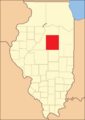
McLean County from the time of its creation to 1837
-
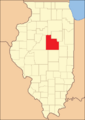
McLean County between 1837 and 1841
-
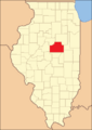
McLean County in 1841, reduced to its present borders


Geography and Land Area
McLean County covers a total area of about 1,186 square miles. Most of this, about 1,183 square miles, is land. Only a small part, 2.9 square miles, is water.
It is the largest county in Illinois by land area. It's also the third largest overall, after Cook and Lake Counties. Those counties have big parts of their area in Lake Michigan. McLean County is actually larger than the entire land area of Rhode Island!
Climate and Weather
| Weather chart for Bloomington, Illinois | |||||||||||||||||||||||||||||||||||||||||||||||
|---|---|---|---|---|---|---|---|---|---|---|---|---|---|---|---|---|---|---|---|---|---|---|---|---|---|---|---|---|---|---|---|---|---|---|---|---|---|---|---|---|---|---|---|---|---|---|---|
| J | F | M | A | M | J | J | A | S | O | N | D | ||||||||||||||||||||||||||||||||||||
|
1.7
31
14
|
1.7
37
18
|
2.9
48
29
|
3.8
61
40
|
4.5
73
51
|
3.9
83
61
|
4
86
65
|
3.8
84
63
|
3
77
54
|
2.7
65
42
|
3.1
49
31
|
2.4
36
20
|
||||||||||||||||||||||||||||||||||||
| temperatures in °F precipitation totals in inches source: The Weather Channel |
|||||||||||||||||||||||||||||||||||||||||||||||
|
Metric conversion
|
|||||||||||||||||||||||||||||||||||||||||||||||
The weather in Bloomington, the county seat, changes a lot throughout the year. In January, the average low temperature is about 14°F. In July, the average high temperature is around 86°F.
The coldest temperature ever recorded was -23°F in January 1985. The hottest was 103°F in June 1988. The county gets the most rain in May, with about 4.52 inches on average. February is usually the driest month.
Neighboring Counties
McLean County shares borders with several other counties:
- Woodford County - northwest
- Livingston County - northeast
- Ford County - east
- Champaign County - southeast
- Piatt County - south
- DeWitt County - south
- Logan County - southwest
- Tazewell County - west
Main Roads and Highways
Many important roads pass through McLean County, connecting it to other parts of Illinois and beyond.
 Interstate 39
 Interstate 55
 Interstate 74
 U.S. Highway 24
 U.S. Highway 51
 U.S. Highway 66
 U.S. Highway 136
 U.S. Highway 150
 Illinois Route 9
 Illinois Route 54
 Illinois Route 122
 Illinois Route 165
 Illinois Route 251
Public Transportation
The county has several ways for people to get around without a car.
- Connect Transit
- SHOW Bus
- Uptown Station
- List of intercity bus stops in Illinois
Population and People
| Historical population | |||
|---|---|---|---|
| Census | Pop. | %± | |
| 1840 | 6,565 | — | |
| 1850 | 10,163 | 54.8% | |
| 1860 | 28,772 | 183.1% | |
| 1870 | 53,988 | 87.6% | |
| 1880 | 60,100 | 11.3% | |
| 1890 | 63,036 | 4.9% | |
| 1900 | 67,843 | 7.6% | |
| 1910 | 68,008 | 0.2% | |
| 1920 | 70,107 | 3.1% | |
| 1930 | 73,117 | 4.3% | |
| 1940 | 73,930 | 1.1% | |
| 1950 | 76,577 | 3.6% | |
| 1960 | 83,877 | 9.5% | |
| 1970 | 104,389 | 24.5% | |
| 1980 | 119,149 | 14.1% | |
| 1990 | 129,180 | 8.4% | |
| 2000 | 150,433 | 16.5% | |
| 2010 | 169,572 | 12.7% | |
| 2020 | 170,954 | 0.8% | |
| 2023 (est.) | 170,441 | 0.5% | |
| U.S. Decennial Census 1790-1960 1900-1990 1990-2000 2010-2019 |
|||
In 2010, about 169,572 people lived in McLean County. The county had about 65,104 households. Most of the people living here were white (84.3%). Other groups included Black or African American (7.3%) and Asian (4.3%). About 4.4% of the population was of Hispanic or Latino background.
Many people in McLean County have German (31.2%), Irish (15.4%), American (11.4%), or English (11.0%) ancestry. The average age of people in the county was 32.1 years old.
Cities, Towns, and Villages
McLean County is home to several communities, from bigger cities to smaller villages.

Cities
- Bloomington (This is the county seat, where the main government offices are)
- Chenoa
- El Paso
- Le Roy
- Lexington
Town
Villages
Census-Designated Place
Other Small Communities
These are other smaller, unincorporated communities in the county.
- Barnes
- Bentown
- Bloomington Heights
- Covell
- Cropsey
- Fletcher
- Funks Grove
- Gillum
- Hendrix
- Holder
- Kerrick
- Laurette
- Lytleville
- Meadows
- Merna
- Osman
- Padua
- Randolph
- Sabina
- Shirley
- Watkins
- Weedman
- Weston
- Yuton
Townships
McLean County is divided into many smaller areas called townships.
- Allin
- Anchor
- Arrowsmith
- Bellflower
- Bloomington
- Bloomington City
- Blue Mound
- Cheney's Grove
- Chenoa
- Cropsey
- Dale
- Danvers
- Dawson
- Downs
- Dry Grove
- Empire
- Funk's Grove
- Gridley
- Hudson
- Lawndale
- Lexington
- Martin
- Money Creek
- Mount Hope
- Normal
- Old Town
- Randolph
- Towanda
- West
- White Oak
- Yates
Ghost Towns
These are places that used to be communities but are no longer inhabited.
- Allin
- Benjaminville
- Kumler
Education in McLean County
McLean County has many school districts that serve students from kindergarten through 12th grade.
- Blue Ridge Community Unit School District 18
- Bloomington School District 87
- El Paso-Gridley Community Unit School District 11
- Gibson City-Melvin-Sibley Community Unit School District 5
- Heyworth Community Unit School District 4
- Le Roy Community Unit School District 2
- Lexington Community Unit School District 7
- McLean County Unit School District 5
- Olympia Community Unit School District 16
- Prairie Central Community Unit School District 8
- Ridgeview Community Unit School District 19
- Tri-Valley Community Unit School District 3
Illinois State University, a large college, is also located in McLean County.
Famous People from McLean County
Many notable individuals have come from McLean County:
- George J. Mecherle – He was the person who started the well-known company State Farm.
- Adlai Stevenson II – He served as the Governor of Illinois and ran for U.S. President twice. He was also an Ambassador to the United Nations.
- Pokey LaFarge – A talented musician and songwriter.
- Bonnie Lou – A famous recording artist and television personality.
- William H. Rowe – A farmer, businessman, and politician.
- Archbishop Fulton J. Sheen – A Catholic Archbishop who hosted a popular TV show called Life is Worth Living in the 1950s and 60s.
See also
 In Spanish: Condado de McLean (Illinois) para niños
