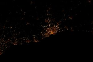
Milwaukee County, Wisconsin facts for kids
Quick facts for kids
Milwaukee County
|
|||
|---|---|---|---|
|
|||
|
|||
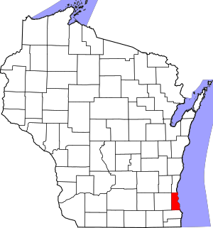
Location within the U.S. state of Wisconsin
|
|||
 Wisconsin's location within the U.S. |
|||
| Country | |||
| State | |||
| Founded | 1835 | ||
| Named for | Milwaukee River | ||
| Seat | Milwaukee | ||
| Largest city | Milwaukee | ||
| Area | |||
| • Total | 1,189 sq mi (3,080 km2) | ||
| • Land | 241 sq mi (620 km2) | ||
| • Water | 948 sq mi (2,460 km2) 80% | ||
| Population
(2020)
|
|||
| • Total | 939,489 | ||
| • Estimate
(2023)
|
916,205 |
||
| • Density | 3,890.5/sq mi (1,502.1/km2) | ||
| Time zone | UTC−6 (Central) | ||
| • Summer (DST) | UTC−5 (CDT) | ||
| Congressional districts | 1st, 4th, 5th | ||
Milwaukee County is a county located in the state of Wisconsin, USA. It is the most populated county in Wisconsin. The county is also the most densely populated, meaning many people live close together.
In 2020, about 939,489 people lived here. The county seat, or main city, is Milwaukee. This city is also the largest in Wisconsin. Milwaukee County was named after the Milwaukee River. It was formed in 1834 when Wisconsin was part of the Michigan Territory. The county officially started working in 1835.
Milwaukee County is a big part of the Milwaukee-Waukesha-West Allis area. This area is important for jobs and living. Unlike other counties in Wisconsin, all parts of Milwaukee County are organized as cities or villages. There are no "towns" here.
The county has 19 cities and villages. After the city of Milwaukee, the largest cities are West Allis, Wauwatosa, Greenfield, Oak Creek, and Franklin. Milwaukee County is also home to two major sports teams: the Milwaukee Bucks (basketball) and the Milwaukee Brewers (baseball). It also hosts Summerfest, the world's largest music festival!
Contents
History of Milwaukee County
Long ago, different Native American tribes lived in the area that is now Milwaukee County. These tribes included the Sauk, Meskwaki (also called "Fox"), Menomonee, Ojibwe, and Potawotami.
In 1818, the land that would become Wisconsin became part of the Michigan Territory. The governor at the time created Brown County. This huge county included all of what is now Milwaukee County.
Milwaukee County was officially created in 1834. It was much larger back then! It included all of what are now Milwaukee, Jefferson, Kenosha, Ozaukee, Racine, Rock, Walworth, Washington, and Waukesha counties. It also covered large parts of other counties.
On August 25, 1835, Milwaukee County became independent. This meant it could manage its own legal matters. Over time, the county's size changed. In 1836, it became smaller, covering only what is now Milwaukee and Waukesha counties. Finally, in 1846, Waukesha County was created. This made Milwaukee County the size it is today.
Geography of Milwaukee County
Milwaukee County covers about 1,189 square miles. Most of this area, about 80%, is water. The land area is about 241 square miles. This makes it the third-smallest county in Wisconsin by land size.
Several rivers flow through the county. These include the Milwaukee, Menomonee, Kinnickinnic, and Root Rivers. The land is gently rolling, and the soil is rich and good for farming.
Counties Near Milwaukee County
Milwaukee County shares borders with several other counties:
- To the south: Racine County
- To the west: Waukesha County
- To the northwest: Washington County
- To the north: Ozaukee County
- Across Lake Michigan to the northeast: Muskegon County, Michigan
- Across Lake Michigan to the east: Ottawa County, Michigan
Climate in Milwaukee County
| Weather chart for Milwaukee County | |||||||||||||||||||||||||||||||||||||||||||||||
|---|---|---|---|---|---|---|---|---|---|---|---|---|---|---|---|---|---|---|---|---|---|---|---|---|---|---|---|---|---|---|---|---|---|---|---|---|---|---|---|---|---|---|---|---|---|---|---|
| J | F | M | A | M | J | J | A | S | O | N | D | ||||||||||||||||||||||||||||||||||||
|
97
-4
-6
|
101
-6
-11
|
68
4
-5
|
165
11
3
|
111
11
3
|
138
15
9
|
100
22
16
|
95
24
14
|
67
19
14
|
92
14
8
|
64
8
2
|
78
2
-3
|
||||||||||||||||||||||||||||||||||||
| temperatures in °C precipitation totals in mm |
|||||||||||||||||||||||||||||||||||||||||||||||
|
Imperial conversion
|
|||||||||||||||||||||||||||||||||||||||||||||||
People of Milwaukee County
| Historical population | |||
|---|---|---|---|
| Census | Pop. | %± | |
| 1850 | 31,077 | — | |
| 1860 | 62,518 | 101.2% | |
| 1870 | 89,930 | 43.8% | |
| 1880 | 138,537 | 54.0% | |
| 1890 | 236,101 | 70.4% | |
| 1900 | 330,017 | 39.8% | |
| 1910 | 433,187 | 31.3% | |
| 1920 | 539,449 | 24.5% | |
| 1930 | 725,263 | 34.4% | |
| 1940 | 766,885 | 5.7% | |
| 1950 | 871,047 | 13.6% | |
| 1960 | 1,036,041 | 18.9% | |
| 1970 | 1,054,063 | 1.7% | |
| 1980 | 964,988 | −8.5% | |
| 1990 | 959,275 | −0.6% | |
| 2000 | 940,164 | −2.0% | |
| 2010 | 947,735 | 0.8% | |
| 2020 | 939,489 | −0.9% | |
| 2023 (est.) | 916,205 | −3.3% | |
| U.S. Decennial Census 1790–1960 1900–1990 1990–2000 2010–2020 2020 census |
|||
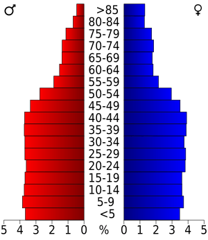
In 2020, the population of Milwaukee County was 939,489. The county is very diverse. Many different groups of people live here.
About 52% of the people were White. Around 26.2% were Black or African American. About 4.9% were Asian, and 0.8% were Native American. About 6.8% were from other races, and 9.3% were from two or more races. People of Hispanic or Latino background made up about 16.3% of the population.
Transportation in Milwaukee County
Getting around Milwaukee County is easy with different transportation options.
Bus and Streetcar Services
The Milwaukee County Transit System provides bus service throughout the county. They have almost 370 buses. The city of Milwaukee also has a streetcar system called The Hop. It runs in the downtown area.
Airports in Milwaukee County
- Milwaukee Mitchell International Airport (KMKE) is the main airport for the whole area. It has flights to many cities in the United States, Canada, and Mexico.
- Lawrence J. Timmerman Airport (KMWC) also serves the county and nearby communities.
Railroads in Milwaukee County
Several train companies operate in Milwaukee County. These include Amtrak, Canadian Pacific Kansas City, Union Pacific, and Wisconsin and Southern Railroad. There are also two main train stations:
- Milwaukee Intermodal Station
- Milwaukee Airport Railroad Station
Major Highways in Milwaukee County
Many important highways run through Milwaukee County, connecting it to other parts of Wisconsin and beyond.
 Interstate 41
 Interstate 43
 Interstate 94
 Interstate 794
 Interstate 894
 U.S. Highway 18
 U.S. Highway 41
 U.S. Highway 45
 Highway 24
 Highway 32
 Highway 36
 Highway 38
 Highway 57
 Highway 59
 Highway 100
 Highway 119
 Highway 145
 Highway 175
 Highway 181
 Highway 190
 Highway 241
 Highway 794
Cities and Villages in Milwaukee County
Milwaukee County has many different communities. These are divided into cities and villages.
Cities in Milwaukee County
- Cudahy
- Franklin
- Glendale
- Greenfield
- Milwaukee (the county seat)
- Oak Creek
- South Milwaukee
- St. Francis
- Wauwatosa
- West Allis
Villages in Milwaukee County
Education in Milwaukee County
Milwaukee County has many school districts. They help educate students from kindergarten all the way through high school.
K-12 School Districts
These districts serve students from kindergarten to 12th grade:
- Brown Deer School District
- Cudahy School District
- Franklin Public School District
- Greendale School District
- Greenfield School District
- Milwaukee School District
- Oak Creek-Franklin School District
- St. Francis School District
- Shorewood School District
- South Milwaukee School District
- Wauwatosa School District
- West Allis School District
- Whitefish Bay School District
- Whitnall School District
High School Districts
- Nicolet Union High School District
Elementary School Districts
These districts focus on younger students:
- Fox Point Joint No. 2 School District
- Glendale-River Hills School District
- Maple Dale-Indian Hill School District
Charter Schools
- Hmong American Peace Academy
See also
 In Spanish: Condado de Milwaukee para niños
 | Roy Wilkins |
 | John Lewis |
 | Linda Carol Brown |


