
San Germán, Puerto Rico facts for kids
Quick facts for kids
San Germán
Municipio Antónomo de San Germán
|
|||
|---|---|---|---|
|
|
|||
|
|||
| Nickname(s):
City Founder of towns (Ciudad Fundadora de Pueblos)
|
|||
| Anthem: "San Germán es mi pueblo querido" | |||

Map of Puerto Rico highlighting San Germán Municipality
|
|||
| Sovereign state | |||
| Commonwealth | |||
| Settled | 1511 1512 (on 2nd site) |
||
| Founded | September 11, 1570 | ||
| Founded by | Juan Ponce de León | ||
| Named for | Germanus of Auxerre | ||
| Barrios | |||
| Government | |||
| • Type | Mayor–council government | ||
| Area | |||
| • Municipality | 54.51 sq mi (141.18 km2) | ||
| • Land | 54.51 sq mi (141.18 km2) | ||
| • Water | 0.0 sq mi (0 km2) | ||
| Elevation | 528 ft (161 m) | ||
| Population
(2020)
|
|||
| • Municipality | 31,879 | ||
| • Rank | 15th in Puerto Rico | ||
| • Density | 584.83/sq mi (225.804/km2) | ||
| • Metro | 136,212 | ||
| • CSA | 251,260 | ||
| Demonym(s) | Sangermeños | ||
| Time zone | UTC−4 (AST) | ||
| ZIP Codes |
00683, 00636
|
||
| Area code(s) | 787/939 | ||
| Major routes | |||
.jpg)


San Germán is a historic town and municipality in the southwestern part of Puerto Rico. It's located in the Sabana Grande Valley, south of Mayagüez and Maricao. To its north are Lajas, to its east are Hormigueros and Cabo Rojo, and to its west is Sabana Grande.
San Germán is divided into eighteen areas called barrios, plus the downtown area known as San Germán Pueblo. It's an important city in the San Germán–Cabo Rojo Metropolitan Statistical Area.
This city is the second oldest in Puerto Rico, right after San Juan. Its historic downtown is so special that it's protected as the San Germán Historic District. Long ago, Puerto Rico was split into two main parts for managing the island: San Juan and San Germán. San Germán covered the entire western half of the island.
Contents
History of San Germán

When the first bishop of Puerto Rico, Alonso Manso, was named in 1511, San Germán had about 50 residents. In the 1500s, San Germán was one of the biggest settlements, along with Coamo and Aguada.
Spanish settlers arrived in San Germán very early in the history of Puerto Rico. The first small settlement was destroyed in 1511 during an uprising by the Taíno people, who were the native people of the island.
In 1512, a new settlement was built by Miguel Díaz in Guayanilla. It was named after Germaine of Foix, who was the second wife of King Fernando II of Spain. It was also named after Saint Germanus of Auxerre. This town faced attacks from French corsairs (pirates) in 1528, 1538, and 1554. A small fort started being built in 1540, but construction stopped in 1546. This was because people started moving further inland to where the city is today.
On May 12, 1571, a Spanish court in Santo Domingo decided that the people from San Germán and another town called Santa María de Guadianilla should combine into one city. This was done because of the constant French attacks. The new city was built on the Santa Marta Hills in 1573. Its official name was Nueva Villa de Salamanca, named after a city in Spain. However, people still called it San Germán el Nuevo (New San Germán), and later, just Villa de San Germán (City of San Germán).
San Germán is also known as the "founder of towns." In 1514, the Spanish Crown divided the island into two main administrative areas. These areas were called the San Juan Partition and the San Germán Partition.
On September 20, 2017, Hurricane Maria brought a lot of rain to San Germán. This caused many landslides in the area.
Geography of San Germán
San Germán is located in the southwest part of Puerto Rico. The town sits in the Sabana Grande valley. This valley is surrounded by the Cordillera Central mountains to the north and the Santa Marta Hills to the south.
Some mountains in San Germán include Alto del Descanso (2,520 feet or 768 meters) and Tetas de Cerro Gordo (2,897 feet or 883 meters). San Germán also has several rivers, such as the Río Caín, Río Duey, Río Rosario, Río Guanajibo, Río Hoconuco, Guamá River, and Rio El Brujo.
Barrios (Neighborhoods)

Like all municipalities in Puerto Rico, San Germán is divided into areas called barrios. The main town area, where you find the municipal buildings, the central square, and the large Catholic church, is called "el pueblo".
Here are the barrios in San Germán:
Sectors (Smaller Areas)
Barrios are further divided into even smaller areas called sectores (sectors). These sectors can have different names like urbanización (urbanization), reparto (development), barriada (neighborhood), or residencial (residential area).
Special Communities
Some communities in Puerto Rico are called Comunidades Especiales de Puerto Rico (Special Communities of Puerto Rico). These are areas where people might face challenges like social exclusion. In San Germán, some of these special communities include Ancones, Comunidad El Retiro, Comunidad Las Quebradas, La Tea, Parcelas Las Carolinas, Parcelas Minillas in Barrio Minillas, Parcelas Sabana Eneas, and Rosario Peñón.
Climate in San Germán
| Month | Jan | Feb | Mar | Apr | May | Jun | Jul | Aug | Sep | Oct | Nov | Dec | Year |
|---|---|---|---|---|---|---|---|---|---|---|---|---|---|
| Record high °C (°F) | 32.8 (91.0) |
33.3 (91.9) |
35 (95) |
35 (95) |
35 (95) |
37.2 (99.0) |
37.2 (99.0) |
36.1 (97.0) |
36.7 (98.1) |
36.1 (97.0) |
36.7 (98.1) |
36.7 (98.1) |
37.2 (99.0) |
| Mean daily maximum °C (°F) | 30.6 (87.1) |
30.6 (87.1) |
31.1 (88.0) |
31.7 (89.1) |
32.2 (90.0) |
32.8 (91.0) |
33.3 (91.9) |
33.3 (91.9) |
32.8 (91.0) |
32.2 (90.0) |
31.7 (89.1) |
31.1 (88.0) |
32.0 (89.5) |
| Daily mean °C (°F) | 23.9 (75.0) |
23.9 (75.0) |
24.4 (75.9) |
25.6 (78.1) |
26.7 (80.1) |
27.2 (81.0) |
27.2 (81.0) |
27.2 (81.0) |
27.2 (81.0) |
26.7 (80.1) |
25.6 (78.1) |
24.4 (75.9) |
25.8 (78.5) |
| Mean daily minimum °C (°F) | 16.7 (62.1) |
16.7 (62.1) |
17.8 (64.0) |
18.9 (66.0) |
20.6 (69.1) |
21.7 (71.1) |
21.1 (70.0) |
21.1 (70.0) |
21.1 (70.0) |
20.6 (69.1) |
19.4 (66.9) |
17.2 (63.0) |
19.4 (67.0) |
| Record low °C (°F) | 6.7 (44.1) |
10.6 (51.1) |
10.0 (50.0) |
10.0 (50.0) |
13.3 (55.9) |
14.4 (57.9) |
11.7 (53.1) |
14.4 (57.9) |
15.6 (60.1) |
13.3 (55.9) |
11.7 (53.1) |
9.4 (48.9) |
6.7 (44.1) |
| Average rainfall mm (inches) | 63.8 (2.51) |
55.6 (2.19) |
55.6 (2.19) |
87.1 (3.43) |
130.6 (5.14) |
68.6 (2.70) |
79.5 (3.13) |
132.8 (5.23) |
157.5 (6.20) |
185.2 (7.29) |
145.0 (5.71) |
59.2 (2.33) |
1,220.5 (48.05) |
| Source: The Weather Channel | |||||||||||||
Tourism in San Germán

San Germán's historic downtown is famous for the Porta Coeli church. This is one of the very first Spanish churches built in the Americas. Porta Coeli is a major historical site that brings in many visitors every year.
Landmarks and Places to Visit

- Puente de Bolas (Bridge of Balls)
- Museo Farmacia La Botica (Pharmacy Museum)
- Museo de la Historia de San Germán (San Germán History Museum)
- Casa Morales
- Ceiba de la Libertad
- San Germán Historic Gallery
- Lola Rodríguez de Tió Museum
- Casa Cruz de la Luna
- Ramírez de Arrellano y Rossell Museum
- Santo Domingo Plazuela
- Three Races and One Culture Mural
- San Germán Historic District
- Porta Coeli
- Inter-American University of Puerto Rico
- Church San Germán de Auxerre
- Russian Orthodox Church Saint John Climacus (the only Russian Orthodox Church in Puerto Rico)
The center of San Germán is mostly made up of Spanish colonial houses. Many of these old houses have been fixed up and still look like they did in Spanish times. There are projects happening to help keep San Germán's historic look.
Culture in San Germán

Festivals and Events
San Germán celebrates its patron saint festival in late July or early August. This festival, called Fiestas Patronales de San German Euserre, is a religious and cultural event. It usually includes parades, games, local crafts, fun rides, regional food, and live shows.
Other fun festivals and events in San Germán include:
- Festival de la Pana – July
- Anón Festival – September
- Christmas Festival – December
- Christmas Parade – Early December
- Patron Celebrations (The Virgin of the Rosary)—Celebrated in San Germán's Rosario Poblado, near Mayagüez.
Sports in San Germán
San Germán is home to one of Puerto Rico's oldest basketball teams, the San Germán Athletics (known as "los Atléticos de San Germán"). They are nicknamed "The Orange Monster." Many famous Puerto Rican basketball players have played in San Germán, which is why the city is called "The Cradle of Puerto Rican Basketball." Some of these players include Arquelio Torres, José "Piculín" Ortiz, and Eddie Casiano. Their home court is The Arquelio Torres Ramírez Court, which can hold about 5,000 fans.
The Athletics' fans are often called their "sixth man" or "The Orange Monster." This is because they are so loud and supportive during games, making it very tough for visiting teams to win in San Germán.
The Athletics have played in 26 National Superior Basketball (BSN) Finals. They have won 14 championships: 1932, 1936, 1939, 1941, 1942, 1943, 1947, 1948, 1949, 1950, 1985, 1991, 1994, and 1997.
Economy of San Germán
Agriculture
In the area around San Germán, farmers grow fruits like bananas and pineapples. Sugarcane is also grown here. There are also small dairy farms. Some local people grow other types of produce on a smaller scale.
Businesses
Most businesses are found in or near the downtown area, San Germán Pueblo. Plaza del Oeste is the main shopping center in the city.
Industry
Some of the big companies that employ people in San Germán include Fresenius Kabi, CCL, Wallace International, Baxter Serum Mfg., Cordis, Insertco (a print shop for medical instructions), Wallace Silversmiths de Puerto Rico, and General Electric (which makes circuit breakers). There are also many companies in the service industry.
Movies Filmed in San Germán
- Act of Valor (2012): This movie follows a Navy Seal team on a secret mission.
- Dinero Sangre (1986): This film is about a mercenary looking for gold.
Population of San Germán
| Historical population | |||
|---|---|---|---|
| Census | Pop. | %± | |
| 1900 | 20,246 | — | |
| 1910 | 22,143 | 9.4% | |
| 1920 | 23,848 | 7.7% | |
| 1930 | 23,768 | −0.3% | |
| 1940 | 26,473 | 11.4% | |
| 1950 | 29,553 | 11.6% | |
| 1960 | 27,667 | −6.4% | |
| 1970 | 27,990 | 1.2% | |
| 1980 | 32,922 | 17.6% | |
| 1990 | 34,962 | 6.2% | |
| 2000 | 37,105 | 6.1% | |
| 2010 | 35,527 | −4.3% | |
| 2020 | 31,879 | −10.3% | |
| U.S. Decennial Census 1899 (shown as 1900) 1910–1930 1930–1950 1960–2000 2010 2020 |
|||
| Ethnicity – (self-defined) San Germán, Puerto Rico – 2010 Census |
||
|---|---|---|
| Ethnicity | Population | % of Total |
| European | 29,614 | 83.4% |
| African | 1,989 | 5.6% |
| Native American and Alaska Native |
129 | 0.4% |
| Asian | 41 | 0.1% |
| Native Hawaiian Pacific Islander |
5 | 0.0% |
| Some other ethnicity | 2,992 | 8.4% |
| Two or more ethnicities | 727 | 2.1% |
Transportation in San Germán
By the 1500s, there was a rough road called Camino de Puerto Rico (Royal Road). This road connected San Germán to other parts of Puerto Rico, including San Sebastián, Arecibo, Toa Alta, and Caparra.
In 2019, there were 44 bridges located in San Germán.
Symbols of San Germán
The municipio (municipality) of San Germán has its own official flag and coat of arms.
Flag of San Germán
- Green represents the importance of the church and is also the color of the shield of Christopher Columbus and his son, Diego Colón. They named the city after Germaine of Foix.
- White shows the purity of the families who first settled San Germán, according to an old history book.
- Purple is the color from the shield of Juan Ponce de León, who was the first governor of Puerto Rico.
Coat of Arms of San Germán
- First Quarter: The bishop's hat (mitre) and staff on a green background represent St. Germain of Auxerre, who is the patron saint of the city.
- Second Quarter: This part shows the symbols of the Kingdoms of Aragón and Sicily, where King Fernando the Catholic ruled.
- Third Quarter: This section combines the symbols of the County of Foix and the Kingdom of France. These are the family symbols of Germaine de Foix, whose name is used for the city of San Germán.
- Fourth Quarter: This part features Juan Ponce de León's shield.
- The Crown: This crown is a symbol for towns and cities. San Germán has five towers on its crown. This shows that the Spanish crown officially gave San Germán the title of "city" in the 1800s.
Education in San Germán
Here are some of the schools in San Germán:
- Bartolome de Las Casas: PK-6
- Georgina Alvarado: PK-5
- Henry W. Longfellow: PK-5
- Herminia C. Ramirez: PK-5
- Julio Victor Guzman: KG-8
- Laura Mercado: 6–12
- Lola Rodriguez de Tio: 9–10
- Mariano Abril: PK-6
- (Second Unit) Francisco Maria Quinones: KG-8
The main campus of the Inter-American University of Puerto Rico is located next to the downtown area of San Germán. It was started in 1912 as the Polytechnical Institute of Puerto Rico. It was the first private university on the island. The Colegio San José was a private school that opened in San Germán in 1930 and closed in 2017.
Famous People from San Germán
- PFC Joseph R. (José) Martínez: During World War II, he bravely destroyed a German infantry unit and tank in Tunisia. He saved his platoon from attack and was awarded the Distinguished Service Cross, which is a very high military honor.
- Ubaldino Ramírez de Arellano: A Senator.
- Lola Rodríguez de Tió: A poet and writer. She wrote the original words for Puerto Rico's national anthem, La Borinqueña. She also supported Puerto Rico's independence.
- Benjamín Marcantoni: An opera singer.
- Benicio del Toro: An award-winning actor.
- Francisco Mariano Quiñones: A politician who worked to end slavery.
- Samuel R. Quiñones: He served as the President of the Puerto Rico Senate for twenty years, which is the longest time anyone has held that position.
Images for kids
-
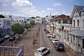
San Germán
-
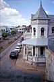
Street in San Germán
-
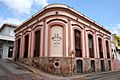
Pharmacy Museum
-
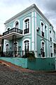
Residential building in San Germán

See also
 In Spanish: San Germán (Puerto Rico) para niños
