
Pelham Bay Park facts for kids
Quick facts for kids Pelham Bay Park |
|
|---|---|

Northern tip of Hunter Island in Pelham Bay Park
|
|
| Type | Municipal |
| Location | The Bronx, New York, US |
| Area | 2,772 acres (1,122 ha) |
| Created | 1888 |
| Operated by | New York City Department of Parks and Recreation |
| Public transit access | Subway: Pelham Bay Park ( MTA New York City Bus: Bx29 Bee-Line Bus: 45 |
Pelham Bay Park is a huge park located in the northeast part of the Bronx, a borough of New York City. It's the biggest public park in New York City, covering about 2,772 acres (1,122 ha). That's more than three times the size of Manhattan's famous Central Park! The New York City Department of Parks and Recreation (NYC Parks) takes care of the park.
Pelham Bay Park is full of interesting natural and man-made spots. You'll find several peninsulas here, like Rodman's Neck and the areas that used to be Hunter and Twin Islands. A calm lagoon flows through the middle, and Eastchester Bay separates one corner of the park. There are also many fun places to visit. Orchard Beach, a popular sandy spot, stretches along the park's eastern side. You can also find two golf courses and lots of nature trails. Other cool places include the historic Bartow-Pell Mansion and the Bronx Victory Column & Memorial Grove.
Before it became a park, this land was part of a settlement founded by Anne Hutchinson. Later, in 1654, an Englishman named Thomas Pell bought a large area from the Siwanoy Native American tribe. This land became known as Pelham Manor. During the American Revolutionary War, the park area was a key battleground. The Battle of Pell's Point happened here, where American soldiers bravely stopped a British advance. The park was officially created in 1888. Orchard Beach, one of the city's most loved beaches, was built in the 1930s thanks to the efforts of Robert Moses, a famous city planner.
A Look Back in Time
Early Days and Native Americans
Long before New York State was settled, Pelham Bay Park was a group of islands separated by salt marshes and beaches. Most of the park's land was formed at the end of the last ice age, about 10,000 to 15,000 years ago. As the glaciers melted, they created the marshes we see today.
The Siwanoy people were the first Native Americans to live along the northern shore of Long Island Sound. They were hunter-gatherers, meaning they found their food by hunting and collecting plants. The Siwanoy used the park area for important ceremonies and burials. Two large rocks, called glacial erratics, were left behind by the glaciers and used by the Siwanoy for their ceremonies.
From Settlements to Battles

In 1639, the Dutch West India Company bought the land and called it Vreedelandt, meaning "land of peace." In 1642, Anne Hutchinson and her family moved to the area. Though they were English, the land was under Dutch rule. Sadly, the Siwanoy attacked their settlement in August 1643.
In 1654, an Englishman named Thomas Pell bought a huge area of land, about 50,000 acres (20,000 ha), from the Siwanoy. This land included what is now Pelham Bay Park. It became known as Pelham Manor.

The park area was the site of the Battle of Pell's Point during the American Revolutionary War. On October 18, 1776, British forces landed nearby. About 750 American soldiers, led by Colonel John Glover, hid behind stone walls and attacked the British. After several fights, the British stopped their advance, and the Americans were able to retreat safely.
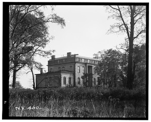
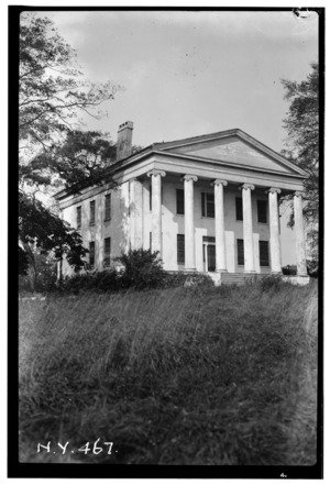
In 1836, Robert Bartow, a descendant of Thomas Pell, bought 30 acres (12 ha) of the old estate. By 1842, the beautiful Bartow-Pell Mansion was built. The city bought the mansion in the 1880s.
Creating the Park
In the 1870s, a famous landscape architect named Frederick Law Olmsted imagined a "greenbelt" of parks and parkways across the Bronx. In 1881, New York Herald editor John Mullaly started pushing for new parks, especially the land that would become Pelham Bay Park.

Even though some people worried about the cost and location, supporters argued that the parks would benefit everyone and increase property values. In June 1884, the New Parks Act was signed into law, allowing the park system to be created.
The city officially acquired the land for Pelham Bay Park in 1887, and it opened as a park in 1888. The Bronx Parks Department bought the land for over $2.7 million. Some of the old mansions from the estates were still standing years later.
Early Park Life and Changes
.jpg)
In 1890, there was a suggestion to use the park for the 1893 World's Fair, but it ended up in Chicago. Pelham Bay Park became part of New York City in 1895 when the eastern part of the Bronx was added to the city. Because the park was far from the city center, NYC Parks decided to keep much of it in its natural state.
By the early 1900s, Hunter Island became a popular summer vacation spot. In 1905, a campsite opened at Rodman's Neck, and Orchard Beach, then a small area, was expanded. However, by the 1920s, the park's condition started to get worse due to heavy use and vandalism.
Robert Moses and Park Upgrades
.jpg)
Robert Moses, a powerful New York City park commissioner, led a big renovation project in the 1930s. He planned a new Orchard Beach and a golf course. The beach and golf course were rebuilt with help from the Works Progress Administration (WPA), a program from the 1930s New Deal.
Moses connected Hunter Island and the Twin Islands to Rodman's Neck by filling in much of LeRoy's Bay. The old Hunter Mansion was taken down to make way for the beach. The golf courses reopened in 1935. The new Orchard Beach was designed by Gilmore David Clarke and Aymar Embury II and officially opened on June 25, 1937. It was expanded over the next few years, with new jetties and a promenade.
In 1959, the New York City Police Department built the Rodman's Neck Firing Range at the southern tip of the peninsula, using part of the parkland.
Cleaning Up and Protecting Nature

In the 1960s, there were plans to expand landfills in Pelham Bay Park. However, many people in the community were against it. Thanks to efforts led by Dr. Theodore Kazimiroff, a Bronx historian, two wildlife refuges were created in 1967: the Thomas Pell Wildlife Sanctuary and the Hunter Island Marine Zoology and Geology Sanctuary. These sanctuaries protected the land where the landfill was planned. The landfill eventually closed in 1978.
In 1983, the Theodore Kazimiroff Environmental Center and a nature trail were proposed in honor of the late historian. The Kazimiroff Nature Trail and the Pelham Bay Park Environmental Center opened in June 1986. Orchard Beach also got a $1 million renovation around this time.
In the 1990s, NYC Parks received money for improvements, which helped renovate trails and clean up the park. A water park was planned for Orchard Beach but was later canceled. For the city's bid for the 2012 Summer Olympics, there were ideas to upgrade facilities in Pelham Bay Park, but London won the bid instead.
More recently, in 2010, work began to extend the jetty at Orchard Beach. A project to restore the park's shoreline, including the seawall and new walking trails, also started. In 2012, ancient Native American shell middens (piles of shells) were found at Tallapoosa Point, leading to archaeological studies that uncovered artifacts dating back to the third century.
Exploring the Park
Pelham Bay Park is the largest park in New York City, with about 13 miles (21 km) of shoreline. It has land on both sides of the Hutchinson River. Places like Hunter Island, Twin Island, and Two-Trees Island used to be real islands. Now, they are connected to the mainland by land that was filled in. The park also includes several islands in the Long Island Sound and Goose Island in the Hutchinson River.
The park has many different natural areas. The largest parts are its forests, followed by salt marshes, salt flats, and meadows. About 67% of the park is still in its natural state.
Interesting Land Features
Hunter Island's Story
Hunter Island is a 166-acre (67 ha) peninsula covered in woodlands. It was once a true island. The Siwanoy people called it "Laap-Ha-Wach King," meaning "place of stringing beads." The island was later named after John Hunter, who bought the land in 1804. He built a large mansion there, which was taken down in 1937 when Orchard Beach was built. In 1967, the island became part of the Hunter Island Wildlife Sanctuary.
Twin Island's Natural Beauty
Twin Island is a wooded area with exposed bedrock and marks left by glaciers. The East and West Twin Islands were once separate islands but are now connected to each other and to Orchard Beach by land filled in during 1937. East Twin Island has colorful rocks from erosion. West Twin Island was once connected to Hunter Island by a stone bridge, which is now in ruins in a salt marsh.
Twin Island has been part of Pelham Bay Park since 1888. A tennis court was built there in 1899. In 1995, Twin Island was restored as part of a $850,000 project.
Rodman's Neck
Rodman's Neck is a peninsula in the middle of the park. The southern part is used as a firing range by the New York City Police Department (NYPD). The rest of the wooded area is part of Pelham Bay Park. The north side has several baseball fields.
Rodman's Neck was part of Thomas Pell's historic property. Since the city bought it in 1888, it has been used for many things. It was a training spot for the United States Army during World War I and a summer camp for the NYPD in the 1930s.
Tallapoosa Point
Tallapoosa Point is in the southwest part of Pelham Bay Park. It used to be a separate island but was connected to the mainland long ago. It became a popular spot for fishing. In 1879, a political group called the Tallapoosa Club leased part of the peninsula, giving it its current name.
From 1963 to 1968, Tallapoosa Point was used as a dump. After that, it became part of the Wildlife Refuge. Today, it has been replanted and is an important habitat for birds.
Waterways to Explore
Pelham Bay
Between City Island and Orchard Beach is a body of water called Pelham Bay. It connects to Eastchester Bay and opens onto Long Island Sound. About one-third of the original bay was filled in to create Orchard Beach between 1934 and 1938.
Eastchester Bay
Eastchester Bay separates City Island and most of the park from the park's southwest part. The Pelham Bridge crosses it, connecting the two sections of the park. The Hutchinson River flows into Eastchester Bay.
The Lagoon
A lagoon in the park was once part of Pelham Bay and was called LeRoy's Bay. It used to separate Hunter and Twin Islands from the mainland. It was a popular place for rowing races.
Most of the lagoon was filled in during the 1930s when Orchard Beach was rebuilt. It became known as the "Orchard Beach Lagoon." In 1964, the lagoon was chosen for the 1964 Summer Olympics rowing trials. It was widened and deepened to become a 2,000-meter (6,600 ft) rowing track. After the Olympics, many colleges used the lagoon for rowing practice.
Turtle Cove
Turtle Cove is a small cove along the north side of City Island Road. Around the early 1900s, a land barrier was built across Turtle Cove for horsecar rails. This made the north end of the cove mostly freshwater, which attracted rare birds.
In 2009, NYC Parks started a project to restore the cove. They removed the old barrier and dug a canal to let salt water flow in. They also planted 10,000 trees to restore 11 acres (4.5 ha) of forest. The cove also has a batting cage and a golf center with miniature golf.
Special Natural Features
Glover's Rock

Glover's Rock is a giant granite rock left behind by glaciers. It has a bronze plaque remembering the Battle of Pell's Point. While the rock itself wasn't directly involved in the battle, it's named after Colonel John Glover, who led the American soldiers.
Split Rock

Split Rock is a large, dome-shaped granite boulder located near the intersection of the New England Thruway and Hutchinson River Parkway. It's about 25 feet (7.6 m) long and 15 feet (4.6 m) wide. This huge rock broke in half about 10,000 years ago due to glacial movements.
Split Rock is also near the spot where Anne Hutchinson and her family were attacked by Native Americans in 1643. In 1911, a bronze plaque was placed on the rock to honor Anne Hutchinson, but it was stolen in 1914. The plaque read:
ANNE HUTCHINSON
Banished from the Massachusetts Bay Colony in 1638
Because of her Devotion to Religious Liberty This Courageous Woman
Sought Freedom from Persecution in New Netherland
Near this Rock in 1643 She and her Household
were Massacred by Indians
This Tablet is placed here by the Colonial Dames of the State of New York
ANNO DOMINI MCMXI Virtutes Majorum Filiae Conservant
In the 1950s, Theodore Kazimiroff helped save Split Rock from being destroyed when Interstate 95 was being built.
Treaty Oak
Treaty Oak is located near the Bartow-Pell Mansion. A treaty was reportedly signed under this oak tree in 1654 between Siwanoy Chief Wampage and colonist Thomas Pell. The original tree was destroyed by lightning in 1906 and toppled in a storm in 1909. A new tree, an elm, was planted in its place in 1915.
Wildlife Sanctuaries
The Thomas Pell Wildlife Sanctuary and the Hunter Island Marine Zoology and Geology Sanctuary cover 489 acres (1.98 km2) of marshes and forests within Pelham Bay Park. They were created in 1967 to protect the land. Many of the forests in these sanctuaries are very old, dating back hundreds of years. The park also has two nature centers.
Thomas Pell Wildlife Sanctuary
The Thomas Pell Wildlife Sanctuary is in the western part of Pelham Bay Park. It includes Goose Creek Marsh, which was once part of a huge wetland, and saltwater wetlands along the Hutchinson River. The sanctuary is home to many animals like raccoons, egrets, hawks, and coyotes.
Hunter Island Marine Zoology and Geology Sanctuary
Located north of Orchard Beach, the Hunter Island Marine Zoology and Geology Sanctuary includes Twin Islands, Cat Briar Island, Two Trees Island, and the northeastern shore of Hunter Island. It has many large boulders left by glaciers and the biggest continuous oak forest in Pelham Bay Park. This sanctuary has a special marine ecosystem that is rare in New York State.
Wildlife Activities

The park is a great place for bird watching, with up to 264 different species spotted! You can see great horned owls, red-tailed hawks, and many kinds of warblers on Hunter Island. In the meadows, you might spot American woodcocks and woodpeckers. Birds like loons and gulls can be seen along the coasts and in the bays. Pelham Bay Park is located along a major path for seasonal bird migration. The National Audubon Society has even named it an "Important Bird Area."
Saltwater fishing is also popular in the park, but it's not allowed on Orchard Beach when the beach is open in the summer. There are two main areas where you can fish: in the southern part of the park near Eastchester Bay and in the northern part near the Lagoon and Turtle Cove.
Landmarks and Fun Spots
Orchard Beach

Orchard Beach is the only public beach in the Bronx. It's 1.1-mile-long (1.8 km) and shaped like a crescent, facing the Long Island Sound. Orchard Beach is sometimes called the "Bronx Riviera" or the "Working Class Riviera." It has two twin pavilions, which were named city landmarks in 2006.
Bronx Victory Column & Memorial Grove

The Bronx Victory Column & Memorial Grove is a 70-foot-tall (21 m) limestone column with a bronze statue of Winged Victory. It's located on Crimi Road in the park. The trees around the statue were first planted in 1921 to honor Bronx servicemen. The monument was designed by John J. Sheridan and sculpted by Belle Kinney and Leopold Scholz. It was dedicated on September 24, 1933, to honor the 947 Bronx residents who died in World War I. The statue is 18 feet tall and weighs 3,700 pounds (1,700 kg). It's a popular spot for wedding photography.
Bartow-Pell Mansion
The Bartow–Pell Mansion is a beautiful 19th-century mansion built in the Greek Revival style. It was built in 1842 and sold to the city in 1880. Since 1975, it has been a National Historic Landmark.
Pelham Bay and Split Rock Golf Courses
The Pelham Bay Golf Course opened in 1901, and the Split Rock Golf Course opened in 1935. Both courses have eighteen holes and share an Art Deco clubhouse. The courses are separated by the Northeast Corridor railroad tracks.
Plans for a golf course in Pelham Bay Park started soon after the park was created. In 1899, the New York Athletic Club asked architect Lawrence Van Etten to design an 18-hole course. Construction began in 1900, and the Pelham Bay Golf Course opened in 1901.

In 1934, a new 18-hole course was announced for the north side of the park, along with renovations to the Pelham Bay course. This was part of a city program to upgrade or build ten golf courses. The new Split Rock course and the rebuilt Pelham Bay course opened in 1935. They also built a new two-story clubhouse with a golf store, cafeteria, and lockers.
Bronx Equestrian Center
The northern part of Pelham Bay Park is home to the Bronx Equestrian Center on Shore Road. Here, visitors can ride horses and ponies on the park's trails or take riding lessons. The center also offers wagon rides and hosts special events.
Southwestern Section
The southwestern part of Pelham Bay Park has several fun recreational facilities. The biggest is the Aileen B. Ryan Recreational Complex, which has a running track, two baseball fields, and the Playground for All Children, designed for kids with physical disabilities. Another playground, Sweetgum Playground, is nearby. This section also has a dog run, four more baseball fields, two bocce courts, several basketball courts, and nine tennis courts. The Pelham Bay Nature Center is also located here.
A long, narrow woodland called Huntington Woods is on the southern border of this section. It's named after its last owners, Archer Milton Huntington and his wife, Anna Hyatt Huntington. The city added their land to the park in 1925 and 1933.
This part of the park also has two monuments. American Boy is a sculpture from 1923 that celebrates the athletic body. The other is the Bronx Victory Column & Memorial Grove.
Getting Around the Park
Bridges

When the city acquired Pelham Bay Park in 1888, NYC Parks became responsible for maintaining the western end of the City Island Bridge. This bridge was built in the 1870s and was replaced with a new one in 1901. The century-old City Island Bridge was replaced again in 2015.
The Pelham Bridge, which opened in 1871, was also included in the park. A new stone bridge was built in 1908 to handle more traffic.
Roads
The park is crossed by the Hutchinson River Parkway on its west side and a part of the New England Thruway (I-95) in its northwest corner. An exit from the Hutchinson River Parkway leads directly to the park, Orchard Beach, and City Island.
NYC Parks took over responsibility for the park's roads in 1888 and slowly paved and expanded them. The Hutchinson River Parkway in Pelham Bay Park replaced the old Split Rock Road. It was designed with gentle curves and stone bridges. The parkway is named after Anne Hutchinson and her family. The modern parkway was extended through Pelham Bay Park in December 1937. The New England Thruway opened in October 1958.
Public Transport

You can reach Pelham Bay Park by the New York City Subway at its station, Pelham Bay Park, on the west side of the Bruckner Expressway. The station opened in December 1920. A pedestrian bridge from the station crosses the expressway and leads right into the park.
The MTA Regional Bus Operations' Bx29 route and Bee-Line Bus System's 45 route also stop at the park. The Bx12 bus serves Orchard Beach only during the summer.
Railroads
The Harlem River and Port Chester Railroad opened in 1873, with some parts running through what is now the park. This railroad was a branch of the New Haven Line. One of its stations, called City Island or Bartow, was located in the park area. Today, Amtrak owns these tracks as part of its Northeast Corridor. The old Bartow station house still exists, but it's in ruins.
A railroad also connected City Island and Pelham Bay Park from 1887 to 1919. It was a narrow-gauge horsecar route. Later, a monorail was built, but it had problems and stopped running in 1914.
Paths
Bicycle paths connect all parts of the park and extend to other areas like Bronx Park and City Island. The bike trails within the park have different difficulty levels.
Scenic Trails
The Kazimiroff Nature Trail, which opened in 1986, is a great place to observe wildlife. It covers 189 acres (76 ha) of Hunter Island.
The Siwanoy Trail is a system of trails that starts in the Central Woodlands section of the park. It leads to different areas like the Rodman's Neck meadow and the Bartow-Pell Mansion.
The Split Rock Trail is 1.5 miles (2.4 km) long and runs along the west side of the park. It was first created in 1938 and was renovated in 1987.
The park also has a bridle path, which is a trail for horses. It goes around both golf courses and has a path to the Bronx Equestrian Center.
