Waukesha County, Wisconsin facts for kids
Quick facts for kids
Waukesha County, Wisconsin
|
|||
|---|---|---|---|

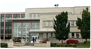
Waukesha County Courthouse
|
|||
|
|||
| Motto(s):
"Leading the way!"
|
|||

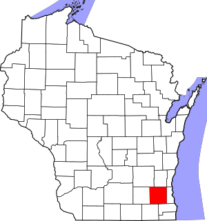
Map of Wisconsin showing Waukesha County
|
|||

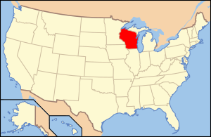
Wisconsin's location in the contiguous United States
|
|||
| Country | |||
| State | |||
| Incorporated | 1846 | ||
| County seat | Waukesha | ||
| Largest city | Waukesha | ||
| Area | |||
| • Total | 581 sq mi (1,500 km2) | ||
| • Land | 550 sq mi (1,400 km2) | ||
| • Water | 31 sq mi (80 km2) | ||
| Population
(2020)
|
|||
| • Total | 406,978 | ||
| • Estimate
(2023)
|
412,591 |
||
| • Rank | 3rd largest county in Wisconsin | ||
| • Density | 740.3/sq mi (285.8/km2) | ||
| Time zone | UTC−6 (Central) | ||
| • Summer (DST) | UTC−5 (Central) | ||
| Area codes | 262, 414 | ||
| Congressional districts | 5th | ||
| Interstates | |||
| U.S. Routes | |||
| State Routes | |||
| Airports | Waukesha County Airport Capitol Airport | ||
Waukesha County is a county in the state of Wisconsin, USA. It is pronounced "WAW-kuh-shaw". In 2020, about 406,978 people lived here. This makes it the third-largest county in Wisconsin by population.
Waukesha County is known for having a high average income. In 2020, it was one of the top 100 counties in the U.S. for median income. The main city and county seat is Waukesha. The county is part of the larger Milwaukee–Waukesha–West Allis metropolitan area.
Contents
History of Waukesha County
Early Days and Native American Tribes
Long ago, the land that is now Waukesha County was covered in forests and prairies. Many Native American tribes lived here, including the Menomonie, Ojibwe (Chippewa), Potawatomi, and Ho-Chunk (Winnebago). They farmed the land and traded goods with each other.
In 1836, these tribes lost their rights to the land. Treaties were ignored, and the U.S. Army forced them to leave. Before the 1830s, few settlers lived here because it was inland. The Fox River was not a major travel route for boats.
First Settlers and County Formation
The first European settlers came from New England. They set up trading posts between their new camps and bigger cities like Milwaukee. Morris D. Cutler and Alonso Cutler were the first permanent white settlers. They came to claim land for their homes.
The area was first part of Michigan Territory and then Wisconsin Territory. In January 1846, Waukesha County was officially created from part of Milwaukee County. Curtis Reed was the first leader of the county. When it was time to choose a county seat, Waukesha won by just two votes over Pewaukee.
The name "Waukesha" comes from a Potawatomi word meaning 'fox'. This is because the streams in the southern part of the county flow into the Fox River.
New England Influence
Many of Waukesha's first settlers were "Yankees" from New England. They came from places like Connecticut, Massachusetts, Vermont, New Hampshire, and Maine. Others came from upstate New York, whose parents had moved there from New England. These people were descendants of the English Puritans who settled New England in the 1600s.
They moved west into the Northwest Territory in the early 1800s. Many arrived after the Erie Canal was finished and the Black Hawk War ended. These New Englanders built farms, roads, and government buildings. They also set up mail routes.
They brought their values with them, like a strong belief in education. This led to many schools being built. They also strongly supported ending slavery. Most were members of the Congregationalist Church. Some later became Methodists or Baptists. For a long time, Waukesha kept a lot of its early New England culture. Later, many German immigrants moved to Wisconsin in the late 1800s.
In 2024, a very old sea creature called a trilobite was named Waukeshaaspis after the county.
Geography and Nature
Waukesha County covers about 581 square miles. Most of this is land (550 square miles), and about 31 square miles (5.3%) is water. The Fox River flows through the county.
The county is located west of Milwaukee. The building of Interstate 94 in Wisconsin helped the area grow with many new neighborhoods and towns.
Lake Country Fun
The northwestern part of Waukesha County is often called "Lake Country." This is because it has many beautiful lakes! Some of the towns and villages in this area include Pewaukee, Delafield, Hartland, Oconomowoc, and Lac La Belle. It's a great place for water activities.
Neighboring Counties
Waukesha County shares borders with several other counties:
- Washington County to the north
- Ozaukee County to the northeast
- Milwaukee County to the east
- Racine County to the southeast
- Walworth County to the southwest
- Jefferson County to the west
- Dodge County to the northwest
Climate
|
||||||||||||||||||||||||||||||||||||||||||||||||||||||||||||||||||||||||||||||||||||||||||||||||
Waukesha County experiences a typical Midwest climate. This means it has warm summers and cold, snowy winters. The chart shows the average high and low temperatures in Celsius and the average rainfall in millimeters for each month.
Population and People
| Historical population | |||
|---|---|---|---|
| Census | Pop. | %± | |
| 1850 | 19,258 | — | |
| 1860 | 26,831 | 39.3% | |
| 1870 | 28,274 | 5.4% | |
| 1880 | 28,957 | 2.4% | |
| 1890 | 33,270 | 14.9% | |
| 1900 | 35,229 | 5.9% | |
| 1910 | 37,100 | 5.3% | |
| 1920 | 42,612 | 14.9% | |
| 1930 | 52,358 | 22.9% | |
| 1940 | 62,744 | 19.8% | |
| 1950 | 85,901 | 36.9% | |
| 1960 | 158,249 | 84.2% | |
| 1970 | 231,365 | 46.2% | |
| 1980 | 280,326 | 21.2% | |
| 1990 | 304,715 | 8.7% | |
| 2000 | 360,767 | 18.4% | |
| 2010 | 389,891 | 8.1% | |
| 2020 | 406,978 | 4.4% | |
| U.S. Decennial Census 1790–1960 1900–1990 1990–2000 2010–2020 |
|||
How Many People Live Here?
The population of Waukesha County has grown a lot over the years. In 1850, there were about 19,258 people. By 2020, the population had grown to 406,978! This shows how much the area has developed.
Who Lives in Waukesha County?
According to the 2020 census, most people in Waukesha County are White (87%). There are also people of Asian (3.9%), Black or African American (1.7%), and Native American (0.3%) backgrounds. About 5.7% of people identify with two or more races. About 5.4% of the population is Hispanic or Latino.
The average age of people in Waukesha County in 2010 was 42 years old. About 24.1% of the population was under 18 years old.
Communities in Waukesha County
Waukesha County is home to many different cities, villages, and towns.
Cities
- Brookfield
- Delafield
- Milwaukee (a small part is in Waukesha County)
- Muskego
- New Berlin
- Oconomowoc
- Pewaukee
- Waukesha (the county seat)
Villages
Towns
Other Places to Know
- Census-designated places: These are areas that are like towns but are not officially incorporated.
- North Lake
- Okauchee Lake
- Unincorporated communities: These are smaller communities that are not part of a city or village.
- Ghost towns/neighborhoods: These are places that used to be communities but are no longer active.
- Calhoun
- Dodges Corners
- DeNoon
- Duplainville
- Muskego Settlement
- New Upsala
Education in Waukesha County
Waukesha County has many school districts that serve students from kindergarten through high school.
School Districts (K-12)
- Elmbrook School District
- Hamilton School District
- Kettle Moraine School District
- Menomonee Falls School District
- Mukwonago School District
- Muskego-Norway School District
- New Berlin School District
- Norris School District
- Oconomowoc Area School District
- Palmyra-Eagle Area School District
- Pewaukee School District
- Waukesha School District
- West Allis School District
High School Districts (Secondary)
- Arrowhead Union High School District
- Waterford Union High School District
Elementary School Districts
- Hartland-Lakeside Joint No. 3 School District
- Lake Country School District
- Merton Community School District
- North Lake School District
- Richmond School District
- Stone Bank School District
- Swallow School District
- Washington-Caldwell School District
Transportation and Travel
Waukesha County has different ways to get around, from trains to buses.
Railroads
Several railroad companies operate in Waukesha County:
- Canadian National
- Canadian Pacific
- Union Pacific
- Wisconsin and Southern Railroad
Buses
- Waukesha Metro Transit provides bus services for people traveling within the county.
See also
 In Spanish: Condado de Waukesha para niños
 | Frances Mary Albrier |
 | Whitney Young |
 | Muhammad Ali |


