Wayne County, Ohio facts for kids
Quick facts for kids
Wayne County
|
|||
|---|---|---|---|

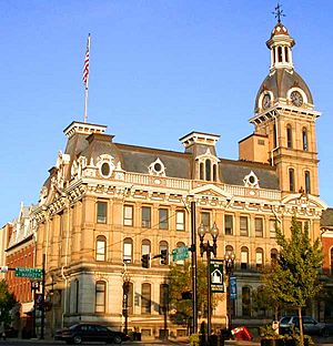
The Wayne County Courthouse in September 2004
|
|||
|
|||

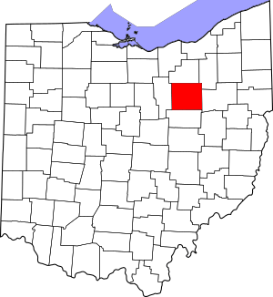
Location within the U.S. state of Ohio
|
|||
 Ohio's location within the U.S. |
|||
| Country | |||
| State | |||
| Founded | January 4, 1812 (date organized; formed 1808) | ||
| Named for | General Anthony Wayne | ||
| Seat | Wooster | ||
| Largest city | Wooster | ||
| Area | |||
| • Total | 557 sq mi (1,440 km2) | ||
| • Land | 555 sq mi (1,440 km2) | ||
| • Water | 1.9 sq mi (5 km2) 0.3%% | ||
| Population
(2020)
|
|||
| • Total | 116,894 | ||
| • Estimate
(2022)
|
116,559 |
||
| • Density | 209.86/sq mi (81.03/km2) | ||
| Time zone | UTC−5 (Eastern) | ||
| • Summer (DST) | UTC−4 (EDT) | ||
| Congressional district | 7th | ||
Wayne County is a place in Ohio, a state in the United States. It's a type of area called a county. In 2020, about 116,894 people lived here. The main town, or county seat, is Wooster.
The county got its name from a famous general named "Mad" Anthony Wayne. Wayne County is also part of the Wooster, OH Micropolitan Statistical Area. This means it's a smaller city area with close ties to Wooster.
Contents
History of Wayne County
Wayne County as we know it today was planned in 1808. It officially started on March 1, 1812.
Before this, there was an older Wayne County. It was created in 1796 by the government of the Northwest Territory. This older county covered a large part of northern Ohio and all of Michigan's lower peninsula. That original Wayne County is now part of Michigan.
Geography and Location
According to the U.S. Census Bureau, Wayne County covers about 557 square miles. Most of this (555 square miles) is land. About 1.9 square miles (0.3%) is water.
Counties Nearby
Wayne County shares its borders with these other counties:
- Medina County (to the north)
- Summit County (to the northeast)
- Stark County (to the east)
- Holmes County (to the south)
- Ashland County (to the west)
People of Wayne County
| Historical population | |||
|---|---|---|---|
| Census | Pop. | %± | |
| 1820 | 11,933 | — | |
| 1830 | 23,333 | 95.5% | |
| 1840 | 35,808 | 53.5% | |
| 1850 | 32,981 | −7.9% | |
| 1860 | 32,483 | −1.5% | |
| 1870 | 35,116 | 8.1% | |
| 1880 | 40,076 | 14.1% | |
| 1890 | 39,005 | −2.7% | |
| 1900 | 37,870 | −2.9% | |
| 1910 | 38,058 | 0.5% | |
| 1920 | 41,346 | 8.6% | |
| 1930 | 47,024 | 13.7% | |
| 1940 | 50,520 | 7.4% | |
| 1950 | 58,716 | 16.2% | |
| 1960 | 75,497 | 28.6% | |
| 1970 | 87,123 | 15.4% | |
| 1980 | 97,408 | 11.8% | |
| 1990 | 101,461 | 4.2% | |
| 2000 | 111,564 | 10.0% | |
| 2010 | 114,520 | 2.6% | |
| 2020 | 116,894 | 2.1% | |
| 2022 (est.) | 116,559 | 1.8% | |
| U.S. Decennial Census 1790-1960 1900-1990 1990-2000 2020 |
|||
In 2010, there were 114,520 people living in Wayne County. There were 42,638 homes and 30,070 families. The county had about 206 people per square mile.
Most people (95.7%) were white. About 1.5% were black or African American. About 0.8% were Asian, and 0.2% were American Indian. People of Hispanic or Latino background made up 1.6% of the population.
The average age in the county was 38.3 years old. The average income for a family was $59,692. About 9.9% of all people in the county lived below the poverty line. This included 14.9% of those under 18.
Family Backgrounds
Many people in Wayne County have family roots from different places.
- Many early settlers came from New England between the 1790s and 1820s. These families were mostly of English ancestry.
- Later, many German immigrants moved to Wayne County. This happened a lot between the 1820s and 1880s.
- In the 1850s, a large group of Irish immigrants arrived.
Today, many people say they have "American" ancestry. This often means their families have been in the United States for a very long time. Many of these families originally came from England. German-Americans have been the largest single group in Wayne County since the late 1800s.
Education in Wayne County
- Central Christian High School
- Chippewa High School
- Dalton High School
- Kingsway Christian School
- Northwestern High School
- Norwayne High School
- Orrville High School
- Rittman High School
- Smithville High School
- Triway High School
- Waynedale High School
- Wooster High School
Communities in Wayne County
Cities
- Orrville
- Rittman
- Wooster (This is the county seat, the main town)
- Norton (Most of this city is in Summit County)
Villages
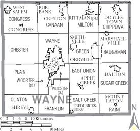
Townships
- Baughman
- Canaan
- Chester
- Chippewa
- Clinton
- Congress
- East Union
- Franklin
- Green
- Milton
- Paint
- Plain
- Salt Creek
- Sugar Creek
- Wayne
- Wooster
Census-designated places
These are areas that are like towns but are not officially incorporated as cities or villages:
Unincorporated communities
These are smaller places that are not officially part of a city or village:
See also
 In Spanish: Condado de Wayne (Ohio) para niños


