
Zutphen facts for kids
Quick facts for kids
Zutphen
|
|||
|---|---|---|---|
|
City and municipality
|
|||

St Walpurga's Church in Zutphen
|
|||
|
|||
.svg)
Location in Gelderland
|
|||

Zutphen
Location in Netherlands

Zutphen
Location in Europe
|
|||
| Country | Netherlands | ||
| Province | Gelderland | ||
| Government | |||
| • Body | Municipal council | ||
| Area | |||
| • Total | 42.93 km2 (16.58 sq mi) | ||
| • Land | 40.98 km2 (15.82 sq mi) | ||
| • Water | 1.95 km2 (0.75 sq mi) | ||
| Elevation | 10 m (30 ft) | ||
| Population
(May 2014)
|
|||
| • Total | 47,052 | ||
| • Density | 1,148/km2 (2,970/sq mi) | ||
| Demonym(s) | Zutphenaar | ||
| Time zone | UTC+1 (CET) | ||
| • Summer (DST) | UTC+2 (CEST) | ||
| Postcode |
7200–7207, 7230–7232
|
||
| Area code | 0575 | ||


Zutphen (Dutch pronunciation: [ˈzʏtfə(n)]) is a city and municipality in the Gelderland province of the Netherlands. It is about 30 kilometers northeast of Arnhem. The city sits on the eastern bank of the IJssel river, where it meets the Berkel river. The name "Zutphen" likely means "south fen" in old Dutch. In 2005, Zutphen joined with the nearby municipality of Warnsveld. In 2021, about 47,052 people lived in Zutphen.
Contents
History of Zutphen


Early Settlements and Viking Raids
Around 300 AD, a Germanic group built the first lasting settlement in Zutphen. This was on low sand dunes near the river. While many such places were left empty in the early Middle Ages, Zutphen stayed. This was because it was in a good spot where the IJssel and Berkel rivers met.
After the area became part of Charlemagne's empire, Zutphen became an important local center. It was ruled by the Count of Zutphen. In 882, Normans attacked and destroyed the town. After this, a round fort was built to protect the growing town from Viking attacks.
Royal Residence and Town Rights
In the 11th century, Zutphen was a royal home for several years. A royal palace, called a pfalz, was built there. A large church, the first St. Walburgis church, was also built. The counts of Zutphen became very powerful. But their family line ended in the 12th century. The last heiress, Ermengarde of Zutphen, married the count of Guelders. Her son, Henry I, Count of Guelders, was the first to hold both titles.
Zutphen received its town rights between 1191 and 1196. This meant the town could govern itself and have its own court. Zutphen was one of the oldest towns in the Netherlands to get these rights. Only Utrecht and Deventer got them earlier. Zutphen then became a "mother town" for other cities in Guelders. These included Arnhem, Doetinchem, Doesburg, Lochem, Harderwijk, Venlo, and Emmerich. Zutphen also joined the Hanseatic League. This was a group of wealthy trading towns that were very important for trade in that part of Europe.
Coin Making and Famous Library
During the 12th century, the Counts of Guelders and Zutphen made coins in Zutphen. The city had the right to make coins for a few centuries. However, it only actively used this right during four short periods.
The biggest and oldest church in Zutphen is the St. Walburgis Church. It was first built in the 11th century. The church you see today is a Gothic building. It holds old monuments, a large copper font from 1527, and a candelabrum from the 14th century.
The church's library, called the Librije, is very special. It has a collection of books from before the Protestant Reformation. Some of these are very valuable manuscripts and early printed books. It is one of only five medieval libraries left in Europe where the books are still chained to their wooden desks. This was a common practice long ago to stop books from being stolen from public libraries.
Wars and Modern Times
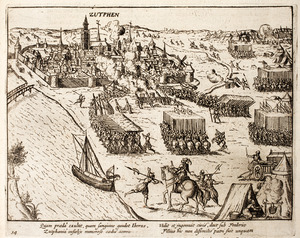
Because Zutphen had strong defenses, it survived many attacks. This was especially true during the Eighty Years' War. A famous battle happened outside its walls in September 1586, where Sir Philip Sidney was badly hurt. The Spanish took Zutphen in 1587. But Maurice, Prince of Orange, took it back in 1591. Since then, Zutphen has mostly been part of the Netherlands. Its defenses were taken down in 1874.
During World War II, the city was bombed several times by Allied forces. This was because the bridge over the IJssel river was important for German troops. After two weeks of fighting, Zutphen was freed on April 14, 1945. After the war, the city was rebuilt. Today, Zutphen has one of the best-preserved medieval town centers in northwestern Europe. It still has parts of its old town wall and hundreds of buildings from the 13th, 14th, and 15th centuries.
Zutphen Today


Zutphen's old city center mostly survived World War II. However, some areas, like around the railway station, were damaged. The city center has many old buildings from the 14th and 15th centuries. Some even date back to the 13th century. You can also still see parts of the old town walls.
Today, Zutphen is a modern small city. The city area, including the village of Warnsveld, has about 51,000 people. Shops are usually open from morning until evening. On Friday evenings, some stores stay open later.
Culture and Architecture
The Tower City
Zutphen is often called the "tower city" because it has many historic buildings with tall towers. There are almost no modern tall buildings in the city center. This means the old tower spires stand out and form the city's skyline. This nickname is often used to attract tourists.
Religious Buildings
- St Walburgis' Church: This church was first built around 1050. It was rebuilt into a Romano-Gothic basilica between 1200 and 1270. Later, more parts were added in the 14th century. After a fire in 1446, the stone tower was rebuilt. It once reached 107.5 meters high! But after a lightning strike in 1600, it was damaged. The current tower is 76 meters tall. Six bells in the tower are still rung by hand. Since 1561, the famous Librije library has been part of the church. It was a public library for wealthy citizens. It has an important collection of books from the 15th to 17th centuries.
- Broederen Church: This is a large church from the early 14th century. It used to be a monastery church for the Dominican Order. Since 1983, it has been the city's public library. It has been carefully restored. A small tower on top has a bell that used to signal when the city gates would close. This bell is still rung every day.
- Nieuwstadt Church: This church is used by the Catholic community. It started as a parish church around 1250. It has been changed and restored many times over the years. It still has four original medieval bells.
City Buildings
- Drogenaps Tower: This tower was built between 1444 and 1446 as a city gate. In 1465, the entrance was closed off, and it became just a tower. A city musician named Tonis Drogenap lived there around 1555, and the tower is named after him. For a while, it was even used as a water tower.
- Wijnhuis Tower: This tower was built between 1618 and 1642. In 1644, two brothers, Pieter and François Hemony, made the world's first perfectly tuned carillon for this tower. A carillon is a musical instrument with many bells. You can still hear carillon concerts there in the summer.
- Bourgonje Tower: This was a defensive tower built in 1457. It was built during a war between Gelderland and Burgundy. A Dutch thinker named Johannes Florentius Martinet wrote one of his famous books in this tower.
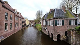
- Berkel Gate: This gate is part of the city wall on the east side of the old city. It crosses the Berkel river and connected the old and new parts of the city. It was built in 1320. There was another gate on the west side, but it was taken down in 1772.
Other Interesting Sights
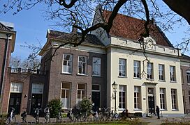
Zutphen has almost 400 national monuments and over 500 local monuments. It is one of the most important and well-preserved historic city centers in the Netherlands. Many houses from the 14th century, with fancy fronts, can be seen all over the city center. There are also large buildings from the 18th and 19th centuries near the old market. These used to belong to rich citizens and merchants.
Zutphen: A Regional Hub
A Center for Law
Even though Zutphen is a relatively small city, it is important for Dutch legal institutions. Zutphen has one of the 13 Dutch courts. It also has the national training center for judges and public lawyers. The national police academy for senior police officers is here too. Zutphen also has several prisons and many lawyers. Zutphen's early importance in the Middle Ages helped it become a key place for the legal system.
Healthcare in Zutphen
Zutphen is home to the "Spittal," which is part of the Gelre Ziekenhuizen group. This hospital offers many common medical services. It also has an emergency department open 24/7. It is located in the southeastern part of the town.
Schools in Zutphen
Zutphen has several well-known schools for secondary education (middle and high school). These include "Het Stedelijk," "Baudartius College," "Vrije School Zutphen" (a Waldorf School), and "Isendoorn College." Students from a wide area around Zutphen come to these schools.
Getting Around Zutphen

By Train
Zutphen railway station is a key train hub for the region. Main electric lines go north to Deventer and Zwolle. South, they go to Arnhem and Nijmegen. These are run by the national railway company, Nederlandse Spoorwegen (NS). Other lines to Winterswijk and Apeldoorn are run by Arriva. The line to Hengelo is run by Blauwnet. These other lines use diesel trains. Zutphen's old station building was damaged in World War II. A new, modern station was built in the 1950s. In 2007, this station was named a State Monument. The area around the station was also updated. A new bus station and an underground bike parking lot were built. The main road to the town center became a path for walkers and cyclists only.
By Road
Zutphen is about 10 kilometers south of the A1 motorway. You can get on the A1 near Deventer. From there, the A1 goes east to Hengelo and west past Apeldoorn to Amsterdam. Other main roads connect Zutphen to places like Arnhem, Doetinchem, Winterswijk, Lochem, and Almen.
By Bus
Most buses in and around Zutphen are run by Arriva. There are three city bus lines. Regional lines go to Doetinchem, Deventer, Almen-Laren, and Vorden. Some bus lines that used to go to Apeldoorn and Dieren have been stopped. Now, you can only reach those towns by car or train.
Sister Cities
Zutphen is connected with these cities around the world:
Leaders from these cities visit each other. There are also programs to help cities like Satu Mare and Villa Sandino develop.
Notable Residents


Public Service
- Gerard Zerbolt of Zutphen (1367–1398) – A writer and early member of the Brethren of the Common Life.
- Johannes Mensing (1477–1547) – A German theologian who disagreed with Martin Luther.
- Pieter and François Hemony (c. 1609–1667 and 1619–1680) – Bell makers who built the world's first tuned carillon in Zutphen in 1644.
- Arnold van Keppel, 1st Earl of Albemarle (1670–1718) – A close helper of William III of Orange.
- Judith van Dorth (1747 in Warnsveld – 1799) – An aristocrat, executed for treason.
- John Andrew Stedman (1778–1833) – A general in the Dutch army during the Napoleonic Wars.
- Jacob van Heeckeren tot Enghuizen (1792–1884) – A Dutch diplomat.
- Herman Hendrik Baanders (1849–1905) – An architect mainly active in Amsterdam.
- Richard Constant Boer (1863 in Warnsveld – 1929) – A Dutch expert in Old Norse language.
- Gijsbert Weijer Jan Bruins (1884–1948) – Director of the IMF and Royal commissioner of the Netherlands Bank.
- Hendrik Mulderije (1896–1970) – A politician, Minister of Justice.
- Joop Westerweel (1899–1944) – A Dutch World War II resistance leader.
- Robert van Gulik (1910–1967) – An orientalist, diplomat, and writer.
- Dr. Gerrit Kastein (1910–1943) – A Dutch communist, doctor, and resistance fighter in WWII.
- Jan Christiaan Lindeman (1921–2007) – A botanist.
- Theo Hendriks (1928–2015) – A politician.
- Mart Bax (born 1937) – A professor in political anthropology.
- Henk Tennekes (1950–2020) – A toxicologist.
- Paul de Krom (born 1963) – A politician, Minister in the First Rutte cabinet.
- Kees Luesink (1953–2014) – A politician and Mayor of Doesburg.
- Ap Dijksterhuis (born 1968) – A social psychologist.
The Arts
- Catharina van Rees (1831–1915) – An author, editor, and composer.
- Jan Brandts Buys (1868–1933) – A Dutch-Austrian classical composer.
- Margo Scharten-Antink (1869–1957) – A Dutch poet.
- Mommie Schwarz (1876–1942 in Auschwitz) – A Dutch Jewish painter and graphic artist.
- Jo Spier (1900–1978) – An artist and illustrator.
- Marlous Fluitsma (born 1946) – A Dutch film and TV actress.
- Ellen ten Damme (born 1967 in Warnsveld) – A Dutch actress, singer-songwriter, and musician.
- Mark van Eeuwen (born 1976 in Warnsveld) – A Dutch actor.
- Bas Kosters (born 1977) – A Dutch fashion designer known for colorful designs.
Sport
- Lambertus Doedes (1878–1955) – A sailor who competed in the 1928 Summer Olympics.
- Dolf van der Scheer (1909–1966) – A speed skater who competed in the 1936 Winter Olympics.
- Jos Alberts (born 1960) – A cyclist.
- Hans Keldermann (born 1966) – A rower.
- Mitchell van der Gaag (born 1971) – A retired footballer and football manager.
- Josephus Schenk (born 1980) – A professional darts player.
- Henri Schoeman (judoka) (born 1983) – A judoka.
- Jan Werle (born 1984 in Warnsveld) – A chess grandmaster.
- Mirte Roelvink (born 1985) – A footballer for the Netherlands women's national football team.
- Johnatan Opoku (born 1990) – A footballer.
Gallery
-
Clockbuilding at Zutphen in the courtgarden
-
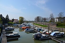
IJsselharbour of Zutphen
-
Zutphen


.jpg)
See also
 In Spanish: Zutphen para niños
