
Central Naugatuck Valley facts for kids
Quick facts for kids
Central Naugatuck Valley
|
|
|---|---|

The Central Naugatuck Valley Region of Connecticut
|
|
| Country | United States |
| State | Connecticut |
| County | New Haven |
| County | Litchfield |
| Area | |
| • Total | 309.0 sq mi (800.3 km2) |
| Highest elevation | 1,133 ft (345 m) |
| Lowest elevation | 20 ft (6 m) |
| Population
(2010)
|
|
| • Total | 287,768 |
| • Density | 931.29/sq mi (359.575/km2) |
| Time zone | UTC-5 (Eastern) |
| • Summer (DST) | UTC-4 (Eastern) |
The Central Naugatuck Valley is a special area in Connecticut. It's located in parts of New Haven and Litchfield counties. This region is about 70 miles (110 km) northeast of New York City. It is also about 110 miles (180 km) southwest of Boston.
The Central Naugatuck Valley includes 13 towns. These towns are Beacon Falls, Bethlehem, Cheshire, Middlebury, Naugatuck, Oxford, Prospect, Southbury, Thomaston, Waterbury, Watertown, Wolcott, and Woodbury.
Contents
Exploring the Central Naugatuck Valley
Rivers and Land in the Valley
The Naugatuck River gives the region its name. This river flows right through the middle of the area. It starts in Torrington and flows for about 40 miles (64 km). Then it joins the Housatonic River in Derby.
The Central Naugatuck Valley is one of three parts of the larger Naugatuck River Valley. The other parts are the Lower Naugatuck Valley and the Upper Naugatuck Valley.
Who Lives Here? Understanding the Population

In 2010, about 287,768 people lived in the Central Naugatuck Valley. This was a 5.6% increase from the year 2000. Some towns grew very fast. Oxford, Middlebury, and Beacon Falls all grew by more than 15%.
Waterbury is the biggest city in the region. It had 110,336 people living there in 2010. This makes it the fifth largest city in Connecticut. Naugatuck and Cheshire are the next largest towns.
The population here is becoming more diverse. This is similar to trends across the state and country. Many different backgrounds and cultures make up the community.
In 2010, there were almost 110,000 households in the region. Many of these were families living together. Some households had single people, and others had single parents.
The average age of people in the region was about 40 years old. About 24% of the population was under 18. About 14.5% were 65 years or older.
The average income per person in the region was $30,779. This was a bit lower than the state average. Incomes can be very different from town to town. For example, Waterbury had a lower average household income. Cheshire had a much higher average household income. About 10.6% of the people lived below the poverty line. This means they earned less money than needed for basic living.
Many people in the region have roots from different countries. The top 10 largest ancestry groups are:
- 23.6% Italian
- 18.0% Irish
- 9.1% German
- 8.9% English
- 7.3% Polish
- 6.5% French
- 2.9% Portuguese
- 2.7% French Canadian
- 2.2% American
- 1.8% Lithuanian
Economy: From Factories to Services
In the past, the Central Naugatuck Valley was known for its many factories. Big companies like Chase Brass and Copper Company and the American Brass Company started here. Timex also has its roots in this area.
However, since the 1960s, many factories moved away. This is called deindustrialization. Companies moved to places where it was cheaper to make things. Now, the region's economy relies more on the service sector. This means more jobs are in areas like healthcare, education, and retail.
Getting Around: Transportation in the Valley
Major Roads and Highways

Interstate 84 and Route 8 are the main highways. Interstate 84 connects the region to Hartford and Boston to the east. It also links to Danbury and New York State to the west.
Route 8 runs north and south. It connects to Torrington and the Litchfield Hills in the north. To the south, it connects to the Lower Naugatuck Valley and Bridgeport. A small part of Interstate 691 is in Cheshire. It links Interstate 84 to other major highways.
Bus Services
Local bus service is provided by CT Transit. Buses mainly serve Waterbury. They also go to nearby towns like Cheshire, Middlebury, Naugatuck, Watertown, and Wolcott. There is also an express bus that runs between Waterbury and Hartford. You can also find intercity buses from Waterbury.
Train Travel
The Waterbury Branch of the Metro-North Railroad has stations in Waterbury, Naugatuck, and Beacon Falls. Most passengers need to change trains in Bridgeport. From Waterbury, it takes about 2 hours and 20 minutes to reach Grand Central Terminal in New York City.
The Railroad Museum of New England offers fun train rides. These seasonal trips run on the Naugatuck Railroad from Thomaston to Waterbury and Torrington.
Air Travel
The Waterbury-Oxford Airport is in Oxford. It's used for corporate, cargo, and fun flights. In 2010, about 137 planes used the airport each day.
How the Region is Governed
Connecticut towns have a strong tradition of "home rule." This means local towns have a lot of power to make their own decisions. Even though Connecticut has counties, they don't have much power over the towns.
Instead, Connecticut is divided into nine planning regions. These regions help with things like transportation and land planning. The Naugatuck Valley Council of Governments (NVCOG) is one of these groups. It helps local leaders work together on common issues and create programs for the whole region.
Places to Visit and See
-
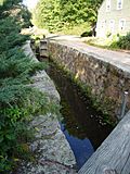
Lock 12 on the Farmington Canal Trail
-
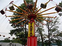
Quassy Park, Middlebury
-
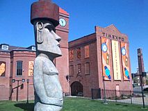
Timexpo Museum, Waterbury
-
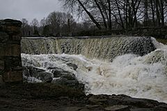
Southford Falls, Southbury
-
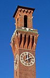
Waterbury Union Station clocktower
-
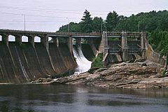
Stevenson Dam, Oxford
-

Brass Mill Center, Waterbury


