
Cupertino, California facts for kids
Quick facts for kids
Cupertino, California
|
|||
|---|---|---|---|
.jpeg)  .jpg) .jpg) .jpg) Clockwise from top: View from the Santa Cruz Mountains; Apple Park (Apple Inc. HQ); Le Petit Trianon; Steve Jobs Theater; Cupertino City Center
|
|||
|
|||

Location of Cupertino in Santa Clara County, California
|
|||

Cupertino, California
Location in the United States
|
|||
| Country | United States | ||
| State | California | ||
| County | Santa Clara | ||
| Region | San Francisco Bay Area | ||
| Incorporated | October 10, 1955 | ||
| Named for | Arroyo San José de Cupertino Saint Joseph of Cupertino | ||
| Government | |||
| • Type | Council–manager | ||
| • Body |
City council
|
||
| Area | |||
| • Total | 11.33 sq mi (29.34 km2) | ||
| • Land | 11.33 sq mi (29.34 km2) | ||
| • Water | 0.00 sq mi (0.00 km2) 0.01% | ||
| Elevation | 236 ft (72 m) | ||
| Population
(2020)
|
|||
| • Total | 60,381 | ||
| • Density | 5,329.3/sq mi (2,058.0/km2) | ||
| Time zone | UTC−8 (Pacific) | ||
| • Summer (DST) | UTC−7 (PDT) | ||
| ZIP Codes |
95014, 95015
|
||
| Area codes | 408/669 | ||
| FIPS code | 06-17610 | ||
| GNIS feature IDs | 277496, 2410278 | ||


Cupertino (/ˌkuːpərˈtiːnoʊ/ KOOP-ər-TEEN-oh) is a city in Santa Clara County, California, United States. It is located west of San Jose, at the edge of the Santa Clara Valley. Some parts of the city reach into the hills of the Santa Cruz Mountains. In 2020, about 60,381 people lived there.
Cupertino is famous for being the home of Apple Inc.. Their main office, Apple Park, is located in the city. The city is named after a local creek, which was named by a Spanish explorer's mapmaker. He named it after Saint Joseph of Cupertino.
Cupertino officially became a city in 1955. However, people were already living and working there in the early 1800s. At first, it was a farming area. Farmers grew prunes, apricots, and cherries. There was also a winery by the late 1800s.
Cupertino grew a lot in the 1950s. This was because many new homes were built after World War II. This growth happened as Silicon Valley began to form nearby. By the 1960s, technology companies like Apple and Hewlett-Packard started to move into the city.
Today, Cupertino is still a very important part of Silicon Valley. Many people who live there have high incomes. The city's economy is mostly based on technology companies. This includes big companies like Apple and many smaller tech startups.
Contents
What's in a Name?
Cupertino got its name from a creek called Arroyo San José de Cupertino. This creek is now known as Stevens Creek. A mapmaker for Spanish explorer Juan Bautista de Anza named the creek after Saint Joseph of Cupertino.
The name Cupertino became popular because of John T. Doyle. He was a lawyer from San Francisco. He named his winery on McClellan Road Cupertino. After the year 1900, people started calling the whole area Cupertino. Before that, it was known as West Side.
A Brief History of Cupertino

In the 1800s, Cupertino was a small farming village. It was located where Stevens Creek Road and Saratoga-Mountain View Road met. This spot is now where the City Hall stands. Back then, the area was called the West Side. It was mostly covered with orchards growing prunes, plums, apricots, and cherry trees. A winery also started operating on Montebello Ridge in the late 1800s.
Over time, railroads, electric railways, and dirt roads were built through the farmlands. Monta Vista, one of Cupertino's first housing areas, was built because of the electric railway.
After World War II, many people moved to the Santa Clara Valley. This caused a big change in the area. The "Valley of Heart's Delight" became "Silicon Valley". In 1954, people started working to make Cupertino an official city. On September 27, 1955, voters said "yes" to the idea. Cupertino officially became the 13th city in Santa Clara County on October 10, 1955.
A big step for Cupertino was the creation of VALLCO Business and Industrial Park. This happened in the early 1960s. Many landowners joined their properties to form this park. The name VALLCO came from the names of the main developers. A shopping center, and later the Vallco Fashion Park, were also built.
De Anza College opened in 1967. The college is named after Juan Bautista De Anza. It is built on land that used to be a winery. The old mansion from the winery is now the California History Center. In 2022, De Anza College had over 16,000 students.
By the 1980s, Apple Inc. and Hewlett-Packard were the main technology companies in Cupertino. Many new homes were built quickly in the following years. Neighborhoods like Fairgrove, Garden Gate, Monta Vista, and Seven Springs were created. Cupertino is known for its very high home prices.
In 2010, HP moved its workers to Palo Alto. They closed their campus in Cupertino. Apple then bought this land from HP. Apple used the land to build its new main office, Apple Park.
Cupertino's Location and Weather

Cupertino is located at the southern end of the San Francisco Bay. The eastern part of the city is flat. The western part of the city goes up into the Santa Cruz Mountains. Cupertino is next to San Jose and Santa Clara to the east. It borders Saratoga to the south and Sunnyvale and Los Altos to the north.
Several creeks flow through Cupertino. These include Permanente Creek, Stevens Creek, and San Tomas Aquino Creek.
The city covers about 11.3 square miles (29.3 square kilometers). Almost all of this area is land.
Cupertino's Climate
Cupertino has a warm-summer Mediterranean climate. This means it has warm to hot, dry summers. Its winters are cool and wet.
| Climate data for Cupertino, California | |||||||||||||
|---|---|---|---|---|---|---|---|---|---|---|---|---|---|
| Month | Jan | Feb | Mar | Apr | May | Jun | Jul | Aug | Sep | Oct | Nov | Dec | Year |
| Record high °F (°C) | 79 (26) |
89 (32) |
89 (32) |
94 (34) |
104 (40) |
108 (42) |
111 (44) |
103 (39) |
109 (43) |
100 (38) |
96 (36) |
87 (31) |
111 (44) |
| Mean daily maximum °F (°C) | 58.4 (14.7) |
62.2 (16.8) |
65.7 (18.7) |
70 (21) |
74.3 (23.5) |
79.1 (26.2) |
82 (28) |
81.7 (27.6) |
81.2 (27.3) |
75.5 (24.2) |
66.8 (19.3) |
59 (15) |
71.3 (21.9) |
| Daily mean °F (°C) | 48.3 (9.1) |
51.6 (10.9) |
54 (12) |
57 (14) |
60.7 (15.9) |
64.7 (18.2) |
67.3 (19.6) |
67 (19) |
65.9 (18.8) |
61.2 (16.2) |
54.3 (12.4) |
48.9 (9.4) |
58.4 (14.6) |
| Mean daily minimum °F (°C) | 38.2 (3.4) |
41.1 (5.1) |
42.4 (5.8) |
43.9 (6.6) |
47.1 (8.4) |
50.2 (10.1) |
52.6 (11.4) |
52.4 (11.3) |
50.6 (10.3) |
47 (8) |
41.8 (5.4) |
38.8 (3.8) |
45.5 (7.5) |
| Record low °F (°C) | 19 (−7) |
23 (−5) |
28 (−2) |
29 (−2) |
32 (0) |
31 (−1) |
38 (3) |
39 (4) |
36 (2) |
30 (−1) |
24 (−4) |
20 (−7) |
19 (−7) |
| Average rainfall inches (cm) | 3 (7.6) |
2.6 (6.6) |
2.3 (5.8) |
1 (2.5) |
0.4 (1.0) |
0.1 (0.25) |
0 (0) |
0 (0) |
0.3 (0.76) |
0.6 (1.5) |
1.5 (3.8) |
2.7 (6.9) |
14.5 (36.71) |
| Average rainy days | 10 | 9 | 9 | 5 | 3 | 1 | 0 | 0 | 1 | 3 | 6 | 9 | 56 |
| Source: Monthly- All Data for Cupertino- Santa Clara University, California | |||||||||||||
Cupertino's Neighborhoods
Cupertino has many different neighborhoods. Most of them were built after the 1960s. For example, the area between Stevens Creek Boulevard and Lawrence Expressway has many homes built in the 1950s.
Some of Cupertino's newest areas were actually its oldest housing tracts. Monta Vista and Rancho Rinconada were built outside the city limits in the 1950s. Rancho Rinconada became part of the city in 1999. The last part of Monta Vista joined in 2004. The Seven Springs neighborhood was built in the late 1980s. Oak Valley is the newest neighborhood, built around the year 2000. It is next to Rancho San Antonio Park.
Cupertino is known for its very expensive homes. In 2022, most homes cost millions of dollars. Even smaller homes started around $2 million.
Who Lives in Cupertino?
| Historical population | |||
|---|---|---|---|
| Census | Pop. | %± | |
| 1960 | 3,664 | — | |
| 1970 | 17,895 | 388.4% | |
| 1980 | 34,297 | 91.7% | |
| 1990 | 40,263 | 17.4% | |
| 2000 | 50,546 | 25.5% | |
| 2010 | 58,302 | 15.3% | |
| 2020 | 60,381 | 3.6% | |
| U.S. Decennial Census | |||

In 2010, about 63% of Cupertino's population was of Asian background. This is much higher than the average for Santa Clara County.
Money magazine ranked Cupertino as the 27th best place to live in 2012. It was the second-highest ranked city in California. In 2014, Movoto Real Estate said Cupertino was the seventh "happiest" suburb in the United States. It scored high in income, safety, marriage, and education.
In 2015, Forbes magazine said Cupertino was one of the most educated places in the U.S. This was based on how many people had high school and college degrees.
Population Details (2010)

The 2010 United States Census showed that Cupertino had 58,302 people. Most people lived in homes.
The racial makeup was:
- 31.3% White
- 0.6% Black American
- 0.2% Native American
- 63.3% Asian (including Chinese, Indian, Korean, Japanese, Vietnamese)
- 1.1% from other races
- 3.3% from two or more races
- 3.6% of people were Hispanic.
About 27.6% of the population was under 18 years old. The average age was 39.9 years. For every 100 females, there were about 97 males.
There were 20,181 households. About 47.3% of these had children under 18. Most households (68.4%) were married couples. About 62.6% of homes were owned by the people living in them. The rest were rented.
Cupertino's Economy

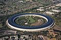
Cupertino is often called the "heart" of Silicon Valley. Many computer and technology companies started here. The new main office for Apple Inc. is in Cupertino. It is a large, round building called Apple Park. This campus covers 150 acres (60 hectares). It is located near Interstate 280. Apple bought this land in parts, starting in 2006.
On June 7, 2011, Steve Jobs showed the plans for the new Apple Park campus. The campus can hold 13,000 employees. They work in one main four-story circular building. The building is surrounded by lots of green space. Most parking is underground.

In 2002, Cupertino had about 25,780 workers. The unemployment rate was 4.5%. This was lower than the average for Santa Clara County.
One important employer in the area is the Permanente Quarry. This is a rock quarry and cement plant. It is located in the hills west of Cupertino. Henry J. Kaiser started it in 1939. It provided most of the cement for building the Shasta Dam. A railroad line runs through the city only for this cement plant.
Top Employers in Cupertino
Here are the top employers in Cupertino, based on a 2020–21 report:
| # | Employer |
|---|---|
| 1 | Apple |
| 2 | Cupertino Union School District |
| 3 | Corinthian International Parking Services |
| 4 | Synoptic Systems Inc. |
| 5 | De Anza Community College District |
| 6 | Target Stores, Inc. |
| 7 | Fremont Union High School District |
| 8 | Forum Healthcare Center |
| 9 | Whole Foods Market |
| 10 | Mobileum, Inc. |
Learning in Cupertino

The Santa Clara County Library runs the Cupertino Library. It is next to the city hall. The library was rebuilt in 2004. It is the busiest library branch in the county. About 3 million items are checked out each year.
The San Francisco Japanese School holds classes in Cupertino. It is a weekend program for Japanese children living abroad. They use J.F. Kennedy Middle School and Harker, a private school.
Schools for Kids and Teens

Cupertino is known for its excellent schools. Students often achieve high scores. For example, Murdock-Portal Elementary and Faria Elementary School had some of the highest scores in California in 2013. John F. Kennedy Middle School was the best public middle school in the state. Lawson Middle School was the third best. Also, Monta Vista High School is ranked among the top public high schools in the country.
Younger students (Kindergarten to 8th grade) go to schools in the Cupertino Union School District. High school students attend schools in the Fremont Union High School District. There is a small part of the city that belongs to the Santa Clara Unified School District.
Cupertino High School and its feeder school, Hyde Middle School, are in the Rancho Rinconada area. Monta Vista High School and its feeder, Kennedy Middle School, are in the Monta Vista neighborhood. Lawson Middle School sends most of its students to Cupertino and Monta Vista High. Homestead High School is also in Cupertino, near the border with Sunnyvale.
Colleges and Universities
Cupertino is home to De Anza College. This is one of two community colleges in the Foothill–De Anza Community College District. The University of San Francisco also has smaller campuses in Cupertino.
Getting Around Cupertino

Cupertino has a good road system. Two freeways, State Route 85 and Interstate 280, cross each other in Cupertino. The city has wide roads with traffic lights at all major crossings. Most streets have sidewalks.
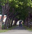
Many boulevards in Cupertino have bike lanes. There is also an extension of the Stevens Creek Trail. This trail goes through McClellan Ranch Park and Blackberry Farm. Many bikes are seen around De Anza College in the mornings and at noon.
On April 30, 2009, Cupertino opened the Mary Avenue Bicycle Footbridge. This was the first cable-stayed bridge for bikes and walkers over a California freeway. It connects the north and south parts of the Stevens Creek Trail. The bridge cost $14.8 million to build.
The Union Pacific Railroad has a train track that goes to the Lehigh Permanente Cement Plant. This track is only for the quarry. Very few other trains use it.

Cupertino does not have commuter trains or light rail service. Caltrain runs through nearby cities. The Santa Clara Valley Transportation Authority (VTA) light rail goes to Campbell. VTA also provides bus service in Cupertino.
Cupertino is not on the coast. It uses the Port of Oakland for most of its shipping by sea. For air travel, people use San Jose International Airport in San Jose. The closest small airport is Palo Alto Airport of Santa Clara County in Palo Alto.
In 2019, Cupertino started a new public transportation service with Via Transportation. It's called Via. Riders can use a smartphone app to call a shared ride. This service covers all of Cupertino. It also has a special zone around the Sunnyvale Caltrain station for people who commute.
Famous People from Cupertino
- Matt Arya – soccer player
- Matthew Axelson – Navy SEAL
- Kris Bubic – baseball player
- Redmond Burke – pediatric heart surgeon
- Raymond Carver – writer and poet
- Aaron Eckhart – actor
- Scott Erickson – baseball player
- Paul Fong – California politician
- Clark Glasson – golf course architect
- Adyashanti – spiritual teacher
- Mark Tapio Kines – film director, writer, producer
- Steve Jobs – co-founder of Apple Inc.
- David Kramer – soccer player
- Ronnie Lott – football player
- Bryan Mantia – drummer
- Kurt Rambis – basketball player and coach
- Josiah Little Pickard – school administrator
- Adam Peters – NFL executive
- Daniel Puder – mixed martial arts fighter
- Fred Sablan – musician
- Charlie Tagawa – Japanese-American musician
- Khyri Thomas – basketball player
- Savita Vaidhyanathan – politician
- Elizabeth Lowe Watson – leader in the California Equal Suffrage Association
- Sandy Wihtol – baseball player
- Steve Wozniak – co-founder of Apple Inc.
- Cliff Yiskis – NASCAR driver
Sister Cities
Cupertino has "sister city" relationships with these cities:
 Copertino, Italy
 Bhubaneswar, India
 Hsinchu, Taiwan
 Toyokawa, Japan
Friendship Cities
Cupertino also has friendly relations with these cities:
 Jiangmen, China
- Jilin City, China
- Luoyang, China
- Shenzhen, China
- Taichung, Taiwan
- Taipei, Taiwan
- Tongxiang, China
- Xianning, China
- Yilan City, Taiwan
- Zhaoqing, China
- New Taipei, Taiwan
Images for kids
-
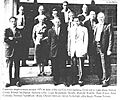
Cupertino Improvement Assn., 1954
-
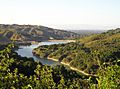
Stevens Creek Reservoir
-
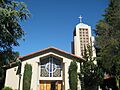
Saint Joseph of Cupertino Church
-
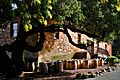
Picchetti Brothers Winery
-
The headquarters of Apple Inc. on Apple Park Way in Cupertino
-
Cali Mill Plaza, containing the Cypress Hotel and various restaurants
-
McClellan Ranch Preserve
-
Homestead High School
-
Cupertino Memorial Park
-
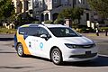
Public transit in Cupertino, California is powered by Via Transportation and utilizes on-demand shuttles.
See also
 In Spanish: Cupertino (California) para niños
