
Geography of Denver facts for kids
Denver is a big city in Colorado, USA. It's located right where the Rocky Mountains meet the flat High Plains. This gives Denver amazing mountain views to the west and wide-open spaces to the east.
The city covers about 401 square kilometers (155 square miles). Most of this area is land, with a small part being water. Denver is a lively place, known for its sunny weather and outdoor activities.
Contents
Denver's Neighbors
Denver shares its borders with several other counties and cities. Knowing its neighbors helps us understand where Denver fits in the larger area.
Nearby Counties
- Adams County, Colorado - to the north and east
- Arapahoe County, Colorado - to the south and east
- Jefferson County, Colorado - to the west
Neighboring Cities
Denver is surrounded by many towns and cities. Here are some of them:
- Commerce City and Brighton to the north.
- Aurora and Glendale to the east.
- Greenwood Village, Cherry Hills Village, Englewood, Sheridan, Bow Mar, and Littleton to the south.
- Lakewood, Edgewater, Wheat Ridge, Mountain View, and Lakeside to the west.
- Arvada to the northwest.
Denver's Climate and Weather
Denver has a special climate that gets lots of sunshine! It's called a semi-arid climate, which means it's usually dry. The nearby Rocky Mountains play a big role in Denver's weather.
| Weather chart for Denver | |||||||||||||||||||||||||||||||||||||||||||||||
|---|---|---|---|---|---|---|---|---|---|---|---|---|---|---|---|---|---|---|---|---|---|---|---|---|---|---|---|---|---|---|---|---|---|---|---|---|---|---|---|---|---|---|---|---|---|---|---|
| J | F | M | A | M | J | J | A | S | O | N | D | ||||||||||||||||||||||||||||||||||||
|
0.4
44
17
|
0.4
46
19
|
0.9
54
26
|
1.7
62
33
|
2.1
72
43
|
2
82
52
|
2.2
89
59
|
1.7
87
58
|
1
79
48
|
1
65
37
|
0.6
52
24
|
0.4
44
17
|
||||||||||||||||||||||||||||||||||||
| temperatures in °F precipitation totals in inches source: NOAA |
|||||||||||||||||||||||||||||||||||||||||||||||
|
Metric conversion
|
|||||||||||||||||||||||||||||||||||||||||||||||
Sunshine and Precipitation
Denver gets about 3,100 hours of sunshine each year. This makes it one of the sunniest big cities! The average temperature is about 10 degrees Celsius (50 degrees Fahrenheit). Denver gets around 36 centimeters (14 inches) of rain and snow each year.
Winter Weather in Denver
Winters in Denver are usually dry and can be mild or moderately cold. Even if a lot of snow falls in the mountains, Denver often stays drier. This is because of something called orographic lift. It dries out the air as it passes over the Front Range mountains. Sometimes, warm chinook winds blow down from the mountains. These winds can melt snow and make temperatures rise quickly.
Spring and Summer Weather
Spring brings many changes to Denver. Arctic air from the north can bring snowstorms. March is often the second snowiest month. Warm air from the Gulf of Mexico can also bring the first thunderstorms of the year.
In mid-July, the monsoon season starts. This brings tropical moisture and short afternoon thunderstorms. Even with this moisture, the air usually stays dry. Hot days above 32 degrees Celsius (90 degrees Fahrenheit) happen about 38 days a year.
Autumn Weather
In autumn, the monsoon season ends. As colder air arrives, it can mix with moisture from the Pacific Northwest. This often brings snow to the city. November is Denver's third snowiest month.
| Climate data for Denver (DIA), 1981−2010 normals, extremes 1872−present | |||||||||||||
|---|---|---|---|---|---|---|---|---|---|---|---|---|---|
| Month | Jan | Feb | Mar | Apr | May | Jun | Jul | Aug | Sep | Oct | Nov | Dec | Year |
| Record high °F (°C) | 76 (24) |
80 (27) |
84 (29) |
90 (32) |
95 (35) |
105 (41) |
105 (41) |
105 (41) |
97 (36) |
90 (32) |
80 (27) |
79 (26) |
105 (41) |
| Mean maximum °F (°C) | 64.7 (18.2) |
66.5 (19.2) |
73.9 (23.3) |
80.8 (27.1) |
87.8 (31.0) |
95.9 (35.5) |
99.2 (37.3) |
96.4 (35.8) |
91.5 (33.1) |
82.7 (28.2) |
73.6 (23.1) |
64.9 (18.3) |
99.9 (37.7) |
| Mean daily maximum °F (°C) | 44.0 (6.7) |
46.2 (7.9) |
54.4 (12.4) |
61.5 (16.4) |
71.5 (21.9) |
82.4 (28.0) |
89.4 (31.9) |
87.2 (30.7) |
78.5 (25.8) |
65.3 (18.5) |
52.1 (11.2) |
42.8 (6.0) |
64.6 (18.1) |
| Daily mean °F (°C) | 30.7 (−0.7) |
32.5 (0.3) |
40.4 (4.7) |
47.4 (8.6) |
57.1 (13.9) |
64.7 (18.2) |
74.2 (23.4) |
72.5 (22.5) |
63.4 (17.4) |
50.9 (10.5) |
38.3 (3.5) |
30.0 (−1.1) |
50.5 (10.3) |
| Mean daily minimum °F (°C) | 17.4 (−8.1) |
18.9 (−7.3) |
26.4 (−3.1) |
33.3 (0.7) |
42.7 (5.9) |
52.3 (11.3) |
58.9 (14.9) |
57.9 (14.4) |
48.3 (9.1) |
36.6 (2.6) |
24.5 (−4.2) |
17.1 (−8.3) |
36.2 (2.3) |
| Mean minimum °F (°C) | −3 (−19) |
−1.3 (−18.5) |
10.4 (−12.0) |
19.7 (−6.8) |
31.0 (−0.6) |
41.6 (5.3) |
50.9 (10.5) |
49.9 (9.9) |
34.4 (1.3) |
21.5 (−5.8) |
5.5 (−14.7) |
−4.5 (−20.3) |
−12.7 (−24.8) |
| Record low °F (°C) | −29 (−34) |
−25 (−32) |
−11 (−24) |
−2 (−19) |
19 (−7) |
30 (−1) |
42 (6) |
40 (4) |
17 (−8) |
−2 (−19) |
−18 (−28) |
−25 (−32) |
−29 (−34) |
| Average precipitation inches (mm) | 0.41 (10) |
0.37 (9.4) |
0.92 (23) |
1.71 (43) |
2.12 (54) |
1.98 (50) |
2.16 (55) |
1.69 (43) |
0.96 (24) |
1.02 (26) |
0.61 (15) |
0.35 (8.9) |
14.30 (363) |
| Average snowfall inches (cm) | 7.0 (18) |
5.7 (14) |
10.7 (27) |
6.8 (17) |
1.1 (2.8) |
0 (0) |
0 (0) |
0 (0) |
1.3 (3.3) |
4.0 (10) |
8.7 (22) |
8.5 (22) |
53.8 (137) |
| Average precipitation days (≥ 0.01 in) | 4.1 | 5.3 | 5.9 | 9.1 | 9.4 | 8.4 | 8.3 | 8.6 | 6.5 | 5.3 | 4.7 | 4.1 | 79.7 |
| Average snowy days (≥ 0.1 in) | 5.0 | 5.3 | 5.8 | 4.1 | 0.6 | 0 | 0 | 0 | 0.5 | 1.8 | 4.9 | 5.3 | 33.3 |
| Average relative humidity (%) | 55.2 | 55.8 | 53.7 | 49.6 | 51.7 | 49.3 | 47.8 | 49.3 | 50.1 | 49.2 | 56.3 | 56.6 | 52.0 |
| Mean monthly sunshine hours | 215.3 | 211.1 | 255.6 | 276.2 | 290.0 | 315.3 | 325.0 | 306.4 | 272.3 | 249.2 | 194.3 | 195.9 | 3,106.6 |
| Percent possible sunshine | 72 | 70 | 69 | 69 | 65 | 70 | 71 | 72 | 73 | 72 | 65 | 67 | 70 |
| Source: NOAA (sun 1961−1990) | |||||||||||||
Denver's Neighborhoods

Denver is divided into 79 different neighborhoods. These areas help the city plan and manage services. Each neighborhood has its own unique feel and community.
Some neighborhoods are very well-known. For example, LoDo (short for "Lower Downtown") is a historic and trendy area. Other popular neighborhoods include Capitol Hill, Washington Park, and Five Points. These areas are often where people live, work, and enjoy the city.
Getting Around Denver
Street System

Most of Denver has a simple street grid. Streets run either north-south or east-west. This makes it easy to find your way around. Major streets like Broadway and Ellsworth Avenue act as "0" lines for numbering blocks.
Downtown Denver has an older, different street system. Its streets run diagonally, northeast-southwest and northwest-southeast. This unique layout helps melt snow! The diagonal streets get sun in both the morning and afternoon, which helps clear the snow faster.
Major Highways
Denver is served by two main interstate highways: I-25 and I-70. These highways cross paths in an area locally called "the mousetrap."
- I-70 runs east-west, connecting Denver to places like Utah and Baltimore, Maryland.
- I-25 runs north-south, going from New Mexico through Denver to Wyoming.
Other highways like I-225 and I-76 also help people travel around Denver and to nearby states. A big project called "T-REX" recently added more highway lanes and a light rail line along I-25. This made travel much easier.
Public Transportation

The Regional Transportation District (RTD) manages public transportation in the Denver area. RTD operates many buses and several light rail lines. These lines connect downtown Denver to many suburbs.
There are also two commuter rail lines. These lines will eventually connect to places like Boulder, Longmont, and the Denver International Airport. This makes it easy to get around without a car.
Train Service
If you want to travel by train to or from Denver, Amtrak offers service. The California Zephyr train runs from Chicago to the San Francisco Bay Area, stopping in Denver. During winter, the Winter Park Express takes people from Denver to Winter Park Resort for skiing. Both trains stop at Denver's historic Union Station.
Airports

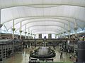
- Denver International Airport (DIA) is a very busy airport. It's one of the largest airports in the United States by land area. Many people travel through DIA every year.
- Before DIA, Denver had Stapleton International Airport, which closed in 1995.
Images for kids
-
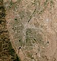
Satellite image of the Denver Metropolitan area
-

The Front Range as seen from Westlands Park in Greenwood Village.
-
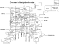
Denver's 79 neighborhoods offer a variety of living experiences.
-
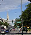
Colfax Ave at Broadway, where the downtown and the normal city grid meet
-
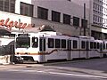
Denver RTD Light Rail car at 16th & Stout
-
Denver International Airport

